world.wikisort.org - Netherlands
's Gravenmoer is a village in the Dutch province of North Brabant. It is located in the municipality of Dongen, about 3 km north of the town of Dongen. The village has a population of about 2190 inhabitants, including the farmlands to the north of the village.[3]
's Gravenmoer | |
|---|---|
Village | |
 Shop is 's-Gravenmoer | |
 's Gravenmoer Location in the province of North Brabant in the Netherlands  's Gravenmoer 's Gravenmoer (Netherlands) | |
| Coordinates: 51°39′31″N 4°56′28″E | |
| Country | Netherlands |
| Province | North Brabant |
| Municipality | Dongen |
| Area | |
| • Total | 5.23 km2 (2.02 sq mi) |
| Elevation | 1.6 m (5.2 ft) |
| Population (2021)[1] | |
| • Total | 2,260 |
| • Density | 430/km2 (1,100/sq mi) |
| Time zone | UTC+1 (CET) |
| • Summer (DST) | UTC+2 (CEST) |
| Postal code | 5109[1] |
| Dialing code | 0462 |
History
The village was first mentioned in 1326 as Sgraven moer, and means "moorland of the count". In 1293, Floris V, Count of Holland donated the land to Steven van Waalwijk for the excavation of peat.[4] The economy used to be dominated by peat. In the 16th century, the 's-Gravenmoersche Vaart was dug after an earlier canal had silted.[5]
The tower of the Dutch Reformed church was built in the 14th century. The nave dates from the 15th century. In 1672, it was damaged by fire and rebuilt in 1680.[5]
's-Gravenmoer was home to 420 people in 1840.[6] Entrop used to manufactor bikes, four cars, and one double-decker bus in factory in 's-Gravenmoer. In 1909, he constructed the first car of the Netherlands.[6] 's Gravenmoer was a separate municipality until 1997, when it became a part of Dongen.[7] In the 19th century, the municipality consisted of two neighbourhoods, called Dorp or Straat ("Village", or "Street") and ('s-Gravenmoersche) Vaart ("Canal"). The former part is now the village of 's Gravenmoer, formerly also called 's-Moer.[8]
's-Gravenmoersche Vaart should not be confused with the contemporary village Vaart, which lies along the same canal a short distance to the south. 's-Gravenmoersche Vaart is now seen as part of the village of 's-Gravenmoer, although it is situated 1 km to the east of the village center.
Gallery
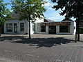 Bakery
 House in 's-Gravenmoer
 House in 's-Gravenmoer
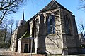 St Martinus Church


References
- "Kerncijfers wijken en buurten 2021". Central Bureau of Statistics. Retrieved 15 April 2022.
- "Postcodetool for 5109AA". Actueel Hoogtebestand Nederland (in Dutch). Het Waterschapshuis. Retrieved 15 April 2022.
- Statistics Netherlands, 2007. Figures are for the year 2006. Statistics are available in Google Earth format.
- "Gravenmoer - (geografische naam)". Etymologiebank (in Dutch). Retrieved 15 April 2022.
- Chris Kolman & Ronald Stenvert (1997). 's-Gravenmoer (in Dutch). Zwolle: Waanders. ISBN 90 400 9945 6. Retrieved 15 April 2022.
- "'s-Gravenmoer". Plaatsengids (in Dutch). Retrieved 15 April 2022.
- Ad van der Meer and Onno Boonstra, Repertorium van Nederlandse gemeenten, KNAW, 2011.
- Abraham Jacob van der Aa, "Aardrijkskundig woordenboek der Nederlanden", vol. 4 (E-G), 1843, p. 830-835.
External links
 Media related to 's-Gravenmoer at Wikimedia Commons
На других языках
[de] ’s Gravenmoer
’s Gravenmoer ist ein Dorf im Norden der niederländischen Provinz Noord-Brabant. In ihm leben 2280 Einwohner (Stand: 1. Januar 2020).[1] Seit 1997 ist die ehemals selbständige Gemeinde Ortsteil der Gemeinde Dongen.- [en] 's Gravenmoer
Другой контент может иметь иную лицензию. Перед использованием материалов сайта WikiSort.org внимательно изучите правила лицензирования конкретных элементов наполнения сайта.
WikiSort.org - проект по пересортировке и дополнению контента Википедии