world.wikisort.org - Netherlands
't Zandt (Dutch pronunciation: [ət ˈsɑnt])[3] is a village in the Dutch province of Groningen. It is located in the municipality of Eemsdelta.
't Zandt | |
|---|---|
Village | |
 't Zandt in 2011 | |
 't Zandt Location of 't Zandt in the province of Groningen  't Zandt 't Zandt (Netherlands) | |
| Coordinates: 53°21′57″N 6°46′28″E | |
| Country | Netherlands |
| Province | Groningen |
| Municipality | Eemsdelta |
| Area | |
| • Total | 33.74 km2 (13.03 sq mi) |
| Elevation | 1.1 m (3.6 ft) |
| Population (2021)[1] | |
| • Total | 970 |
| • Density | 29/km2 (74/sq mi) |
| Postal code | 9915[1] |
| Dialing code | 0596 |
't Zandt was a separate municipality until 1990, when it was merged with Loppersum.[4] The municipality covered the villages 't Zandt, Zeerijp, Leermens, Eenum and Oosterwijwerd, and the hamlets Zijldijk, Kolhol, Korendijk and 't Zandstervoorwerk.[5]
History
The village was first mentioned in 1257 as "in Sonde", and means sand. That year, the monks of Wittewierum started to a dike in order to polder the former Fivel estuary. The polder was completed in 1266, and a sluice was constructed in 1272.[6] At the intersection of the new dike and the perpendicular older dike, a settlement appeared.[7]
The Dutch Reformed church dates from the late-13th century, and was enlarged in the 15th century. The tower is detached from the church, and dates from the early 13th century.[7]
't Zandt was home to 779 people in 1840.[8] In 1990, it ceased to be an independent municipality and was merged into Loppersum.[8]
Gallery
 Former town hall
 Fire department
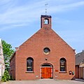 Reformed church
 Zandstermaar


References
- "Kerncijfers wijken en buurten 2021". Central Bureau of Statistics. Retrieved 8 April 2022.
two entries
- "Postcodetool for 9915PA". Actueel Hoogtebestand Nederland (in Dutch). Het Waterschapshuis. Retrieved 8 April 2022.
- In isolation, Zandt is pronounced [ˈzɑnt].
- Ad van der Meer and Onno Boonstra, Repertorium van Nederlandse gemeenten, KNAW, 2011.
- Abraham Jacob van der Aa, "Aardrijkskundig woordenboek der Nederlanden", vol. 1 (A), 1839.
- "Zandt - (geografische naam)". Etymologiebank (in Dutch). Retrieved 8 April 2022.
- Ronald Stenvert & Redmer Alma (1998). "'t Zandt" (in Dutch). Zwolle: Waanders. ISBN 90 400 9258 3. Retrieved 8 April 2022.
- "'t Zandt". Plaatsengids (in Dutch). Retrieved 8 April 2022.
External links
 Media related to 't Zandt at Wikimedia Commons
This Groningen location article is a stub. You can help Wikipedia by expanding it. |
Другой контент может иметь иную лицензию. Перед использованием материалов сайта WikiSort.org внимательно изучите правила лицензирования конкретных элементов наполнения сайта.
WikiSort.org - проект по пересортировке и дополнению контента Википедии