world.wikisort.org - Nepal
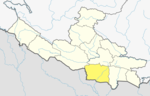
Bangai is a village development committee in Kapilvastu District in the Lumbini Zone of southern Nepal. Locally, there are two places known by the name of Bangai, Gherawa Bangain in the east and Koili Bangain in the west, separated by the distance of 1 km. Mahendra Highway (Mahendra Rajmarg in Nepali) or east–west highway passes through it. The Banganga river marks the south boundary of Bangain. Manoharipur is the first adjacent village in the south of it which lies in the Kopawa V.D.C. Locally, Bangain is famous for its funeral site on the bank of Banganga known as Laxmanghat. It is also a major shopping hub within 5 km of its radius due to its proximity with the highway. At the time of the 1991 Nepal census it had a population of 2983 people living in 528 individual households.[1]
Bangai
बंगाई | |
|---|---|
Village development committee | |
| Country | |
| Zone | Lumbini Zone |
| District | Kapilvastu District |
| Population (1991) | |
| • Total | 2,983 |
| Time zone | UTC+5:45 (Nepal Time) |
References
- "Nepal Census 2001". Nepal's Village Development Committees. Digital Himalaya. Archived from the original on 12 October 2008. Retrieved 14 December 2008.
Kapilvastu District | ||
|---|---|---|
Headquarters: Kapilvastu Municipality | ||
| Municipalities |
|  |
| Rural municipalities |
| |
| Former VDCs |
| |
List of municipalities and rural municipalities of Nepal | ||
This article about a location in Kapilvastu District, Nepal is a stub. You can help Wikipedia by expanding it. |
Другой контент может иметь иную лицензию. Перед использованием материалов сайта WikiSort.org внимательно изучите правила лицензирования конкретных элементов наполнения сайта.
WikiSort.org - проект по пересортировке и дополнению контента Википедии