world.wikisort.org - Messico
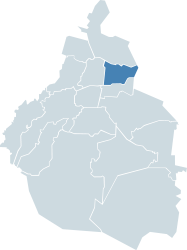
Venustiano Carranza è una delle 16 delegazioni del Distretto Federale Messicano. È situata nella zona centro orientale di Città del Messico. Confina a nord con la Delegazione Gustavo A. Madero, ad ovest con la Delegazione Cuauhtémoc, a sud con la delegazione Iztacalco e ad est con lo Stato del Messico. Il suo nome è in onore di Venustiano Carranza, capo rivoluzionario che promulgò la Costituzione messicana del 1917 e fu primo presidente costituzionale del Messico.
|
Questa voce o sezione sull'argomento centri abitati del Messico non cita le fonti necessarie o quelle presenti sono insufficienti.
|
| Venustiano Carranza delegazione | ||
|---|---|---|
| ||
 | ||
| Localizzazione | ||
| Stato | ||
| Stato federato | ||
| Amministrazione | ||
| Capoluogo | Colonia Jardin balbuena | |
| Sindaco | Alejandro Piña Medina (2009-2012, PRD) | |
| Territorio | ||
| Coordinate del capoluogo | 19°25′00″N 99°06′50″W | |
| Altitudine | 2 237 m s.l.m. | |
| Superficie | 33,42 km² | |
| Abitanti | 447 459 | |
| Densità | 13 388,96 ab./km² | |
| Altre informazioni | ||
| Fuso orario | UTC-7 | |
| ISO 3166-2 | MX-DF | |
| Cartografia | ||
 Colonia Jardin balbuena | ||
 | ||
| Sito istituzionale | ||

L'Aeroporto Internazionale di Città del Messico si trova in questa delegazione.
Altri progetti
 Wikimedia Commons contiene immagini o altri file su Delegazione Venustiano Carranza
Collegamenti esterni
- Sito ufficiale, su vcarranza.cdmx.gob.mx.
На других языках
[de] Venustiano Carranza (Delegación)
19.419204-99.109898[en] Venustiano Carranza, Mexico City
Venustiano Carranza is a borough (demarcación territorial) in the Mexico City. Venustiano Carranza extends from the far eastern portion of the historic center of Mexico City eastward to the Peñón de los Baños and the border dividing the then Federal District from the State of Mexico. Historically, most of the territory was under Lake Texcoco, but over the colonial period into the 20th century, the lake dried up and today the area is completely urbanized. The borough is home to three of Mexico City's major traditional markets, including La Merced, the National Archives of Mexico, the Palacio Legislativo de San Lázaro, the TAPO intercity bus terminal and the Mexico City Airport.[es] Venustiano Carranza (Ciudad de México)
La demarcación territorial Venustiano Carranza se encuentra en la zona centro oriente de Ciudad de México. Colinda al norte con la alcaldía Gustavo A. Madero, al poniente con la alcaldía Cuauhtémoc, al sur con la alcaldía Iztacalco y al oriente con el municipio de Nezahualcóyotl. Este nombre fue dado en honor a Venustiano Carranza, jefe revolucionario que promulgó la Constitución Mexicana de 1917. Su emblema representa el símbolo del pueblo Xochiacan, cuya imagen aparece en el Códice Mendoza (o también llamado Mendocino) en donde la flor significa: "lugar de flores fragantes".- [it] Delegazione Venustiano Carranza
Текст в блоке "Читать" взят с сайта "Википедия" и доступен по лицензии Creative Commons Attribution-ShareAlike; в отдельных случаях могут действовать дополнительные условия.
Другой контент может иметь иную лицензию. Перед использованием материалов сайта WikiSort.org внимательно изучите правила лицензирования конкретных элементов наполнения сайта.
Другой контент может иметь иную лицензию. Перед использованием материалов сайта WikiSort.org внимательно изучите правила лицензирования конкретных элементов наполнения сайта.
2019-2025
WikiSort.org - проект по пересортировке и дополнению контента Википедии
WikiSort.org - проект по пересортировке и дополнению контента Википедии