world.wikisort.org - Mexico
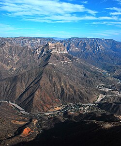
Urique (Tarahumara: Urike) is a town and seat of the municipality of Urique, in the northern Mexican state of Chihuahua. As of 2010, the town of Urique had a population of 1,102,[1] up from 984 as of 2005.[2] Located in the southwest corner of the state in the region of the cliffs, the town is at the bottom of the valley Barranca de Urique, formed by the river of the same name, due to its relatively low elevation above sea level (about 550 meters) the climate of Urique is close to tropical. It's the principal village of the Municipality of Urique.
Urique | |
|---|---|
Town | |
 The town of Urique in the Urique Canyon | |
 Urique Location in Mexico | |
| Coordinates: 27°13′0″N 107°55′0″W | |
| Country | |
| State | Chihuahua |
| Municipality | Urique |
| Elevation | 550 m (1,800 ft) |
| Population (2010) | |
| • Total | 1,102 |
Climate
| Climate data for Urique (1951–2010) | |||||||||||||
|---|---|---|---|---|---|---|---|---|---|---|---|---|---|
| Month | Jan | Feb | Mar | Apr | May | Jun | Jul | Aug | Sep | Oct | Nov | Dec | Year |
| Record high °C (°F) | 38.0 (100.4) |
38.0 (100.4) |
41.0 (105.8) |
43.0 (109.4) |
45.5 (113.9) |
47.0 (116.6) |
46.0 (114.8) |
43.0 (109.4) |
43.5 (110.3) |
43.0 (109.4) |
40.0 (104.0) |
36.0 (96.8) |
47.0 (116.6) |
| Average high °C (°F) | 26.5 (79.7) |
28.6 (83.5) |
31.3 (88.3) |
34.9 (94.8) |
38.2 (100.8) |
39.9 (103.8) |
35.4 (95.7) |
35.1 (95.2) |
35.4 (95.7) |
34.5 (94.1) |
31.2 (88.2) |
27.4 (81.3) |
33.2 (91.8) |
| Daily mean °C (°F) | 18.1 (64.6) |
19.4 (66.9) |
21.7 (71.1) |
25.1 (77.2) |
28.6 (83.5) |
31.2 (88.2) |
28.7 (83.7) |
28.2 (82.8) |
28.0 (82.4) |
25.7 (78.3) |
22.0 (71.6) |
18.8 (65.8) |
24.6 (76.3) |
| Average low °C (°F) | 9.6 (49.3) |
10.1 (50.2) |
12.0 (53.6) |
15.3 (59.5) |
19.1 (66.4) |
22.6 (72.7) |
21.9 (71.4) |
21.4 (70.5) |
20.5 (68.9) |
16.9 (62.4) |
12.8 (55.0) |
10.2 (50.4) |
16.0 (60.8) |
| Record low °C (°F) | 0.0 (32.0) |
1.0 (33.8) |
0.5 (32.9) |
7.0 (44.6) |
11.0 (51.8) |
10.5 (50.9) |
17.0 (62.6) |
17.5 (63.5) |
14.0 (57.2) |
9.5 (49.1) |
5.5 (41.9) |
1.5 (34.7) |
0.0 (32.0) |
| Average precipitation mm (inches) | 41.2 (1.62) |
22.6 (0.89) |
15.1 (0.59) |
5.7 (0.22) |
10.7 (0.42) |
79.6 (3.13) |
187.7 (7.39) |
169.3 (6.67) |
115.1 (4.53) |
52.1 (2.05) |
20.0 (0.79) |
50.2 (1.98) |
769.3 (30.29) |
| Average precipitation days (≥ 0.1 mm) | 3.9 | 2.4 | 1.8 | 0.9 | 1.0 | 7.8 | 19.1 | 16.6 | 10.2 | 4.0 | 2.3 | 3.9 | 73.9 |
| Source: Servicio Meteorologico Nacional[3] | |||||||||||||
References
- "Urique". Catálogo de Localidades. Secretaría de Desarrollo Social (SEDESOL). Retrieved 23 April 2014.
- Instituto Nacional de Estadística y Geografía. Principales resultados por localidad 2005 (ITER). Retrieved on October 25, 2008
- "Estado de Chihuahua-Estacion: Urique (SMN)". Normales Climatologicas 1951–2010 (in Spanish). Servicio Meteorologico Nacional. Archived from the original on 17 March 2019. Retrieved 17 March 2019.
На других языках
- [en] Urique
[es] Urique
Urique (en tarahumara: Urike ‘Lugar de barrancas’) es un pueblo del estado mexicano de Chihuahua, localizado en el extremo suroeste de la entidad, en la región de las barrancas, el pueblo se encuentra en el fondo de la llamada Barranca de Urique, formada por el río del mismo nombre, debido a su baja altitud sobre el nivel del mar, el clima de Urique es cercano al tropical. Es cabecera del municipio de Urique.[ru] Урике
Урике (исп. Urique) — посёлок в Мексике, штат Чиуауа, входит в состав одноимённого муниципалитета и является его административным центром. Численность населения, по данным переписи 2010 года, составила 1102 человека[3].Текст в блоке "Читать" взят с сайта "Википедия" и доступен по лицензии Creative Commons Attribution-ShareAlike; в отдельных случаях могут действовать дополнительные условия.
Другой контент может иметь иную лицензию. Перед использованием материалов сайта WikiSort.org внимательно изучите правила лицензирования конкретных элементов наполнения сайта.
Другой контент может иметь иную лицензию. Перед использованием материалов сайта WikiSort.org внимательно изучите правила лицензирования конкретных элементов наполнения сайта.
2019-2025
WikiSort.org - проект по пересортировке и дополнению контента Википедии
WikiSort.org - проект по пересортировке и дополнению контента Википедии
