world.wikisort.org - Japón
Uruma (うるま市 Uruma-shi?) es una ciudad en la prefectura de Okinawa, Japón.
| Uruma | ||
|---|---|---|
| Ciudad | ||
 | ||
 Bandera | ||
 Uruma Localización de Uruma en Japón | ||
 Ubicación de Uruma | ||
| Coordenadas | 26°22′45″N 127°51′27″E | |
| Entidad | Ciudad | |
| • País |
| |
| • Región | Kyūshū | |
| • Prefectura | Okinawa | |
| Alcalde | Toshio Shimabukuro (desde mayo de 2009) | |
| Superficie | ||
| • Total | 86.00 km² | |
| Altitud | ||
| • Media | 204 m s. n. m. | |
| Población (2013) | ||
| • Total | 118,330 hab. | |
| • Densidad | 1406,24 hab/km² | |
| Huso horario | UTC+9 | |
| Código postal | 904-2292 | |
| Código dantai | 472131[1][2] | |
| Huso horario | Huso horario estándar de Japón (UTC+9) | |
| Número telefónico | 098-974-3111 | |
| Dirección | 1-1-1 Midori-machi, Uruma-shi, Okinawa-ken 904-2292 | |
| Sitio web oficial | ||
Fue formada el 1 de abril de 2005, de la fusión de las antiguas ciudades de Gushikawa y Ishikawa, y las ciudades de Katsuren y Yonashiro, ambos del distrito de Nakagami.[3]
El nombre de la ciudad proviene de un nombre arcaico alternativo para Okinawa en okinawense, lo que significa coral (uru) + isla (ma).
Geografía
Se encuentra cerca del centro de la isla de Okinawa, mirando hacia el este. Consiste en la Península de Yokatsu y las ocho islas de las Islas Yokatsu.
Bases militares de Estados Unidos
- Camp Courtney
- Camp McTureous
- White Beach
Residentes famosos de Uruma
- Finger 5, grupo musical
- HY, banda
- Manami Higa, actriz
- Seijin Noborikawa, cantante
- Takashi Chinen, gimnasta
- Takato Toguchi, boxeador
Referencias
- Ministerio de Asuntos Internos y Comunicaciones (10 de octubre de 2016). «都道府県コード及び市区町村コード» [Códigos de prefectura y municipales] (PDF) (en japonés). Consultado el 25 de enero de 2018.
- Ministerio de Asuntos Internos y Comunicaciones (10 de octubre de 2016). «都道府県コード及び市区町村コード» [Códigos de prefectura y municipales] (XLS) (en japonés). Consultado el 25 de enero de 2018.
- 与那城村
| Control de autoridades |
|
|---|
 Datos: Q694313
 Multimedia: Uruma, Okinawa / Q694313
На других языках
[de] Uruma
Uruma (japanisch うるま市, -shi) ist die Stadt auf Okinawa Hontō in der Präfektur Okinawa, Japan.[en] Uruma
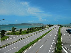
Uruma (うるま市, Uruma-shi) is a city located in Okinawa Prefecture, Japan.[2] The modern city of Uruma was established on April 1, 2005, when the cities of Gushikawa and Ishikawa were merged with the towns of Katsuren and Yonashiro (both from Nakagami District).[2][3] As of May 1, 2013, the city has an estimated population of 118,330 and a population density of 1,400 people per km2. The total area is 86.00 km2. The city covers part of the east coast of the south of Okinawa Island, the Katsuren Peninsula, and the eight Yokatsu Islands.[4] The Yokatsu Islands include numerous sites important to the Ryukyuan religion, and the city as a whole has numerous historical sites, including: Katsuren Castle, Agena Castle, and Iha Castle and the Iha Shell Mound.[2][3] It is home to the largest venue for Okinawan bullfighting. The Mid-Sea Road, which crosses the ocean and connects the Yokatsu Islands to the main island of Okinawa, is now a symbol of Uruma.[2][3][5]- [es] Uruma
[ru] Урума
Урума (яп. うるま市 Урума-си) — город в Японии, находящийся в префектуре Окинава. Площадь города составляет 86,08 км²[1], население — 118 491 человек (1 августа 2014)[2], плотность населения — 1376,52 чел./км².Текст в блоке "Читать" взят с сайта "Википедия" и доступен по лицензии Creative Commons Attribution-ShareAlike; в отдельных случаях могут действовать дополнительные условия.
Другой контент может иметь иную лицензию. Перед использованием материалов сайта WikiSort.org внимательно изучите правила лицензирования конкретных элементов наполнения сайта.
Другой контент может иметь иную лицензию. Перед использованием материалов сайта WikiSort.org внимательно изучите правила лицензирования конкретных элементов наполнения сайта.
2019-2026
WikiSort.org - проект по пересортировке и дополнению контента Википедии
WikiSort.org - проект по пересортировке и дополнению контента Википедии