world.wikisort.org - Japan
Takachiho (高千穂町, Takachiho-chō) is a town in Nishiusuki District, Miyazaki Prefecture, Japan. As of October 1, 2019, the town has an estimated population of 11,959 and a density of 50.3 persons per km². The total area is 237.54 km².
Takachiho
高千穂町 | |
|---|---|
Town | |
 Flag  Chapter | |
 Location of Takachiho in Miyazaki Prefecture | |
 Takachiho Location in Japan | |
| Coordinates: 32°43′N 131°18′E | |
| Country | Japan |
| Region | Kyushu |
| Prefecture | Miyazaki Prefecture |
| District | Nishiusuki |
| Government | |
| • Mayor | Shingo Uchikura (内倉信吾) |
| Area | |
| • Total | 237.54 km2 (91.71 sq mi) |
| Population (October 1, 2019) | |
| • Total | 11,959 |
| • Density | 50/km2 (130/sq mi) |
| Time zone | UTC+09:00 (JST) |
| City hall address | 13 Ōaza Mitai, Takachiho-chō, Nishiusuki-gun, Miyazaki-ken 882-1192 |
| Climate | Cfa |
| Website | www |
| Symbols | |
| Bird | Meadow bunting |
| Flower | Wisteria |
| Tree | Ogatama-no-ki |
Geography
Takachiho is in the northernmost part of Miyazaki Prefecture, bordering Kumamoto Prefecture on its north and northwest sides and Ōita Prefecture on its north and northeast sides. The Gokase River flows from the west to the southeast part of town.
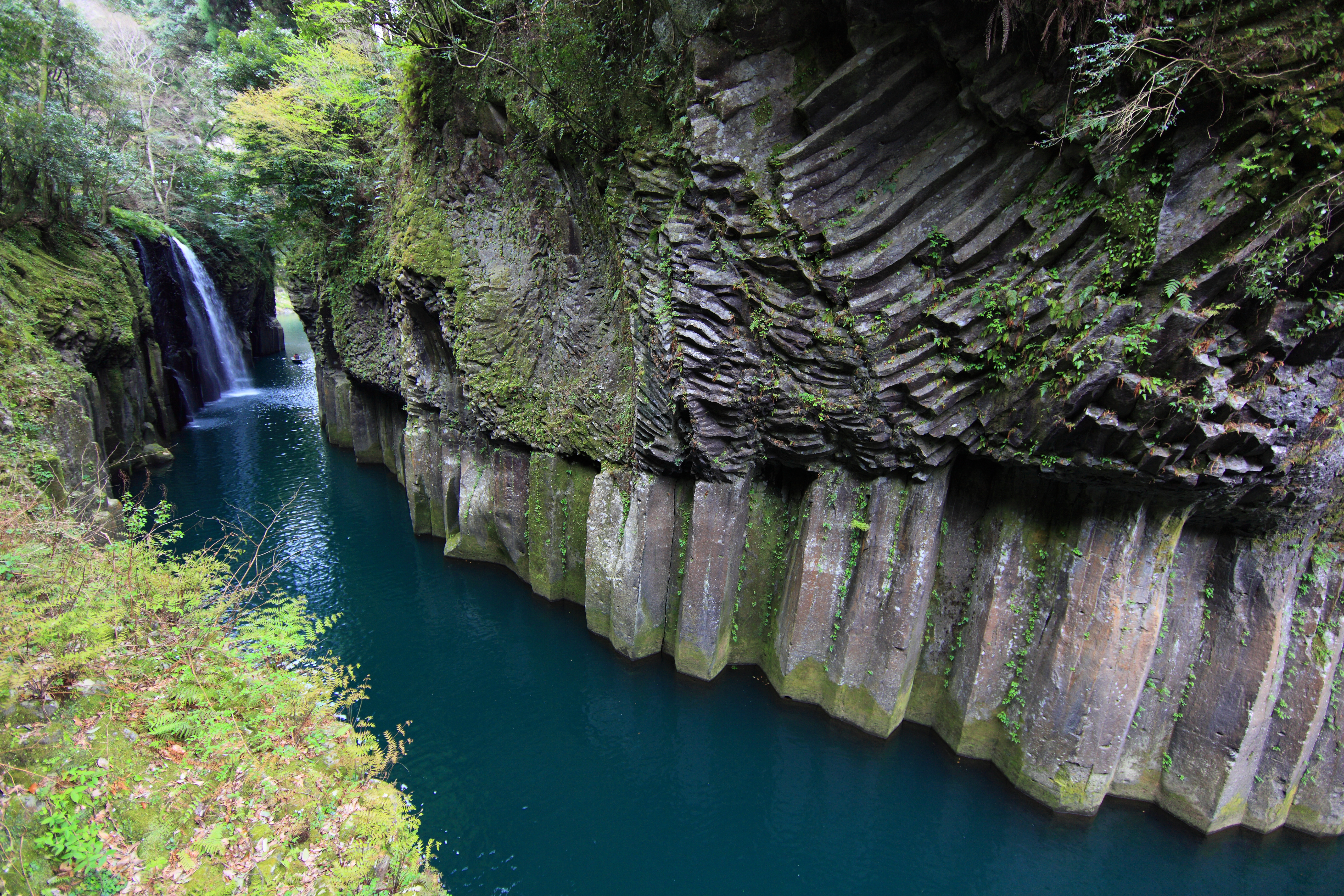
The heart of the town is at its center, around the now-defunct Takachiho Station and the business office of Takachiho Kotsu, the town's public transportation company. Takachiho Gorge, in the southern part of town, is fairly famous as a tourist attraction.
Takachiho is about 120 km northwest of the prefectural capital of Miyazaki and about 80 km southeast of the city of Kumamoto. Due to no public transportation facilities, nor any national highways to Miyazaki, it takes about three hours to get there.
Neighboring municipalities
- Miyazaki Prefecture
- Kumamoto Prefecture
- Ōita Prefecture
- Taketa
- Bungo-ōno
Climate
Takachiho has a humid subtropical climate (Köppen climate classification Cfa) with hot, humid summers and cool winters. The average annual temperature in Takachiho is 14.4 °C (57.9 °F). The average annual rainfall is 2,361.8 mm (92.98 in) with June as the wettest month. The temperatures are highest on average in August, at around 25.0 °C (77.0 °F), and lowest in January, at around 3.7 °C (38.7 °F).[1] The highest temperature ever recorded in Takachiho was 37.3 °C (99.1 °F) on 16 July 2006; the coldest temperature ever recorded was −11.1 °C (12.0 °F) on 19 February 1977.[2]
| Climate data for Takachiho (1991−2020 normals, extremes 1977−present) | |||||||||||||
|---|---|---|---|---|---|---|---|---|---|---|---|---|---|
| Month | Jan | Feb | Mar | Apr | May | Jun | Jul | Aug | Sep | Oct | Nov | Dec | Year |
| Record high °C (°F) | 20.4 (68.7) |
22.7 (72.9) |
27.8 (82.0) |
29.5 (85.1) |
33.0 (91.4) |
34.1 (93.4) |
37.3 (99.1) |
36.9 (98.4) |
35.1 (95.2) |
30.6 (87.1) |
28.0 (82.4) |
22.8 (73.0) |
37.3 (99.1) |
| Average high °C (°F) | 9.3 (48.7) |
11.1 (52.0) |
14.9 (58.8) |
20.0 (68.0) |
24.1 (75.4) |
26.0 (78.8) |
29.8 (85.6) |
30.6 (87.1) |
27.5 (81.5) |
22.8 (73.0) |
17.2 (63.0) |
11.5 (52.7) |
20.4 (68.7) |
| Daily mean °C (°F) | 3.7 (38.7) |
5.0 (41.0) |
8.4 (47.1) |
13.2 (55.8) |
17.6 (63.7) |
20.9 (69.6) |
24.7 (76.5) |
25.0 (77.0) |
21.8 (71.2) |
16.2 (61.2) |
10.6 (51.1) |
5.4 (41.7) |
14.4 (57.9) |
| Average low °C (°F) | −1.0 (30.2) |
−0.3 (31.5) |
2.7 (36.9) |
7.1 (44.8) |
12.0 (53.6) |
17.0 (62.6) |
21.1 (70.0) |
21.4 (70.5) |
17.6 (63.7) |
11.2 (52.2) |
5.3 (41.5) |
0.3 (32.5) |
9.5 (49.2) |
| Record low °C (°F) | −9.7 (14.5) |
−11.1 (12.0) |
−6.6 (20.1) |
−3.5 (25.7) |
0.5 (32.9) |
7.3 (45.1) |
11.1 (52.0) |
13.0 (55.4) |
5.5 (41.9) |
−0.4 (31.3) |
−3.7 (25.3) |
−8.2 (17.2) |
−11.1 (12.0) |
| Average precipitation mm (inches) | 59.7 (2.35) |
80.4 (3.17) |
121.9 (4.80) |
126.6 (4.98) |
164.2 (6.46) |
419.5 (16.52) |
403.1 (15.87) |
324.5 (12.78) |
380.7 (14.99) |
145.1 (5.71) |
78.2 (3.08) |
57.9 (2.28) |
2,361.8 (92.98) |
| Average precipitation days (≥ 1.0 mm) | 7.0 | 8.7 | 11.7 | 10.8 | 10.5 | 16.0 | 14.1 | 13.6 | 12.1 | 8.0 | 7.5 | 7.1 | 127.1 |
| Mean monthly sunshine hours | 131.3 | 135.8 | 161.3 | 180.3 | 177.8 | 116.7 | 154.3 | 170.8 | 143.8 | 160.6 | 138.7 | 137.7 | 1,809.2 |
| Source: Japan Meteorological Agency[2][1] | |||||||||||||
Demographics
Per Japanese census data, the population of Takachiho in 2020 is 11,642 people.[3] Takachiho has been conducting censuses since 1960.
| Year | Pop. | ±% |
|---|---|---|
| 1960 | 27,052 | — |
| 1965 | 24,757 | −8.5% |
| 1970 | 22,131 | −10.6% |
| 1975 | 20,523 | −7.3% |
| 1980 | 19,957 | −2.8% |
| 1985 | 19,170 | −3.9% |
| 1990 | 18,093 | −5.6% |
| 1995 | 16,780 | −7.3% |
| 2000 | 15,843 | −5.6% |
| 2005 | 14,778 | −6.7% |
| 2010 | 13,723 | −7.1% |
| 2015 | 12,755 | −7.1% |
| 2020 | 11,642 | −8.7% |
| Takachiho population statistics[3] | ||
History
During World War Two, the 2nd Raiding Brigade trained in the town and were sometimes known as the Takachiho paratroopers.[4]

Mythology
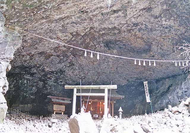
According to Japanese mythology, Takachiho is the land where Ninigi descended from the heavens, sent by Amaterasu, the sun goddess. It contains the Ama-no-Iwato shrine which is, according to myth, the location of the cave where Amaterasu hid until Ame-no-Uzume lured her out.
Education
Prefectural high schools
- Takachiho High School
Junior high schools
- Takachiho Junior High School
- Tabaru Junior High School
- Iwato Junior High School
- Kamino Junior High School
Elementary schools
- Takachiho Elementary School
- Oshikata Elementary School
- Tabaru Elementary School
- Iwato Elementary School
- Kamino Elementary School
Transportation
Air
The nearest airport is Kumamoto Airport.
Rail
- Takachiho Railway
- Takachiho Line (inactive)
- Ama-no-iwato Station - Takachiho Station
- Takachiho Line (inactive)
Road
- National highways
- Japan National Route 218
- Takachiho Roadside Station
- Japan National Route 325
- Japan National Route 218
Scenic and historic places
Takachiho is the heart of the Himuka Myth Road, which extends throughout Miyazaki.
- Takachiho Gorge
- Manai Waterfall
- Kunimigaoka
- Ama-no-iwato Jinja Shinto Shrine
- Shonenji Temple
- Takachiho Onsen
- Takachiho Shrine
References
- 気象庁 / 平年値(年・月ごとの値). JMA. Retrieved April 21, 2022.
- 観測史上1~10位の値(年間を通じての値). JMA. Retrieved April 21, 2022.
- Takachiho population statistics
- Prefer, Nathan N. (2012-12-07). Leyte, 1944: The Soldiers' Battle. Casemate. ISBN 978-1-61200-155-5.
External links
- Official website (in Japanese)
- Takachiho-cho Tourism Association (in English)
 Takachiho travel guide from Wikivoyage
 Geographic data related to Takachiho, Miyazaki at OpenStreetMap
Authority control | |
|---|---|
| General | |
| National libraries | |
| Scientific databases | |
| Other |
|
Miyazaki (capital) | |
| Core city |
|
| Cities | |
| Districts | |
List of mergers in Miyazaki Prefecture | |
This Miyazaki Prefecture location article is a stub. You can help Wikipedia by expanding it. |
На других языках
- [en] Takachiho, Miyazaki
[ru] Такатихо
Така́тихо (яп. 高千穂町 Такатихо-тё:) — посёлок в Японии, находящийся в уезде Нисиусуки префектуры Миядзаки. Площадь посёлка составляет 237,32 км²[1], население — 12 861 человек (1 августа 2014)[2], плотность населения — 54,19 чел./км².Другой контент может иметь иную лицензию. Перед использованием материалов сайта WikiSort.org внимательно изучите правила лицензирования конкретных элементов наполнения сайта.
WikiSort.org - проект по пересортировке и дополнению контента Википедии