world.wikisort.org - Japan
Okabe (岡部町, Okabe-chō) was a town located in Shida District, Shizuoka, Japan.
Okabe
岡部町 | |
|---|---|
Former municipality | |
 Flag  Seal | |
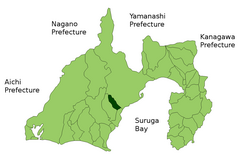 Location of Okabe in Shizuoka Prefecture | |
 Okabe Location in Japan | |
| Coordinates: 34°55′N 138°17′E | |
| Country | Japan |
| Region | Chūbu (Tōkai) |
| Prefecture | Shizuoka Prefecture |
| District | Shida |
| Merged | January 1, 2009 (now part of Fujieda, Shizuoka) |
| Area | |
| • Total | 53.29 km2 (20.58 sq mi) |
| Population (December 31, 2008) | |
| • Total | 12,210 |
| Time zone | UTC+09:00 (JST) |
| Website | City of Fujieda |
| Symbols | |
| Flower | Prunus Mume |
| Tree | Osmanthus |
Okabe developed in the Edo period as Okabe-juku, a post-town on the Tōkaidō.
As of 2003, the town had an estimated population of 12,839 and a density of 240.93 persons per km². The total area was 53.29 km². The town was served by an interchange on Japan National Route 1, but had no train service.
On January 1, 2009, Okabe was merged into the expanded city of Fujieda and thus no longer exists as an independent municipality. Shida District was dissolved as a result of the merger.[1][better source needed]
References
- "市町村合併情報 静岡県 <国土地理協会>". Archived from the original on July 28, 2007. Retrieved September 8, 2008.
This Shizuoka Prefecture location article is a stub. You can help Wikipedia by expanding it. |
Текст в блоке "Читать" взят с сайта "Википедия" и доступен по лицензии Creative Commons Attribution-ShareAlike; в отдельных случаях могут действовать дополнительные условия.
Другой контент может иметь иную лицензию. Перед использованием материалов сайта WikiSort.org внимательно изучите правила лицензирования конкретных элементов наполнения сайта.
Другой контент может иметь иную лицензию. Перед использованием материалов сайта WikiSort.org внимательно изучите правила лицензирования конкретных элементов наполнения сайта.
2019-2025
WikiSort.org - проект по пересортировке и дополнению контента Википедии
WikiSort.org - проект по пересортировке и дополнению контента Википедии