world.wikisort.org - Japan
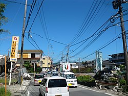
Mashiki (益城町, Mashiki-machi) is a town located in Kamimashiki District, Kumamoto Prefecture, Japan. As of March 2017, the town has an estimated population of 33,001[1] and a density of 500 persons per km². The total area is 65.67 km².
Mashiki
益城町 | |
|---|---|
Town | |
 Mashiki Town | |
 Location of Mashiki in Kumamoto Prefecture | |
 Mashiki Location in Japan | |
| Coordinates: 32°47′N 130°48′E | |
| Country | Japan |
| Region | Kyushu |
| Prefecture | Kumamoto Prefecture |
| District | Kamimashiki |
| Government | |
| • Mayor | Kōzaburou Suminaga |
| Area | |
| • Total | 65.67 km2 (25.36 sq mi) |
| Population (March 31, 2017) | |
| • Total | 33,001 |
| • Density | 500/km2 (1,300/sq mi) |
| Time zone | UTC+09:00 (JST) |
| Climate | Cfa |
| Website | www |
Kumamoto Airport is located in Mashiki.

Mashiki was near the epicenter of the 2016 Kumamoto earthquake, leading to fire and rubble killing at least 40 people.
Geography
Climate
| Climate data for Mashiki (2003−2020 normals, extremes 2003−present) | |||||||||||||
|---|---|---|---|---|---|---|---|---|---|---|---|---|---|
| Month | Jan | Feb | Mar | Apr | May | Jun | Jul | Aug | Sep | Oct | Nov | Dec | Year |
| Record high °C (°F) | 20.4 (68.7) |
23.3 (73.9) |
26.6 (79.9) |
28.9 (84.0) |
32.2 (90.0) |
33.8 (92.8) |
35.5 (95.9) |
37.3 (99.1) |
35.4 (95.7) |
32.5 (90.5) |
26.6 (79.9) |
23.0 (73.4) |
37.3 (99.1) |
| Average high °C (°F) | 9.6 (49.3) |
11.9 (53.4) |
15.4 (59.7) |
20.6 (69.1) |
25.2 (77.4) |
27.2 (81.0) |
30.6 (87.1) |
32.2 (90.0) |
29.1 (84.4) |
24.0 (75.2) |
18.0 (64.4) |
11.6 (52.9) |
21.3 (70.3) |
| Daily mean °C (°F) | 4.5 (40.1) |
6.3 (43.3) |
9.5 (49.1) |
14.5 (58.1) |
19.3 (66.7) |
22.5 (72.5) |
26.1 (79.0) |
27.0 (80.6) |
23.8 (74.8) |
18.3 (64.9) |
12.4 (54.3) |
6.5 (43.7) |
15.9 (60.6) |
| Average low °C (°F) | −0.6 (30.9) |
1.0 (33.8) |
3.6 (38.5) |
8.4 (47.1) |
13.7 (56.7) |
18.5 (65.3) |
22.5 (72.5) |
23.0 (73.4) |
19.6 (67.3) |
13.2 (55.8) |
7.3 (45.1) |
1.3 (34.3) |
11.0 (51.7) |
| Record low °C (°F) | −9.4 (15.1) |
−8.4 (16.9) |
−4.8 (23.4) |
−1.0 (30.2) |
3.7 (38.7) |
10.8 (51.4) |
16.3 (61.3) |
15.9 (60.6) |
11.2 (52.2) |
4.0 (39.2) |
−2.3 (27.9) |
−8.0 (17.6) |
−9.4 (15.1) |
| Average precipitation mm (inches) | 54.6 (2.15) |
106.1 (4.18) |
124.8 (4.91) |
148.3 (5.84) |
186.6 (7.35) |
443.7 (17.47) |
469.2 (18.47) |
195.6 (7.70) |
181.8 (7.16) |
98.9 (3.89) |
84.8 (3.34) |
67.4 (2.65) |
2,161.8 (85.11) |
| Average precipitation days (≥ 1.0 mm) | 6.1 | 9.1 | 10.1 | 10.0 | 9.6 | 15.2 | 14.2 | 11.6 | 10.1 | 7.2 | 7.8 | 7.6 | 118.6 |
| Source: JMA[2][3] | |||||||||||||
Notable People from Mashiki
- Minoru Hata, football player
- Shuhei Kamimura, football player
- Taishin Morikawa, football player
- Hiroki Noda, football player
- Ryota Sakata, football player
- Shintaro Shimada, football player
References
- "Official website of Mashiki Town" (in Japanese). Japan: Mashiki Town. Retrieved 1 May 2017.
- 観測史上1~10位の値(年間を通じての値). JMA. Retrieved February 27, 2022.
- 気象庁 / 平年値(年・月ごとの値). JMA. Retrieved February 27, 2022.
External links
 Media related to Mashiki, Kumamoto at Wikimedia Commons
- Mashiki official website (in Japanese)
На других языках
[de] Mashiki
Mashiki (jap. .mw-parser-output .Hani{font-size:110%}益城町, -machi) ist eine Stadt im Kamimashiki-gun in der japanischen Präfektur Kumamoto.- [en] Mashiki, Kumamoto
[ru] Масики
Масики (яп. 益城町 Масики-мати) — посёлок в Японии, находящийся в уезде Камимасики префектуры Кумамото. Площадь посёлка составляет 65,67 км²[1], население — 33 328 человек (1 августа 2014)[2], плотность населения — 507,51 чел./км². Здесь расположен аэропорт Кумамото.Текст в блоке "Читать" взят с сайта "Википедия" и доступен по лицензии Creative Commons Attribution-ShareAlike; в отдельных случаях могут действовать дополнительные условия.
Другой контент может иметь иную лицензию. Перед использованием материалов сайта WikiSort.org внимательно изучите правила лицензирования конкретных элементов наполнения сайта.
Другой контент может иметь иную лицензию. Перед использованием материалов сайта WikiSort.org внимательно изучите правила лицензирования конкретных элементов наполнения сайта.
2019-2025
WikiSort.org - проект по пересортировке и дополнению контента Википедии
WikiSort.org - проект по пересортировке и дополнению контента Википедии

