world.wikisort.org - Japan
Kōya (高野町, Kōya-chō) is a town located in Ito District, Wakayama Prefecture, Japan. As of 30 November 2021[update], the town had an estimated population of 2,812 in 1575 households and a population density of 21 persons per km².[1] The total area of the town is 137.03 square kilometres (52.91 sq mi). The town is known as the headquarters of the Shingon sect of Japanese Buddhism.
Kōya
高野町 | |
|---|---|
Town | |
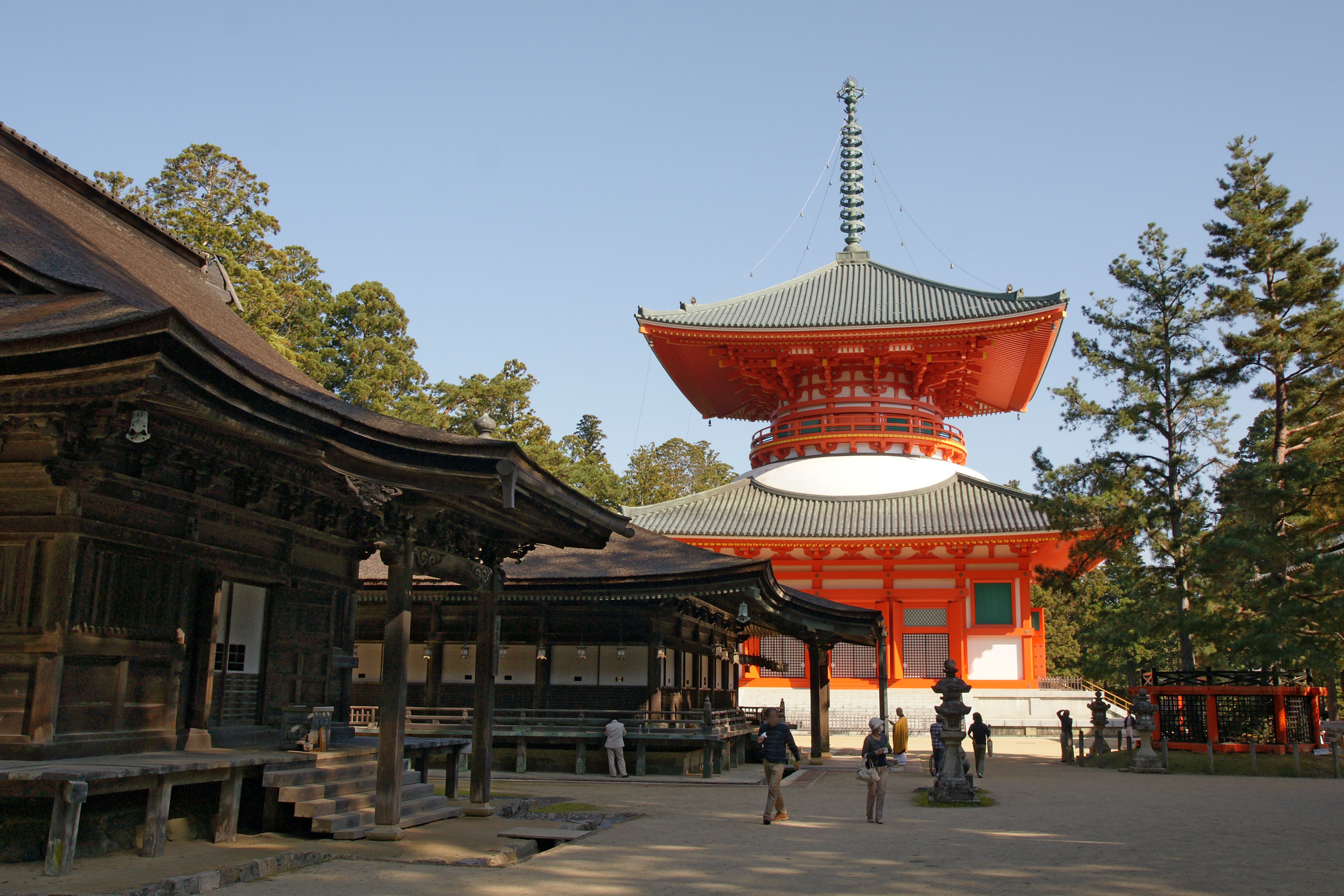 View of sightseeing of Mount Koya spot, with one of UNESCO World Heritage site | |
 Flag  Emblem | |
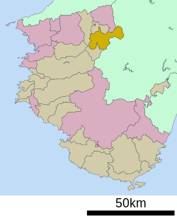 Location of Kōya in Wakayama Prefecture | |
 Kōya Location in Japan | |
| Coordinates: 34°13′N 135°35′E | |
| Country | Japan |
| Region | Kansai |
| Prefecture | Wakayama |
| District | Ito |
| Government | |
| • Mayor | Takeji Kise (since May 2010) |
| Area | |
| • Total | 137.03 km2 (52.91 sq mi) |
| Population (November 30, 2021) | |
| • Total | 2,812 |
| • Density | 21/km2 (53/sq mi) |
| Time zone | UTC+09:00 (JST) |
| City hall address | Oji Koyasan 636, Koya-cho, Ito-gun, Wakayama-ken 648-0281 |
| Climate | Cfa/Dfa |
| Website | Official website |
| Symbols | |
| Flower | Rhododendron |
| Tree | Sciadopitys verticillata |


Geography
Kōya is located near the prefectural border at the northeastern end of Wakayama Prefecture, on the heavily-forest plateau of Mount Koya
Neighbouring municipalities
Wakayama Prefecture
- Hashimoto
- Katsuragi
- Kudoyama
Nara Prefecture
Climate
Kōya has a Humid continental climate (Köppen Dfa/Cfa) characterized by warm summers and cool winters with light to no snowfall. The average annual temperature in Kōya is 11.1 °C (52.0 °F). The average annual rainfall is 2,003.1 °C (3,637.6 °F) with June as the wettest month. The temperatures are highest on average in August, at around 22.8 °C (73.0 °F), and lowest in January, at around −0.3 °C (31.5 °F).[2]
| Climate data for Mount Kōya, Kōya (1991−2020 normals, extremes 1979−present) | |||||||||||||
|---|---|---|---|---|---|---|---|---|---|---|---|---|---|
| Month | Jan | Feb | Mar | Apr | May | Jun | Jul | Aug | Sep | Oct | Nov | Dec | Year |
| Record high °C (°F) | 15.1 (59.2) |
17.9 (64.2) |
19.9 (67.8) |
26.5 (79.7) |
29.6 (85.3) |
30.8 (87.4) |
33.7 (92.7) |
33.2 (91.8) |
31.1 (88.0) |
27.2 (81.0) |
22.2 (72.0) |
19.7 (67.5) |
33.7 (92.7) |
| Average high °C (°F) | 3.4 (38.1) |
4.8 (40.6) |
9.2 (48.6) |
15.1 (59.2) |
20.1 (68.2) |
22.8 (73.0) |
26.6 (79.9) |
27.8 (82.0) |
23.7 (74.7) |
17.8 (64.0) |
12.2 (54.0) |
6.3 (43.3) |
15.8 (60.5) |
| Daily mean °C (°F) | −0.3 (31.5) |
0.4 (32.7) |
4.0 (39.2) |
9.4 (48.9) |
14.4 (57.9) |
18.1 (64.6) |
22.1 (71.8) |
22.8 (73.0) |
19.1 (66.4) |
13.2 (55.8) |
7.5 (45.5) |
2.2 (36.0) |
11.1 (51.9) |
| Average low °C (°F) | −4.0 (24.8) |
−3.8 (25.2) |
−1.0 (30.2) |
3.7 (38.7) |
8.9 (48.0) |
14.0 (57.2) |
18.4 (65.1) |
18.8 (65.8) |
15.3 (59.5) |
9.1 (48.4) |
3.0 (37.4) |
−1.6 (29.1) |
6.7 (44.1) |
| Record low °C (°F) | −12.8 (9.0) |
−13.4 (7.9) |
−9.4 (15.1) |
−5.1 (22.8) |
−1.4 (29.5) |
3.4 (38.1) |
9.9 (49.8) |
11.8 (53.2) |
5.0 (41.0) |
−1.5 (29.3) |
−5.0 (23.0) |
−10.0 (14.0) |
−13.4 (7.9) |
| Average precipitation mm (inches) | 87.6 (3.45) |
97.4 (3.83) |
141.7 (5.58) |
141.5 (5.57) |
166.6 (6.56) |
260.3 (10.25) |
256.4 (10.09) |
192.5 (7.58) |
247.5 (9.74) |
203.3 (8.00) |
108.4 (4.27) |
89.3 (3.52) |
2,003.1 (78.86) |
| Average precipitation days (≥ 1.0 mm) | 11.7 | 11.1 | 12.6 | 11.2 | 10.7 | 13.7 | 12.7 | 10.9 | 11.7 | 11.2 | 8.7 | 11.4 | 137.6 |
| Mean monthly sunshine hours | 82.9 | 96.7 | 138.5 | 176.5 | 185.5 | 124.9 | 146.1 | 166.8 | 124.7 | 130.6 | 115.6 | 93.0 | 1,582.3 |
| Source: Japan Meteorological Agency[3][2] | |||||||||||||
Demographics
Per Japanese census data,[4] the population of Kōya has declined steadily over the last 70 years.
| Year | Pop. | ±% |
|---|---|---|
| 1920 | 9,339 | — |
| 1930 | 10,821 | +15.9% |
| 1940 | 9,973 | −7.8% |
| 1950 | 9,786 | −1.9% |
| 1960 | 9,324 | −4.7% |
| 1970 | 7,604 | −18.4% |
| 1980 | 7,326 | −3.7% |
| 1990 | 6,611 | −9.8% |
| 2000 | 5,355 | −19.0% |
| 2010 | 3,979 | −25.7% |
History
The area of the modern town of Kōya was within ancient Kii Province and was long associated with the Shingon Buddhist temple complex on Mount Kōya, which was founded in 816AD. The village of Kōya was established with the creation of the modern municipalities system on April 1, 1889, and was raised to town status on November 1, 1918. The village of Fuki was annexed by Kōya on June 1, 1958
Government
Kōya has a mayor-council form of government with a directly elected mayor and a unicameral town council of 10 members. Kōya collectively with the town of Kudyama, contributes one member to the Wakayama Prefectural Assembly. In terms of national politics, the town is part of Wakayama 2nd district of the lower house of the Diet of Japan.
Economy
The economy of Kōya is centered on tourism. Since there are many temples, there are many people involved in Buddhist professions such as monks, and there are also many related tourism industry workers such as innkeepers, souvenir shops, and Buddhist equipment stores.
Education
Kōya has three public elementary schools and one public middle school operated by the town government, one public high school operated by the Wakayama Prefectural Board of Education. Koyasan University, a private university affiliated with Shingon Buddhism is located in the town.
Transportation
Railway
![]() Nankai Electric Railway – Nankai Kōya Line
Nankai Electric Railway – Nankai Kōya Line
- Kii-Hosokawa - Kii-Kamiya - Gokurakubashi
![]() Nankai Electric Railway – Nankai Cable Line
Nankai Electric Railway – Nankai Cable Line
- Gokurakubashi - Kōyasan
Highways
 National Route 370
 National Route 371
 National Route 480
Local attractions
- Sacred Sites and Pilgrimage Routes in the Kii Mountain Range
- Mount Kōya
- Kongōbu-ji
- Kongō Sanmai-in
- Koyasan Reihōkan
References
- "Kōya Town official statistics" (in Japanese). Japan.
- 気象庁 / 平年値(年・月ごとの値). JMA. Retrieved March 4, 2022.
- 観測史上1~10位の値(年間を通じての値). JMA. Retrieved March 4, 2022.
- Kōya population statistics
External links
 Media related to Kōya, Wakayama at Wikimedia Commons
- Kōya official website (in Japanese)
Authority control | |
|---|---|
| General | |
| National libraries | |
| Scientific databases | |
| Other |
|
Wakayama (capital) | ||
| Core city |
|  |
| Cities | ||
| Districts | ||
List of mergers in Wakayama Prefecture | ||
This Wakayama location article is a stub. You can help Wikipedia by expanding it. |
На других языках
- [en] Kōya, Wakayama
[ru] Коя
Коя (яп. 高野町 Ко:я-тё:) — посёлок в Японии, находящийся в уезде Ито префектуры Вакаяма. Площадь посёлка составляет 137,08 км²[1], население — 3510 человек (1 августа 2014)[2], плотность населения — 25,61 чел./км².Другой контент может иметь иную лицензию. Перед использованием материалов сайта WikiSort.org внимательно изучите правила лицензирования конкретных элементов наполнения сайта.
WikiSort.org - проект по пересортировке и дополнению контента Википедии