world.wikisort.org - Japan
Jinsekikōgen (神石高原町, Jinsekikōgen-chō) is a town located in Jinseki District, Hiroshima Prefecture, Japan.
Jinsekikōgen
神石高原町 | |
|---|---|
Town | |
 Jinsekikōgen town hall | |
 Flag  Emblem | |
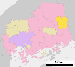
 Location of Jinsekikōgen in Hiroshima Prefecture | |
 Jinsekikōgen Location in Japan | |
| Coordinates: 34°42′N 133°15′E | |
| Country | Japan |
| Region | Chūgoku San'yō |
| Prefecture | Hiroshima Prefecture |
| District | Jinseki |
| Area | |
| • Total | 381.81 km2 (147.42 sq mi) |
| Population (May 1, 2017) | |
| • Total | 9,427 |
| • Density | 25/km2 (64/sq mi) |
| Time zone | UTC+09:00 (JST) |
| Climate | Cfa |
| Website | www |
Jinsekikōgen was created on November 5, 2004 from the merger of the towns of Jinseki, Yuki and Sanwa, and the village of Toyomatsu. Before Toyomatsu was incorporated, it was the last remaining village within Hiroshima Prefecture.[citation needed]
As of May 1, 2017 population data, the town has an estimated population of 9,427 and a density of 25 persons per km².[1] The total area is 381.81 km².
Geography
Climate
Jinsekikōgen has a humid subtropical climate (Köppen climate classification Cfa) characterized by cool to mild winters and hot, humid summers. The average annual temperature in Jinsekikōgen is 11.3 °C (52.3 °F). The average annual rainfall is 1,365.9 mm (53.78 in) with July as the wettest month. The temperatures are highest on average in August, at around 23.4 °C (74.1 °F), and lowest in January, at around 0.0 °C (32.0 °F).[2] The highest temperature ever recorded in Jinsekikōgen was 34.6 °C (94.3 °F) on 17 July 1994; the coldest temperature ever recorded was −16.3 °C (2.7 °F) on 28 February 1981.[3]
| Climate data for Yuki, Jinsekikōgen (1991−2020 normals, extremes 1978−present) | |||||||||||||
|---|---|---|---|---|---|---|---|---|---|---|---|---|---|
| Month | Jan | Feb | Mar | Apr | May | Jun | Jul | Aug | Sep | Oct | Nov | Dec | Year |
| Record high °C (°F) | 14.7 (58.5) |
18.7 (65.7) |
22.3 (72.1) |
28.3 (82.9) |
30.4 (86.7) |
32.1 (89.8) |
34.6 (94.3) |
34.0 (93.2) |
32.7 (90.9) |
27.7 (81.9) |
22.0 (71.6) |
17.4 (63.3) |
34.6 (94.3) |
| Average high °C (°F) | 4.7 (40.5) |
6.0 (42.8) |
10.5 (50.9) |
16.5 (61.7) |
21.4 (70.5) |
24.1 (75.4) |
27.6 (81.7) |
28.8 (83.8) |
24.7 (76.5) |
19.1 (66.4) |
13.3 (55.9) |
7.3 (45.1) |
17.0 (62.6) |
| Daily mean °C (°F) | 0.0 (32.0) |
0.7 (33.3) |
4.2 (39.6) |
9.8 (49.6) |
14.8 (58.6) |
18.8 (65.8) |
22.8 (73.0) |
23.4 (74.1) |
19.2 (66.6) |
12.9 (55.2) |
7.0 (44.6) |
2.0 (35.6) |
11.3 (52.3) |
| Average low °C (°F) | −4.2 (24.4) |
−4.1 (24.6) |
−1.7 (28.9) |
2.7 (36.9) |
8.1 (46.6) |
13.8 (56.8) |
18.7 (65.7) |
19.2 (66.6) |
14.7 (58.5) |
7.5 (45.5) |
1.6 (34.9) |
−2.4 (27.7) |
6.2 (43.1) |
| Record low °C (°F) | −13.4 (7.9) |
−16.3 (2.7) |
−10.9 (12.4) |
−6.6 (20.1) |
−3.0 (26.6) |
2.3 (36.1) |
7.9 (46.2) |
9.8 (49.6) |
0.8 (33.4) |
−3.6 (25.5) |
−5.9 (21.4) |
−11.3 (11.7) |
−16.3 (2.7) |
| Average precipitation mm (inches) | 46.5 (1.83) |
52.9 (2.08) |
96.6 (3.80) |
104.5 (4.11) |
137.1 (5.40) |
177.8 (7.00) |
225.5 (8.88) |
136.9 (5.39) |
170.7 (6.72) |
100.0 (3.94) |
65.0 (2.56) |
55.1 (2.17) |
1,365.9 (53.78) |
| Average precipitation days (≥ 1.0 mm) | 7.8 | 8.7 | 10.9 | 9.6 | 10.4 | 11.8 | 11.6 | 9.4 | 9.9 | 7.6 | 7.5 | 8.8 | 114 |
| Mean monthly sunshine hours | 107.8 | 119.0 | 165.6 | 191.2 | 210.5 | 153.1 | 156.2 | 187.8 | 146.8 | 168.8 | 140.0 | 118.4 | 1,867.8 |
| Source: Japan Meteorological Agency[2][3] | |||||||||||||
Demographics
Per Japanese census data, the population of Jinsekikōgen in 2020 is 8,250 people.[4] Jinsekikōgen has been conducting censuses since 1960.
| Year | Pop. | ±% |
|---|---|---|
| 1960 | 28,244 | — |
| 1965 | 23,297 | −17.5% |
| 1970 | 19,479 | −16.4% |
| 1975 | 17,114 | −12.1% |
| 1980 | 15,732 | −8.1% |
| 1985 | 14,834 | −5.7% |
| 1990 | 14,016 | −5.5% |
| 1995 | 13,218 | −5.7% |
| 2000 | 12,512 | −5.3% |
| 2005 | 11,590 | −7.4% |
| 2010 | 10,362 | −10.6% |
| 2015 | 9,217 | −11.0% |
| 2020 | 8,250 | −10.5% |
| Jinsekikōgen population statistics[4] | ||
References
- "Official website of Jinsekikōgen Town" (in Japanese). Japan: Jinsekikōgen Town. Retrieved 18 May 2017.
- 気象庁 / 平年値(年・月ごとの値). JMA. Retrieved May 10, 2022.
- 観測史上1~10位の値(年間を通じての値). JMA. Retrieved May 10, 2022.
- Jinsekikōgen population statistics
External links
 Media related to Jinsekikōgen, Hiroshima at Wikimedia Commons
- Jinsekikogen official website (in Japanese)
На других языках
- [en] Jinsekikōgen, Hiroshima
[ru] Дзинсекикоген
Дзинсекикоген (яп. 神石高原町 Дзинсэкико:гэн-тё:) — посёлок в Японии, находящийся в уезде Дзинсеки префектуры Хиросима. Площадь посёлка составляет 381,81 км²[1], население — 9426 человек (1 июля 2014)[2], плотность населения — 24,69 чел./км².Другой контент может иметь иную лицензию. Перед использованием материалов сайта WikiSort.org внимательно изучите правила лицензирования конкретных элементов наполнения сайта.
WikiSort.org - проект по пересортировке и дополнению контента Википедии