world.wikisort.org - Japan
Esashi (江刺市, Esashi-shi) was a city located in Iwate Prefecture, Japan. It is currently part of the city of Ōshū.
This article needs additional citations for verification. (September 2015) |
Esashi
江刺市 | |
|---|---|
Former municipality | |
 Esashi Fujiwara-no-sato | |
 Flag  Emblem | |
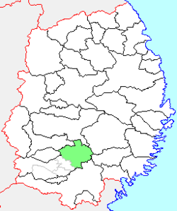 Location of Esashi in Iwate Prefecture | |
 Esashi Location in Japan | |
| Coordinates: 39°11′27.7″N 141°10′30.3″E | |
| Country | Japan |
| Region | Tōhoku |
| Prefecture | Iwate Prefecture |
| Merged | February 20, 2006 (now part of Ōshū) |
| Area | |
| • Total | 362.50 km2 (139.96 sq mi) |
| Population (September 1, 2005) | |
| • Total | 32,457 |
| • Density | 89.54/km2 (231.9/sq mi) |
| Time zone | UTC+09:00 (JST) |
| Climate | Cfa/Dfa |
| Symbols | |
| Bird | Common cuckoo |
| Flower | Sakura |
| Tree | Zelkova serrata |
Esashi village was created within Esashi District on April 1, 1899 with the establishment of the municipalities system. On February 10, 1955, it annexed the neighboring town of Iwayado and the villages of Inase, Atago, Tahara, Hirose, Sunagawa, Tamasato, Fujisato, Yonesato and Ide to form Esashi town. Esashi was raised to city status on November 3, 1958.
On February 20, 2006, Esashi, along with the city of Mizusawa, the towns of Isawa and Maesawa, and the village of Koromogawa (all from Isawa District), was merged to create the city of Ōshū, and no longer exists as an independent municipality.
As of February 2006, the city had an estimated population of 32,457 and a population density of 89.54 persons per km2. The total area was 362.50 km2.
Local attractions
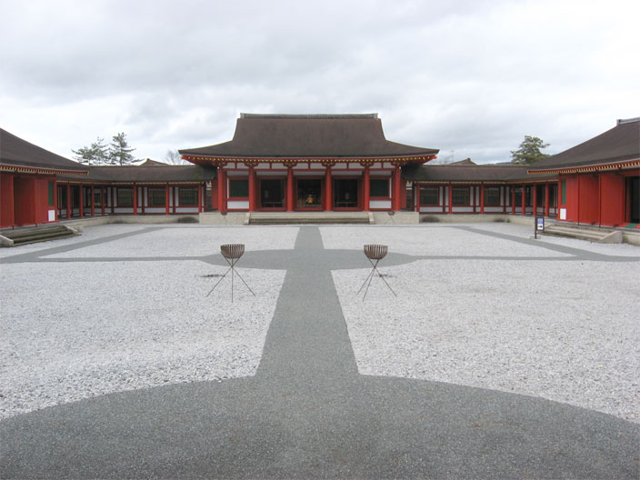
- Esashi contains a number of artifacts pertaining to the Northern Fujiwara clan, which dominated the Tohoku region in the Heian period. The Esashi Fujiwara no Sato is a theme park featuring buildings such as fortifications, palace structures, and government offices, which have been recreated to the past design.[1]
- Kurofune Square is a collection of black-and-white buildings. In style, these structures resemble storerooms. This feature of the design was chosen to impart uniformity to the stores housed in these buildings and to create a streetscape that would be unique to Esashi.
- Esashi Kinsatsumai is one of the most sought-after rice varieties in Japan.

Former international relations
 Australia - City of Greater Shepparton (Victoria, Australia) - sister city since March 3, 1979
 Austria - Reutte/Breitenwang (Tyrol, Austria) - sister city since June 7, 1991
Climate
| Climate data for Esashi, Iwate (1991−2020 normals, extremes 1976−present) | |||||||||||||
|---|---|---|---|---|---|---|---|---|---|---|---|---|---|
| Month | Jan | Feb | Mar | Apr | May | Jun | Jul | Aug | Sep | Oct | Nov | Dec | Year |
| Record high °C (°F) | 13.2 (55.8) |
16.9 (62.4) |
23.0 (73.4) |
29.3 (84.7) |
34.6 (94.3) |
34.8 (94.6) |
37.3 (99.1) |
37.3 (99.1) |
36.1 (97.0) |
29.4 (84.9) |
23.9 (75.0) |
20.0 (68.0) |
37.3 (99.1) |
| Average high °C (°F) | 2.5 (36.5) |
3.8 (38.8) |
8.5 (47.3) |
15.3 (59.5) |
21.0 (69.8) |
24.6 (76.3) |
27.6 (81.7) |
29.0 (84.2) |
25.1 (77.2) |
18.9 (66.0) |
11.9 (53.4) |
5.1 (41.2) |
16.1 (61.0) |
| Daily mean °C (°F) | −1.2 (29.8) |
−0.4 (31.3) |
3.3 (37.9) |
9.2 (48.6) |
15.1 (59.2) |
19.3 (66.7) |
22.8 (73.0) |
23.9 (75.0) |
19.8 (67.6) |
13.3 (55.9) |
6.7 (44.1) |
1.3 (34.3) |
11.1 (52.0) |
| Average low °C (°F) | −5.2 (22.6) |
−4.6 (23.7) |
−1.4 (29.5) |
3.4 (38.1) |
9.8 (49.6) |
15.0 (59.0) |
19.2 (66.6) |
20.1 (68.2) |
15.6 (60.1) |
8.4 (47.1) |
2.0 (35.6) |
−2.3 (27.9) |
6.7 (44.0) |
| Record low °C (°F) | −18.6 (−1.5) |
−18.9 (−2.0) |
−15.6 (3.9) |
−5.3 (22.5) |
−0.3 (31.5) |
5.8 (42.4) |
8.9 (48.0) |
10.8 (51.4) |
3.9 (39.0) |
−1.1 (30.0) |
−8.4 (16.9) |
−15.5 (4.1) |
−18.9 (−2.0) |
| Average precipitation mm (inches) | 57.3 (2.26) |
43.6 (1.72) |
71.4 (2.81) |
77.2 (3.04) |
98.0 (3.86) |
109.7 (4.32) |
168.9 (6.65) |
155.6 (6.13) |
149.7 (5.89) |
115.3 (4.54) |
72.2 (2.84) |
73.4 (2.89) |
1,194.1 (47.01) |
| Average precipitation days (≥ 1.0 mm) | 13.2 | 11.1 | 10.7 | 9.5 | 10.5 | 9.7 | 13.0 | 11.3 | 11.5 | 10.7 | 11.7 | 13.8 | 136.7 |
| Mean monthly sunshine hours | 95.9 | 111.5 | 155.5 | 178.8 | 187.8 | 154.6 | 132.0 | 149.7 | 126.2 | 130.5 | 113.5 | 89.0 | 1,630 |
| Source: JMA[2][3] | |||||||||||||
References
- "Esashi (Oshu City, Iwate Pref.)". Japan National Tourist Organization. Archived from the original on 2 January 2013. Retrieved 1 August 2013.
- 観測史上1~10位の値(年間を通じての値). JMA. Retrieved February 25, 2022.
- 気象庁 / 平年値(年・月ごとの値). JMA. Retrieved February 25, 2022.
External links
- Ōshū official website (in Japanese)
This Iwate Prefecture location article is a stub. You can help Wikipedia by expanding it. |
Другой контент может иметь иную лицензию. Перед использованием материалов сайта WikiSort.org внимательно изучите правила лицензирования конкретных элементов наполнения сайта.
WikiSort.org - проект по пересортировке и дополнению контента Википедии