world.wikisort.org - Irlanda
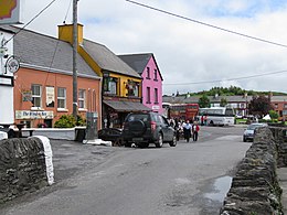
Sneem (in irlandese An tSnaidhm)[3] è un villaggio situato sulla penisola di Iveragh (parte del Ring of Kerry), nella contea di Kerry, nel sud-ovest dell'Irlanda. Si trova sull'estuario del fiume Sneem. La strada nazionale N70 attraversa la città.
| Sneem località | |
|---|---|
| (GA) An tSnaidhm | |
 | |
| Localizzazione | |
| Stato | |
| Provincia | |
| Contea | |
| Territorio | |
| Coordinate | 51°50′18.15″N 9°53′59.27″W |
| Abitanti | 288[2] (2016) |
| Altre informazioni | |
| Fuso orario | UTC+0 |
| Cartografia | |
Il villaggio si trova nell'area elettorale del Kerry meridionale e occidentale del Consiglio della contea di Kerry e nel collegio elettorale del Dáil Éireann di Kerry.
Origini del nome
Il nome del villaggio in irlandese An tSnaidhm significa "il nodo" in inglese. Sono state ipotizzate diverse spiegazioni del nome:
- Una è relativa al fatte che si dice che un vortice simile a un nodo abbia luogo dove il fiume Sneem incontra le correnti della baia di Kenmare nell'estuario, appena sotto il villaggio.
- Un'altra osserva che il villaggio di Sneem comprende due piazze, nord e sud. Un ponte al centro del paese, visto dall'alto, fa da nodo tra le due piazze.[4]
- Una spiegazione meno comune è che Sneem sia il nodo dello scenografico Ring of Kerry.
Storia
Un dizionario topografico dell'Irlanda, pubblicato da Samuel Lewis nel 1837, afferma che all'epoca Sneem consisteva in un porto, un insieme di case, una chiesa, una cappella e una "forza di polizia".[5]
L'ex presidente francese Charles de Gaulle visitò Sneem nel maggio 1969 e un monumento a lui dedicato si trova ora nella piazza nord del villaggio.[6]
Un libro, Sneem, The Knot in the Ring, racconta la storia della zona.[7] Nel 2000 è stata sepolta una capsula del tempo nel centro della città, che sarà aperta nel 2100.[8]
Note
- Sapmap Area - Settlements - Sneem, in Census 2016, Central Statistics Office, aprile 2016. URL consultato il 25 novembre 2020.
- [1]
- An tSnaidhm / Sneem, su logainm.ie, Irish Placenames Commission. URL consultato il 25 novembre 2020.
- Stoakley, T. E., Sneem: the knot in the ring, 2nd and enl.ª ed., Sneem, Co. Kerry, Sneem Tourism Association, 1986, ISBN 0951163000, OCLC 18192375.
- Samuel Lewis, A Topographical Dictionary of Ireland, S. Lewis and Co., 1837.
- (EN) Anne Lucey, 50th anniversary of visit by Charles de Gaulle to be marked in Co Kerry, su Irish Examiner, 7 giugno 2019. URL consultato il 25 novembre 2020.
- T.E. Stoakley, Sneem: The Knot in the Ring, Sneem, Co. Kerry, Sneem Tourism Association, 1986, ISBN 0-9511630-0-0.
- Joe Cashin, To be opened in 2100, su PhotoFrom.com, 12 ottobre 2005. URL consultato il 13 febbraio 2007 (archiviato dall'url originale il 29 settembre 2007).
Voci correlate
- Centri abitati dell'Irlanda
Altri progetti
 Wikimedia Commons contiene immagini o altri file su Sneem
Collegamenti esterni
- Sneem.com – portale web del villaggio
- Sneem.ie – sito web della comunità
- Le città ordinate d'Irlanda "Celebrano 50 anni"
| Controllo di autorità | VIAF (EN) 150195109 · LCCN (EN) n87917970 · J9U (EN, HE) 987007562564305171 · WorldCat Identities (EN) lccn-n87917970 |
|---|
На других языках
[en] Sneem
Sneem (Irish: An tSnaidhm)[2] is a village situated on the Iveragh Peninsula (part of the Ring of Kerry), in County Kerry, in the southwest of Ireland. It lies on the estuary of the River Sneem. National route N70 runs through the town. While the 2016 census recorded a population of 288 people,[1] Sneem is located in tourist area and the population increases during the summer months.[3]- [it] Sneem
[ru] Сним
Сним[2] (англ. Sneem; ирл. An tSnaidhm) — деревня в Ирландии, находится в графстве Керри (провинция Манстер). В 1987 году деревня выигрывала Irish Tidy Towns Competition[3].Другой контент может иметь иную лицензию. Перед использованием материалов сайта WikiSort.org внимательно изучите правила лицензирования конкретных элементов наполнения сайта.
WikiSort.org - проект по пересортировке и дополнению контента Википедии

