world.wikisort.org - Irland
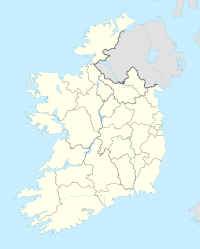
Borrisokane (irisch: Buiríos Uí Chéin) ist ein Ort im Norden der Grafschaft Tipperary in der Republik Irland.
| Borrisokane Buiríos Uí Chéin Borrisokane | ||
|---|---|---|
|
| ||
| Koordinaten | 52° 59′ N, 8° 8′ W | |
| Basisdaten | ||
| Staat | Irland | |
|
Provinz |
Munster | |
| Grafschaft | Tipperary | |
| ISO 3166-2 | IE-TA | |
| Einwohner | 942 (2016[1]) | |
Der Ort hatte 2016 etwa 942 Einwohner.[1] Er liegt an der Nationalstraße N52 zwischen Nenagh und Birr, etwas südlich der Abzweigung der N65 nach Portumna.[2] Borrisokane ist nur 12 km vom Lough Derg entfernt.
Prominente Bürger
- James McGolrick (1841–1918), römisch-katholischer Bischof
- Frank Corcoran (* 1944), Komponist
Einzelnachweise
- Census 2016. citypopulation.de, abgerufen am 18. Oktober 2020.
- Karte von Irland. (jpg-Datei) In: ireland-information.com. Abgerufen am 18. Oktober 2022.
На других языках
- [de] Borrisokane
[en] Borrisokane
Borrisokane (Irish: Buiríos Uí Chéin, meaning 'the burgage of the Cianacht')[2] is a town in County Tipperary, Ireland. It is situated at the junction of the N52 and N65 national secondary roads. At the 2016 census, it had a population of 942.[1] The Ballyfinboy River flows through the town on its way to Lough Derg, 12 km (7 mi) to the west. It is also a civil parish in the historical barony of Ormond Lower and an Ecclesiastical parish in the Roman Catholic Diocese of Killaloe.[3][ru] Боррайсокен
Боррайсокен[2] (англ. Borrisokane; ирл. Buiríos Uí Chéin) — деревня в Ирландии, находится в графстве Северный Типперэри (провинция Манстер) у трасс N52 и N65.Текст в блоке "Читать" взят с сайта "Википедия" и доступен по лицензии Creative Commons Attribution-ShareAlike; в отдельных случаях могут действовать дополнительные условия.
Другой контент может иметь иную лицензию. Перед использованием материалов сайта WikiSort.org внимательно изучите правила лицензирования конкретных элементов наполнения сайта.
Другой контент может иметь иную лицензию. Перед использованием материалов сайта WikiSort.org внимательно изучите правила лицензирования конкретных элементов наполнения сайта.
2019-2025
WikiSort.org - проект по пересортировке и дополнению контента Википедии
WikiSort.org - проект по пересортировке и дополнению контента Википедии
