world.wikisort.org - Iran
Semnan Province (Persian: استان سمنان, Ôstâň-e Śemnân) is one of the 31 provinces of Iran. It is in the north of the country, and its center is Semnan. The province of Semnan covers an area of 96,816 square kilometers and stretches along the Alborz mountain range and borders to Dasht-e Kavir desert in its southern parts.
Semnan Province
استان سمنان | |
|---|---|
Province | |
 The entrance of Bayazid Shrine | |
 Semnan counties | |
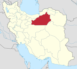 Location of Semnan Province in Iran | |
| Coordinates: 35.5769°N 53.3953°E | |
| Country | Iran |
| Region | Region 1[1] |
| Capital | Semnan |
| Counties | 8 |
| Government | |
| • Governor-general | Mohammad-Reza Hashemi |
| Area | |
| • Total | 97,491 km2 (37,641 sq mi) |
| Population (2011)[2] | |
| • Total | 631,218 |
| • Density | 6.5/km2 (17/sq mi) |
| Time zone | UTC+03:30 (IRST) |
| • Summer (DST) | UTC+04:30 (IRST) |
| ISO 3166 code | IR-20 |
| Main language(s) | Semnani languages, Persian |
| HDI (2017) | 0.822[3] very high · 6th |
The province was made part of Region 1 following the division of the provinces into 5 regions, solely for coordination and development purposes, on June 22, 2014.[1]
Counties of the province include Semnan County, Aradan County, Damghan County, Shahrud County, Mehdishahr County, Meyami County, Sorkheh County& Garmsar County. In 1996, the province had a population of about 501,000 (631,218 in 2011[2]), and in 2005 the city of Semnan (the capital of the province) had a population of 119,778, while the city of Shahrud, which is actually the largest city of this province, had a population of 231,831.
Geography
The province is divided into two parts: a mountainous region and the plains at the foot of the mountains. The former offers scope for recreational activities as well as being a source for minerals, while the latter encompasses some ancient cities of Iran, including one of the capitals of the ancient Parthian Empire.
The province neighbors Golestan and Mazandaran to the north, North Khorasan to the northeast, Tehran and Qom to the west, Isfahan to the south, South Khorasan to the southeast, and Razavi Khorasan to the east.
Abr forest
This forest lies in the central province of Semnan, near its border with Golestan Province. It is one of the oldest forests in Iran which is a remnant of the third geological age. The Iranian Roads Ministry's decision to build a road through the forest sparked widespread protests last year.[when?]
The environmentalists, backed by the country's media, began a wide campaign against the ministry's decision, which finally led the Prosecutor General to order a halt in the construction of the road. However, all these efforts came to naught when it was announced in April 2008 that the government granted permission to the Roads Ministry to construct the road.[citation needed]

Languages
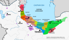
The Semnani languages (known also as Komisenian languages) spoken in the province are a group of Northwestern Iranian languages,[4] (only 68,700 native speakers in 2019[5]) of Iran. These languages are accorded only "dialect" status in some sources. Most of the Semnani languages are descendants of the extinct Parthian while Semnani proper has been placed among the Caspian languages descended from the extinct Median.[6]
There are six Semnani languages named in the literature, these being Semnani, Biyabunaki, Sangsari, Sorkhei, Aftari and Lasgerdi - of which some may only be dialects, although there has been little published concerning the relationships between them.[7]
Semnani proper (Semnani: سمنی زفون), like other Caspian languages, bears some resemblance to the Old Iranian Median language but was influenced by Parthian in a later process. [8]
Administrative divisions
This section's factual accuracy may be compromised due to out-of-date information. (May 2013) |
| Map | Shahrestan | Map Key | Bakhsh | Center |
|---|---|---|---|---|
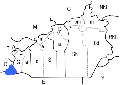 | ||||
| Damghan | D | Central | Damghan | |
| a | Amir Abad | |||
| Garmsar | G | Central | Garmsar | |
| a | Aradan | |||
| e | Eyvanakey | |||
| Mehdishahr | m | Central | Mehdishahr | |
| Shahmirzad | ||||
| Semnan | S | Central | Semnan | |
| s | Sorkheh | |||
| Shahrud | Sh | Central | Shahrud | |
| bd | Biarjmand | |||
| bm | Mayami | |||
| m | Bastam | |||
| Neighbor Provinces: E: Esfahan, G: Golestan, M: Mazandaran, NKh: North Khorasan, Q: Qom, RKh: Razavi Khorasan,
SKh: South Khorasan, T: Tehran | ||||
History
Semnan can be divided into sixteen sectors from the old days of Avesta. In the Median and Achaemenid times, it accounted for being one of the largest provinces of the empires, and today it roughly corresponds to the borders of the ancient region of Parthia.
During the Islamic era, Semnan was part of the historical region of Gomess or Komesh, and the Silk Road paved its way from the midst of this region. Needless to say, the province was witness to numerous wars.
The Cultural Historical Heritage Organization of Iran lists 470 sites of historical and cultural heritage such as palaces, forts, castles, caravansarais, ab anbars, and badgirs in Semnan. In addition to these, there are various religious and sacred places as well.
See also
- Bayazid Bastami
- Ashraf Jahangir Semnani
- Darius III
- Dasht-e Kavir
- Fath Ali Shah Qajar
- Hassan Rouhani
- Hecatompylos or Shahr-e Qumis
- Khar Turan National Park
- Mahmud Ahmadinejad
- Manuchehri Damghani
- Parthia
- Rig-e Jenn
- Sangsar (Mahdishahr)
- Seleucids
- Semnani language
- Yadollah Royaee
References
- همشهری آنلاین-استانهای کشور به ۵ منطقه تقسیم شدند
- Selected findings of National Population and Housing Census 2011 Archived May 31, 2013, at the Wayback Machine
- "Sub-national HDI - Area Database - Global Data Lab". hdi.globaldatalab.org. Retrieved 2018-09-13.
- Ethnologue listing for Semnani languages
- "Semnani".
- Pierre Lecoq. 1989. "Les dialectes caspiens et les dialectes du nord-ouest de l'Iran," Compendium Linguarum Iranicarum. Ed. Rüdiger Schmitt. Wiesbaden: Dr. Ludwig Reichert Verlag. pg. 297
- C.F. & F.M. Voegelin, Classification and Index of the World's Languages (1977) lists them as dialects of Persian (pg. 185).
Lecoq, pg. 297 lists them as "dialects" as well.
Ethnologue lists Semnani, Sorkhei, Lasgerdi, and Sangsari as languages with Biyabunaki as a possible dialect of Semnani and Aftari as a dialect of Sorkhei.
Linguasphere lists them together in an outer language called Semnani+Sangisari [58-AAC-f] with Semnani and Sangisari listed as inner languages.
Merritt Ruhlen, A Guide to the World's Languages, Volume 1: Classification (1991) lists Semnani and Sangisari as languages in the Semnani subgroup. - Habib Borjian: . In: . Nr. 2. Brill, 2009
External links
- History of Semnan Province
- Information on Semnan National geoscience database of Iran
- Semnan Cultural Heritage Organization
- SemnanLine NEWSPORTAL
- Chisholm, Hugh, ed. (1911). . Encyclopædia Britannica (11th ed.). Cambridge University Press.
Places adjacent to Semnan province | ||||||||||||||||
|---|---|---|---|---|---|---|---|---|---|---|---|---|---|---|---|---|
| ||||||||||||||||
| Capital |  | ||||||||||||||||
|---|---|---|---|---|---|---|---|---|---|---|---|---|---|---|---|---|---|
| Counties and cities |
| ||||||||||||||||
| Sights |
| ||||||||||||||||
| populated places |
| ||||||||||||||||
Provinces of Iran | ||
|---|---|---|
| ||
| Authority control: National libraries |
|---|
Другой контент может иметь иную лицензию. Перед использованием материалов сайта WikiSort.org внимательно изучите правила лицензирования конкретных элементов наполнения сайта.
WikiSort.org - проект по пересортировке и дополнению контента Википедии