world.wikisort.org - Iran
Kohgiluyeh and Boyer-Ahmad Province (Persian: استان کهگیلویه و بویراحمد, Ostān-e Kohgīlūye va Būyer-Ahmad ) (Luri: استان کهگیلویه و بِیرَمَد, Ostān-e Kohgīlūya-vo Beyramad) is one of the thirty-one provinces of Iran. It is in the south-west of the country, in Iran's Region 2,[3] and its capital is Yasuj. The province covers an area of 15,563 square kilometers, and in 2006 had a population of 634,000. According to the National Population and Housing Census, the population of Kohgiluyeh and Boyer-Ahmad in 2011 was 658,629.[1] The people mainly speak the Luri language. The counties of Kohgiluyeh and Boyer-Ahmad Province are Bahmai County, Landeh County, Boyer-Ahmad County, Charam County, Dana County, Basht County and Gachsaran County.
Kohgiluyeh and Boyer-Ahmad Province
استان کهگیلویه و بویراحمد | |
|---|---|
Province | |
| Kohgiluyeh & Boyer-Ahmad | |
 Location of Kohgiluyeh and Boyer-Ahmad within Iran | |
| Coordinates: 30.67°N 51.60°E | |
| Country | Iran |
| Region | Region 2 |
| Capital | Yasuj |
| Counties | 9 |
| Government | |
| • Governor-general | Ali Ahmadzadeh |
| Area | |
| • Total | 15,504 km2 (5,986 sq mi) |
| Population (2011)[1] | |
| • Total | 658,629 |
| • Density | 42/km2 (110/sq mi) |
| Time zone | UTC+03:30 (IRST) |
| • Summer (DST) | UTC+04:30 (IRST) |
| Main language(s) | Official: Persian Majority:Lurish |
| HDI (2017) | 0.796[2] high · 16th |
Location
Kohgiluyeh and Boyer-Ahmad Province is located in the south of Iran, and shares borders with five provinces: Isfahan and Fars provinces to the east, Bushehr province to the south, Khuzestan to the west and Chaharmahal and Bakhtiari to the north.
Geography
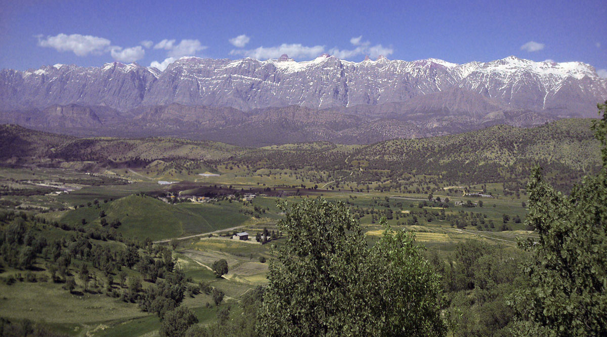

The province is mostly mountainous in terrain, part of the Zagros range. The highest point is the Dena summit with a height of 5,109 metres.
The mountain range of Dena, which reaches an elevation of 4,000 metres, is located in the province, and is covered with oak forests. Another mountain is Khamin or Khami, which is located in Gachsaran country.
Administrative divisions
 Counties of Kohgiluyeh and Boyer-Ahmad Province
 Cities of Kohgiluyeh and Boyer-Ahmad Province


The province is divided into nine counties and 16 districts, which include 16 cities and more than 1,700 villages.
| County | Capital |
|---|---|
| Boyer-Ahmad County | Yasuj |
| Bahmai County | Likak |
| Dana County | Sisakht |
| Kohgiluyeh County | Dehdasht |
| Gachsaran County | Dogonbadan |
| Charam County | Charam |
| Basht County | Basht |
| Landeh County | Landeh |
| Margown County | Margown |
Colleges and universities
See also
- Seyyed Nasir Hosseini (the representative of Guardianship of the Islamic Jurist, in the province)
References
- Selected Findings of the 2011 National Population and Housing Census Archived 2014-11-14 at the Wayback Machine
- "Sub-national HDI - Area Database - Global Data Lab". hdi.globaldatalab.org. Retrieved 2018-09-13.
- "همشهری آنلاین-استانهای کشور به ۵ منطقه تقسیم شدند (Provinces were divided into 5 regions)". Hamshahri Online (in Persian). 22 June 2014. Archived from the original on 23 June 2014.
External links
- Official website of Kohgiluyeh and Buyer Ahmad Governorship
- A Boyer-Ahmad-i folk-song sung by Shusha Guppy in the 1970s: Girl from Boyer-Ahmad-i Tribe.
Places adjacent to Kohgiluyeh and Boyer-Ahmad province | ||||||||||||||||
|---|---|---|---|---|---|---|---|---|---|---|---|---|---|---|---|---|
| ||||||||||||||||
| Capital |  | ||||||||||||||||||
|---|---|---|---|---|---|---|---|---|---|---|---|---|---|---|---|---|---|---|---|
| Counties and cities |
| ||||||||||||||||||
| Sights |
| ||||||||||||||||||
| populated places |
| ||||||||||||||||||
Provinces of Iran | ||
|---|---|---|
| ||
| Authority control: National libraries |
|---|
Другой контент может иметь иную лицензию. Перед использованием материалов сайта WikiSort.org внимательно изучите правила лицензирования конкретных элементов наполнения сайта.
WikiSort.org - проект по пересортировке и дополнению контента Википедии