world.wikisort.org - Indonesia
Rangkasbitung (Sundanese: ᮛᮀᮊᮞ᮪ᮘᮤᮒᮥᮀ) (colloquially called Rangkas) is a town which is the administrative centre of Lebak Regency, in Banten Province of Java, Indonesia. It had a population of 134,945 at the 2020 Census, while the official estimate as at mid 2021 was 137,041.[2]
This article needs additional citations for verification. (March 2014) |
This article has an unclear citation style. (April 2012) |
Rangkasbitung
(Rangkasbitung Town) (Kecamatan Rangkasbitung) | |
|---|---|
City | |
| Other transcription(s) | |
| • Sundanese | ᮛᮀᮊᮞ᮪ᮘᮤᮒᮥᮀ |
| • Jawi | راڠكاسبيتوڠ |
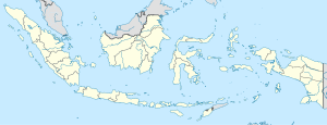 Rangkasbitung Location of Rangkasbitung in Indonesia | |
| Coordinates: 6°7′12″S 106°9′1″E | |
| Country | |
| Province | |
| Regency | Lebak Regency |
| Government | |
| • Camat | Agus Sudrajat, S.Sos., M.Si. |
| Area | |
| • Total | 73.10 km2 (28.22 sq mi) |
| Population (mid 2021 estimate) | |
| • Total | 137,041 |
| • Density | 1,900/km2 (4,900/sq mi) |
| [1] | |
| Time zone | UTC+7 (WIB) |
| Area code | +62 252 |
| Website | rangkasbitung |
It is the site of the Multatuli Museum, a history museum which opened in 2018.
Climate
Rangkasbitung has a tropical rainforest climate (Af) with heavy rainfall year-round.
| Climate data for Rangkasbitung | |||||||||||||
|---|---|---|---|---|---|---|---|---|---|---|---|---|---|
| Month | Jan | Feb | Mar | Apr | May | Jun | Jul | Aug | Sep | Oct | Nov | Dec | Year |
| Average high °C (°F) | 30.7 (87.3) |
31.1 (88.0) |
31.6 (88.9) |
32.2 (90.0) |
32.5 (90.5) |
32.4 (90.3) |
32.5 (90.5) |
32.6 (90.7) |
33.0 (91.4) |
33.1 (91.6) |
32.6 (90.7) |
31.9 (89.4) |
32.2 (89.9) |
| Daily mean °C (°F) | 26.7 (80.1) |
27.0 (80.6) |
27.2 (81.0) |
27.5 (81.5) |
27.7 (81.9) |
27.3 (81.1) |
27.1 (80.8) |
27.0 (80.6) |
27.5 (81.5) |
27.8 (82.0) |
27.7 (81.9) |
27.4 (81.3) |
27.3 (81.2) |
| Average low °C (°F) | 22.8 (73.0) |
22.9 (73.2) |
22.8 (73.0) |
22.9 (73.2) |
23.0 (73.4) |
22.3 (72.1) |
21.8 (71.2) |
21.5 (70.7) |
22.0 (71.6) |
22.5 (72.5) |
22.9 (73.2) |
23.0 (73.4) |
22.5 (72.5) |
| Average rainfall mm (inches) | 321 (12.6) |
245 (9.6) |
242 (9.5) |
219 (8.6) |
184 (7.2) |
113 (4.4) |
136 (5.4) |
144 (5.7) |
144 (5.7) |
182 (7.2) |
190 (7.5) |
219 (8.6) |
2,339 (92) |
| Source: Climate-Data.org[3] | |||||||||||||
Transportation
The town lies on the road connecting Jakarta, Serpong and Pandeglang. It is also connected with western railway line of Java, connecting Jakarta with Serang until Merak. The town is served by Jakarta Metrorail.
Notable residents
- Eduard Douwes Dekker or Multatuli, the author of Max Havelaar, once lived and worked in the town. His experience and observation during his time here triggered him to write the famous romance.
- Eugenia van Beers, the mother of American rock musicians Eddie van Halen and Alex van Halen was born in this town.[4]
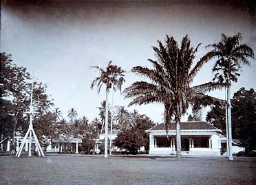 House of assistant-resident of Lebak in Rangkasbitung, where Eduard Douwes Dekker once lived.
 The Ciberang and Ciujung rivers coming together at Rangkasbitung


References
- Badan Pusat Statistik, Jakarta, 2022.
- Badan Pusat Statistik, Jakarta, 2022.
- "Climate: Rangkasbitung". Climate-Data.org. Retrieved 12 November 2020.
- Archived at Ghostarchive and the Wayback Machine: Van Halen Interview. YouTube.
Текст в блоке "Читать" взят с сайта "Википедия" и доступен по лицензии Creative Commons Attribution-ShareAlike; в отдельных случаях могут действовать дополнительные условия.
Другой контент может иметь иную лицензию. Перед использованием материалов сайта WikiSort.org внимательно изучите правила лицензирования конкретных элементов наполнения сайта.
Другой контент может иметь иную лицензию. Перед использованием материалов сайта WikiSort.org внимательно изучите правила лицензирования конкретных элементов наполнения сайта.
2019-2026
WikiSort.org - проект по пересортировке и дополнению контента Википедии
WikiSort.org - проект по пересортировке и дополнению контента Википедии