world.wikisort.org - India
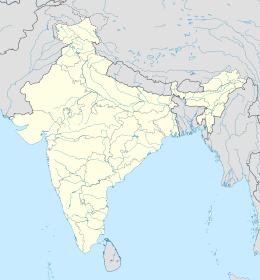
Kolhapur è una suddivisione dell'India, classificata come municipal corporation, di 485 183 abitanti, capoluogo del distretto di Kolhapur, nello stato federato del Maharashtra. In base al numero di abitanti la città rientra nella classe I (da 100 000 persone in su).[4]
| Kolhapur Corporazione Municipale (Municipal Corporation) | |
|---|---|
 | |
| Localizzazione | |
| Stato | |
| Stato federato | Maharashtra |
| Divisione | Pune |
| Distretto | Kolhapur |
| Amministrazione | |
| Sindaco | Uday Salokhe |
| Territorio | |
| Coordinate | 16°42′N 74°14′E |
| Altitudine | 544[1] m s.l.m. |
| Superficie | 66,82 km² |
| Abitanti | 485 183 (2001) |
| Densità | 7 261,04 ab./km² |
| Altre informazioni | |
| Lingue | marathi, inglese |
| Cod. postale | 416003[2] |
| Prefisso | 231[3] |
| Fuso orario | UTC+5:30 |
| Targa | MH-09 |
| Cartografia | |
Geografia fisica
La città è situata a 16° 41' 60 N e 74° 13' 0 E e ha un'altitudine di 544 m s.l.m.[1]
Società
Evoluzione demografica
Al censimento del 2001 la popolazione di Kolhapur assommava a 485 183 persone, delle quali 251 958 maschi e 233 225 femmine. I bambini di età inferiore o uguale ai sei anni assommavano a 50 136, dei quali 27 628 maschi e 22 508 femmine. Infine, coloro che erano in grado di saper almeno leggere e scrivere erano 386 256, dei quali 211 392 maschi e 174 864 femmine.[5]
Note
- (EN) Falling Rain Genomics, Inc, Kolhapur, India Page, su fallingrain.com. URL consultato l'11 luglio 2008.
- (EN) India Post, Pincode search - Kolhapur [collegamento interrotto], su indiapost.gov.in. URL consultato il 28 luglio 2008.
- (EN) Bharat Sanchar Nigam Ltd, STD Codes for cities in Maharashtra, su bsnl.co.in. URL consultato il 28 luglio 2008 (archiviato dall'url originale il 28 maggio 2008).
- (EN) Census of India, Alphabetical list of towns and their population - Maharashtra (PDF), su censusindia.gov.in. URL consultato il 21 maggio 2008.
- (EN) Census of India 2001, Population, population in the age group 0-6 and literates by sex - Cities/Towns (in alphabetic order): 2001, su censusindia.net. URL consultato il 20 giugno 2008 (archiviato dall'url originale il 16 giugno 2004).
Altri progetti
 Wikimedia Commons contiene immagini o altri file su Kolhapur
Collegamenti esterni
- Kolhapur (città), su sapere.it, De Agostini.
- (EN) Kolhapur, su Enciclopedia Britannica, Encyclopædia Britannica, Inc.
| Controllo di autorità | VIAF (EN) 159415034 · LCCN (EN) n50037515 · GND (DE) 4379333-2 · J9U (EN, HE) 987007554823005171 · WorldCat Identities (EN) lccn-n50037515 |
|---|
На других языках
[de] Kolhapur
Kolhapur (Marathi: .mw-parser-output .Deva{font-size:120%}@media all and (min-width:800px){.mw-parser-output .Deva{font-size:calc(120% - ((100vw - 800px)/80))}}@media all and (min-width:1000px){.mw-parser-output .Deva{font-size:100%}}कोल्हापुर, Kolhāpur) ist eine Stadt im Südwesten des indischen Bundesstaates Maharashtra mit etwa 550.000 Einwohnern (Volkszählung 2011) unweit der Landesgrenze nach Karnataka mit guter Straßenanbindung nach Pune, Bengaluru und Goa. Sie ist Hauptstadt des Distrikts Kolhapur und ein wichtiges Zentrum der Rohrzuckerindustrie.[en] Kolhapur
Kolhapur (Kolhapur.ogg (help·info)) is a city on the banks of the Panchganga River in the southern part of the Indian state of Maharashtra.[5] It is the administrative headquarter of the Kolhapur district. In, around 2 C.E. Kolapur's name was 'Kuntal'.[1]- [it] Kolhapur
[ru] Колхапур
Колхапур (маратх. कोल्हापूर) — город в штате Махараштра, Индия. Центр одноимённого округа. Население — 493 167 чел. (по данным переписи 2001 года)[1], 561 841 (по переписи 2011 года)[2].Текст в блоке "Читать" взят с сайта "Википедия" и доступен по лицензии Creative Commons Attribution-ShareAlike; в отдельных случаях могут действовать дополнительные условия.
Другой контент может иметь иную лицензию. Перед использованием материалов сайта WikiSort.org внимательно изучите правила лицензирования конкретных элементов наполнения сайта.
Другой контент может иметь иную лицензию. Перед использованием материалов сайта WikiSort.org внимательно изучите правила лицензирования конкретных элементов наполнения сайта.
2019-2025
WikiSort.org - проект по пересортировке и дополнению контента Википедии
WikiSort.org - проект по пересортировке и дополнению контента Википедии
