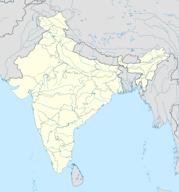
world.wikisort.org - India
Gorakhpur è una suddivisione dell'India, classificata come municipal corporation, di 624 570 abitanti, capoluogo del distretto di Gorakhpur e della divisione di Gorakhpur, nello stato federato dell'Uttar Pradesh. In base al numero di abitanti la città rientra nella classe I (da 100 000 persone in su).[4]
| Gorakhpur Corporazione Municipale (Municipal Corporation) | |
|---|---|
 | |
| Localizzazione | |
| Stato | |
| Stato federato | |
| Divisione | Gorakhpur |
| Distretto | Gorakhpur |
| Territorio | |
| Coordinate | 26°45′40″N 83°22′00″E |
| Altitudine | 69[1] m s.l.m. |
| Superficie | 141 km² |
| Abitanti | 624 570 (2001) |
| Densità | 4 429,57 ab./km² |
| Altre informazioni | |
| Lingue | hindi, inglese |
| Cod. postale | 273001[2] |
| Prefisso | 551[3] |
| Fuso orario | UTC+5:30 |
| Cartografia | |
Geografia fisica
La città è situata a 26° 45' 18 N e 83° 22' 26 E e ha un'altitudine di 69 m s.l.m.[1]
Società
Evoluzione demografica
Al censimento del 2001 la popolazione di Gorakhpur assommava a 624 570 persone, delle quali 330 450 maschi e 294 120 femmine. I bambini di età inferiore o uguale ai sei anni assommavano a 78 880, dei quali 41 122 maschi e 37 758 femmine. Infine, coloro che erano in grado di saper almeno leggere e scrivere erano 435 263, dei quali 251 133 maschi e 184 130 femmine.[5]
Note
- (EN) Falling Rain Genomics, Inc, Gorakhpur, India Page, su fallingrain.com. URL consultato l'11 luglio 2008.
- (EN) India Post, Pincode search - Gorakhpur, su indiapost.gov.in. URL consultato il 28 luglio 2008.
- (EN) Bharat Sanchar Nigam Ltd, STD Codes for cities in Uttar Pradesh, su bsnl.co.in. URL consultato il 28 luglio 2008 (archiviato dall'url originale il 18 gennaio 2008).
- (EN) Census of India, Alphabetical list of towns and their population - Uttar Pradesh (PDF), su censusindia.gov.in. URL consultato il 21 maggio 2008.
- (EN) Census of India 2001, Population, population in the age group 0-6 and literates by sex - Cities/Towns (in alphabetic order): 2001, su censusindia.net. URL consultato il 20 giugno 2008 (archiviato dall'url originale il 16 giugno 2004).
Altri progetti
 Wikimedia Commons contiene immagini o altri file su Gorakhpur
Collegamenti esterni
- (EN) Gorakhpur, su Enciclopedia Britannica, Encyclopædia Britannica, Inc.
| Controllo di autorità | VIAF (EN) 152446225 · LCCN (EN) n80135928 · J9U (EN, HE) 987007559764605171 · WorldCat Identities (EN) lccn-n80135928 |
|---|
На других языках
[de] Gorakhpur
Gorakhpur (Hindi: गोरखपुर, Urdu: .mw-parser-output .Arab a,.mw-parser-output a bdi.Arab{text-decoration:none!important}.mw-parser-output .Arab{font-size:120%}گورکھپور; Gorakhpur, [.mw-parser-output .IPA a{text-decoration:none}ˈgoːrʌkʰpʊr]) ist eine etwa 670.000 Einwohner zählende Distriktshauptstadt im nordindischen Bundesstaat Uttar Pradesh.[en] Gorakhpur
Gorakhpur is a city in the Indian state of Uttar Pradesh, along the banks of the Rapti river in the Purvanchal region. It is situated 272 kilometers east of the state capital Lucknow. It is the administrative headquarters of Gorakhpur district, North Eastern Railway Zone and Gorakhpur division. The city is home to the Gorakhnath Math, a Gorakhnath temple. The city also has an Indian Air Force station, since 1963. Gita Press, the world's largest publisher of Hindu religious texts like Ramayana and Mahabharat is also located in Gorakhpur which was established here in 1926.[lower-alpha 1][14][15]- [it] Gorakhpur
[ru] Горакхпур
Горакхпур (хинди गोरखपुर, англ. Gorakhpur) — город в индийском штате Уттар-Прадеш. Административный центр округа Горакхпур[1]. Горакхпур расположен на берегах реки Рапти на востоке штата Уттар-Прадеш, близ границы с Непалом.Другой контент может иметь иную лицензию. Перед использованием материалов сайта WikiSort.org внимательно изучите правила лицензирования конкретных элементов наполнения сайта.
WikiSort.org - проект по пересортировке и дополнению контента Википедии
