world.wikisort.org - India
Teghra is a village in Bihiya block of Bhojpur district in Bihar, India. As of 2011, its population was 3,049, in 420 households. It is located northeast of Bihiya, at a crossroads, with one road running north–south from Jhaua to Jagdishpur and the other running east–west from Arrah to Shahpur.[2]
Teghra | |
|---|---|
Village | |
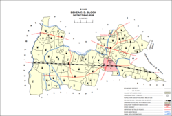 Map of Teghra (#149) in Behea block | |
 Teghra Location in Bihar, India  Teghra Teghra (India) | |
| Coordinates: 25.5908°N 84.46436°E[1] | |
| Country | India |
| State | Bihar |
| District | Bhojpur |
| Area | |
| • Total | 0.130 km2 (0.050 sq mi) |
| Elevation | 60 m (200 ft) |
| Population (2011) | |
| • Total | 3,049[2] |
| Languages | |
| • Official | Bhojpuri, Hindi |
| Time zone | UTC+5:30 (IST) |
References
- "Geonames.org. Teghra". Retrieved 18 August 2020.
- "Census of India 2011: Bihar District Census Handbook - Bhojpur, Part A (Village and Town Directory)". Census 2011 India. pp. 436–475. Retrieved 18 August 2020.
This article related to a location in Bihar is a stub. You can help Wikipedia by expanding it. |
Текст в блоке "Читать" взят с сайта "Википедия" и доступен по лицензии Creative Commons Attribution-ShareAlike; в отдельных случаях могут действовать дополнительные условия.
Другой контент может иметь иную лицензию. Перед использованием материалов сайта WikiSort.org внимательно изучите правила лицензирования конкретных элементов наполнения сайта.
Другой контент может иметь иную лицензию. Перед использованием материалов сайта WikiSort.org внимательно изучите правила лицензирования конкретных элементов наполнения сайта.
2019-2026
WikiSort.org - проект по пересортировке и дополнению контента Википедии
WikiSort.org - проект по пересортировке и дополнению контента Википедии