world.wikisort.org - India
Sikandarpur is a village in Sikandarpur Sarausi block of Unnao district, Uttar Pradesh, India.[2] Located 10km northwest of the city of Unnao,[1] near the Barhota lake,[3] it serves as the block headquarters as well as the seat of a nyaya panchayat.[1] It is also the namesake of a historical pargana.[1] The main crops in Sikandarpur are wheat, barley, gram, juwar, and paddy, and irrigation is largely done by wells.[1] It has a post office and a veterinary hospital.[1] As of 2011, its population is 4,510, in 752 households.[2]
Sikandarpur | |
|---|---|
Village | |
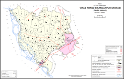 Map showing Sikandarpur (#142) in Sikandarpur Sarausi CD block | |
 Sikandarpur Location in Uttar Pradesh, India | |
| Coordinates: 26°34′N 80°23′E[1] | |
| Country India | |
| State | Uttar Pradesh |
| District | Unnao |
| Area | |
| • Total | 5.579 km2 (2.154 sq mi) |
| Population (2011)[2] | |
| • Total | 4,510 |
| • Density | 810/km2 (2,100/sq mi) |
| Languages | |
| • Official | Hindi |
| Time zone | UTC+5:30 (IST) |
| Vehicle registration | UP-35 |
History
Sikandarpur was originally called Burhanpur, but the name was changed in 1297 by Sikandar Khan, an agent of Ala-ud-Din Khilji. It later lent its name to a pargana, previously named after the neighbouring village of Sarosi; C.A. Elliott wrote in 1862 that the name change had "recently become habitual" at the time.[3]
At the turn of the 20th century, Sikandarpur was described as one of the main villages in its namesake pargana.[3] It had a lower primary school and a temple to Mahadeo, and its population as of 1901 was 1,727, including a Muslim minority of 263.[3] Brahmins were the most numerous caste at the time.[3]
References
- Baghel, Amar Singh (1979). Uttar Pradesh District Gazetteers: Unnao. Rampur: Government Press. pp. 272–3. Retrieved 5 July 2021.
- "Census of India 2011: Uttar Pradesh District Census Handbook - Unnao, Part A (Village and Town Directory)". Census 2011 India. pp. 262–79. Retrieved 5 July 2021.
- Nevill, H.R. (1903). Unao: A Gazetteer, Being Volume XXXVIII Of The District Gazetteers Of The United Provinces Of Agra And Oudh. Allahabad: Government Press. p. 239-43. Retrieved 5 July 2021.
Другой контент может иметь иную лицензию. Перед использованием материалов сайта WikiSort.org внимательно изучите правила лицензирования конкретных элементов наполнения сайта.
WikiSort.org - проект по пересортировке и дополнению контента Википедии