world.wikisort.org - India
Rajnagar is the nearest village to Madhubani, Bihar, India. The ruins of the Rajnagar Palace, destroyed in the 1934 Nepal–Bihar earthquake, are located here.
This article needs additional citations for verification. (June 2021) |
Rajnagar | |
|---|---|
Village | |
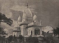
 Shiva Temple at Rajnagar before the earthquake, 1934 | |
 Rajnagar Location in Bihar, India  Rajnagar Rajnagar (India) | |
| Coordinates: 26.3958°N 86.1608°E | |
| Country | India |
| State | Bihar |
| Region | Mithila |
| District | Madhubani |
| Government | |
| • Type | Madhubani Municipal Corporation |
| Languages | |
| • Official | Maithili, Hindi, Urdu |
| Time zone | UTC+5:30 (IST) |
| PIN | 847235 |
| ISO 3166 code | IN-BR |
| Website | madhubani |
History
Maharajadhiraj Sir Rameshwar Singh wanted to shift the headquarters of Raj Darbhanga from Darbhanga to Rajnagar and spent money in building palaces and temples and excavating or renovating tanks.[1] The palaces were ruined almost beyond repair and the temples were also very badly damaged.[1] The earthquake rendered the main palace through the Durga hall and the roof over the inner shrines into a mass of ruins and the marble image of the deity broke into pieces.[1]
The Shiva temple built on the South Indian model was beyond repair.[2]
The village has had electricity since 1959. A railway station of the North-Eastern Railway serves the village.[2] The village is also the centre of trade in Euryale ferox (water berries).[2]
Gallery
 Kali Temple at Raj Nagar
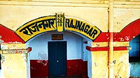 Rajnagar Railway Station is located in Madhubani district
 A Durga temple in the Navlakha palace campus


References
- Chaudhury, P. C. Roy (1964). Bihar District Gazetteers: Darbhanga. Superintendent Secretariat Press, Bihar. p. 738. Retrieved 4 June 2021.
- Chaudhury, P. C. Roy (1964). Bihar District Gazetteers: Darbhanga. Superintendent Secretariat Press, Bihar. p. 739. Retrieved 4 June 2021.
External links
Другой контент может иметь иную лицензию. Перед использованием материалов сайта WikiSort.org внимательно изучите правила лицензирования конкретных элементов наполнения сайта.
WikiSort.org - проект по пересортировке и дополнению контента Википедии