world.wikisort.org - India
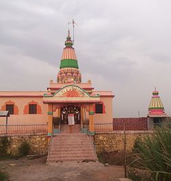
Padali is a census village in the Satara district, in the Indian state of Maharashtra. It is surrounded by a Mountains on its three sides. There is a big temple of Heljaidevi Mandir at Village. Agriculture is the main occupation in the village with more than 75% of the total area being used for agricultural activities.
This article does not cite any sources. (January 2018) |
Padali | |
|---|---|
Village | |
 Heljai Mandir Padali | |
 Padali Location in Maharashtra, India | |
| Coordinates: 17.4801163°N 74.1856956°E | |
| Country | |
| State | Maharashtra |
| District | Satara |
| Government | |
| • Body | Grampanchayat |
| • Sarpanch | Surekha Jadhav |
| Elevation | 56 m (184 ft) |
| Population (2011) | |
| • Total | 3,550 |
| Demonym(s) | Padalkar |
| Time zone | UTC+5:30 (IST) |
| PIN | 415106 |
| Telephone code | +91-2164 |
| Vehicle registration | MH- 50 |
| Website | www |
As per constitution of India and Panchyati Raaj Act, Padali village is administrated by Sarpanch (Head of Village) who is elected representative of village.

History
As per constitution of India and Panchyati Raaj Act, Padali village is administrated by Sarpanch (Head of Village) who is elected representative of village.
List of Sarpanch
- Surekha Jadhav 2017-2022
- Manjusha Bhoj 2012-2017
- Bhanudash Jadhav 2007-2012
- Uma Augade 2002-2007
- Shivaji Bhoj 1997-2002
Geography
Padali is a village in Karad Taluka in Satara District of Maharashtra, India. It belongs to Desh or Paschim Maharashtra region and to Pune Division. It is located 32 km towards South from district headquarters Satara, 28 km from Karad, 276 km from state capital Mumbai. Pin code is 415106 and post office is Padali (Satara). Gaikwadwadi(1.5 km), Gosavewadi(1.5 km), Banugadewadi(1.3 km), Wather( 5.3 km ), Sathewadi( 2.5 km ), are the nearby villages to Padali. Padali is surrounded by Karad Taluka towards North Kadegaon Taluka, Kadegaon Taluka towards South, Koregaon Taluka towards east, Patan Taluka towards west.
Satara, Wai, Mahabaleswar, Karad are the nearby cities.
Locality
Railway station
- Satara Rail Way Station - 35 km
- Targaon Rail Way Station - 10 km
Engineering Colleges Near Padali
- Satara Polytechnic Khindwadi Satara
- K.B.P. Polytechnic, Panmalevadi varied Satara
- Gourishankar Polytechnic, Limb Khind Satara
- Government Eng. College, Vidhyanagar Karad
- Satara College of Pharmacy Degaon, Satara
Schools & Colleges near Padali
- Z.P. Primary School Padali
- Sardar Babasaheb Mane Vidyalaya Padali
References
Другой контент может иметь иную лицензию. Перед использованием материалов сайта WikiSort.org внимательно изучите правила лицензирования конкретных элементов наполнения сайта.
WikiSort.org - проект по пересортировке и дополнению контента Википедии