world.wikisort.org - India
Kyelang (also spelled Keylong) is a town and the administrative centre of the Lahaul and Spiti district in the Indian state of Himachal Pradesh, 71 kilometres (44 mi) north of Manali via Atal Tunnel and 120 km (75 mi) from the Indo-Tibetan border. It is located along the Manali-Leh Highway, about 7 km (4+1⁄2 mi) northeast of intersection of the Chandra, Bhaga, and Chenab valleys, on the banks of Bhaga River.
Kyelang | |
|---|---|
Town | |
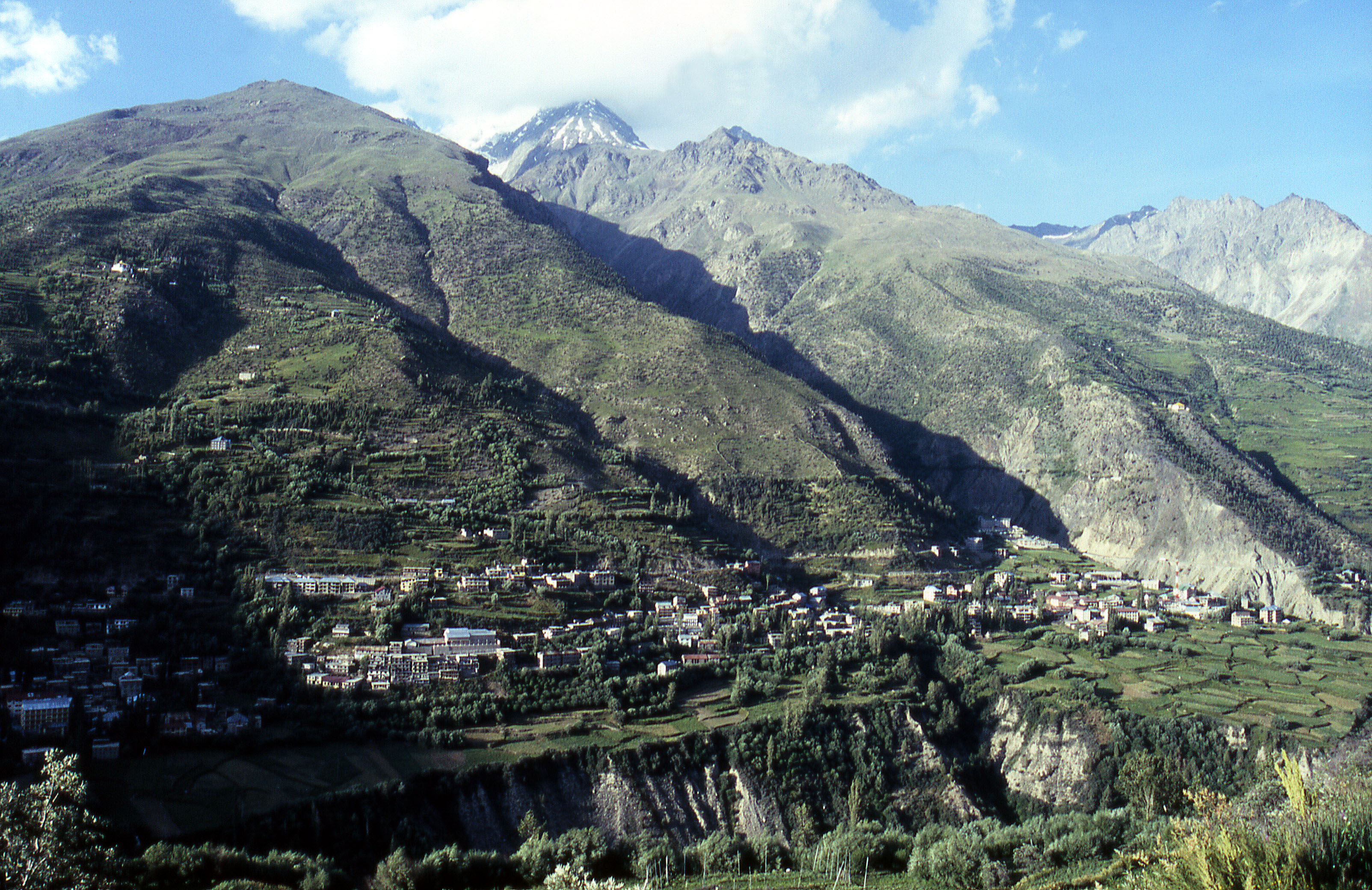
Kyelang, viewed from Kardang Monastery | |
 Kyelang  Kyelang | |
| Coordinates: 32.58°N 77.03°E | |
| Country | |
| State | |
| District | Lahaul and Spiti |
| Elevation | 3,080 m (10,100 ft) |
| Population | |
| • Total | 1,150 |
| Languages | |
| • Official | Hindi |
| Time zone | UTC+5:30 (IST) |
| Vehicle registration | HP-42 |

Sights and festivals
Kyelang faces the famous Kardang Monastery, the largest and most important monastery in Lahaul, of the Drukpa sect of Tibetan Buddhism, which is on a slope across the river from Keylong.
Sights near Kyelang include the Kardang, Shasur, and Tayul monasteries, all within a few kilometres of Kyelang. There is also a small temple dedicated to the local deity Kelang Wazir in the house of Shri Nawang Dorje that may be visited upon arrangement.
The annual Lahaul Festival is held here each July with a big, busy market and a number of cultural activities.[1]
Tourism
Kyelang is the district headquarters of Lahaul and Spiti district and is home to most of the government offices and facilities in Lahaul. It hosts a regular bazaar.
There are some tourist facilities including a Circuit House, a Public Works Department (PWD) Rest House, a Sainik (Army) Rest House, a Tourist Bungalow, and a number of small hotels.[2]
If you are traveling by car or bike, please adhere speed limits in Lahual spiti valley as speed cameras are in use throughout the area and you will be fined.
Access
Kyelang is accessible from Manali via the Manali-Leh Highway, a part of NH21. It is located about 71 km (44 mi) north of Manali at an altitude of 3,080 m (10,100 ft) and used to remain cut off from the outside world for six months from late October to mid-May due to heavy snowfall at Rohtang pass until the opening of Atal Tunnel in October 2020. Keylang is now accessible year round, but road blocks can occur in winter lasting several days. The peak travel season is during May-June and October, when a lot of tourists visit Rohtang pass and Atal tunnel. There are many buses in summer from Kulu and Manali.
The Manali to Atal tunnel south portal is 25.6km via Solang valley road. The length of Atal tunnel up to North portal is 9 km. From the North portal one has to cross bridge on Chandra river and then turn left to go to Sissu 7 km (4.3 mi) away, then continue to Tandi 22 km (14 mi) away, and then turn right to reach Keylong.
Atal tunnel
Due to the military significance of the Leh-Manali highway and the need to keep it open for the entire year, the Indian government began building the $320 million 9 km (5.6 mi) long horseshoe shaped Atal Tunnel project in 2010 to bypass Rohtang pass to create a much safer and faster year-round link to Kyelang.[3] The tunnel is now open for traffic and it has shortened the distance between Manali and Keylang by 45 km (28 mi), and the travel time from Manali to Keylang is about 2 hrs now. While it used to take 4 to 6 hours to ascend, negotiate, and descend the Rohtang pass, it will take only about 15 minutes to travel through the Atal tunnel.
Another way to access the area is by via air to Kullu and then travelling on the Leh-Manali highway to Kyelang.
Climate
| Climate data for Kyelang (1961–1990, rainfall 1951–2000) | |||||||||||||
|---|---|---|---|---|---|---|---|---|---|---|---|---|---|
| Month | Jan | Feb | Mar | Apr | May | Jun | Jul | Aug | Sep | Oct | Nov | Dec | Year |
| Record high °C (°F) | 13.1 (55.6) |
9.0 (48.2) |
16.7 (62.1) |
18.7 (65.7) |
25.9 (78.6) |
27.7 (81.9) |
28.7 (83.7) |
28.2 (82.8) |
27.1 (80.8) |
22.9 (73.2) |
20.2 (68.4) |
13.9 (57.0) |
28.7 (83.7) |
| Average high °C (°F) | 6.7 (44.1) |
6.0 (42.8) |
9.8 (49.6) |
14.8 (58.6) |
22.1 (71.8) |
25.9 (78.6) |
26.8 (80.2) |
26.7 (80.1) |
25.6 (78.1) |
21.8 (71.2) |
16.3 (61.3) |
12.1 (53.8) |
17.9 (64.2) |
| Average low °C (°F) | −16.5 (2.3) |
−17.7 (0.1) |
−13.8 (7.2) |
−7.4 (18.7) |
−0.9 (30.4) |
2.9 (37.2) |
5.3 (41.5) |
6.7 (44.1) |
1.3 (34.3) |
−4.1 (24.6) |
−7.7 (18.1) |
−14.1 (6.6) |
−5.5 (22.1) |
| Record low °C (°F) | −19.4 (−2.9) |
−19.7 (−3.5) |
−16.1 (3.0) |
−13.6 (7.5) |
−1.9 (28.6) |
−0.2 (31.6) |
1.7 (35.1) |
4.6 (40.3) |
−0.1 (31.8) |
−8.9 (16.0) |
−10.4 (13.3) |
−17.5 (0.5) |
−19.7 (−3.5) |
| Average rainfall mm (inches) | 78.0 (3.07) |
92.8 (3.65) |
141.1 (5.56) |
88.2 (3.47) |
71.1 (2.80) |
25.8 (1.02) |
60.3 (2.37) |
42.1 (1.66) |
55.5 (2.19) |
24.4 (0.96) |
25.8 (1.02) |
35.3 (1.39) |
740.4 (29.15) |
| Average rainy days (≥ 2.5 mm) | 6.3 | 5.9 | 8.7 | 6.5 | 5.4 | 2.2 | 5.6 | 4.3 | 3.5 | 2.0 | 1.6 | 3.1 | 55.1 |
| Average relative humidity (%) (at 08:30 IST) | 74 | 76 | 75 | 66 | 62 | 62 | 74 | 77 | 64 | 52 | 54 | 67 | 67 |
| Source: India Meteorological Department[4] | |||||||||||||
References
- "Lahaul & Spiti travel".
- http://hplahaulspiti.nic.in/TouristPlaces.htm [dead link]
- Polgreen, Lydia "India Digs Under Top of the World to Match Rival". New York Times. Accessed 31 July 2010.
- "Climate of Himachal Pradesh" (PDF). Climatological Summaries of States Series - No. 15. India Meteorological Department. January 2010. pp. 65–68. Archived from the original (PDF) on 20 February 2020. Retrieved 8 March 2020.
External links
На других языках
[de] Keylong
Keylong (auch Kyelang, Hindi केलांग, Kelaṅg) ist ein mittelgroßes Dorf (Village) im indischen Bundesstaat Himachal Pradesh.- [en] Kyelang
Другой контент может иметь иную лицензию. Перед использованием материалов сайта WikiSort.org внимательно изучите правила лицензирования конкретных элементов наполнения сайта.
WikiSort.org - проект по пересортировке и дополнению контента Википедии