world.wikisort.org - India
Kapsi is a village in the Kanker district of the Indian state of Chhattisgarh. It is situated on Chhattisgarh State Highway 25 roughly 110 km (68 mi) south-west of the district headquarters Kanker and 10 km (6.2 mi) north-east of the tehsil headquarters Pakhanjur. The village holds significance as a model village under both the Sansad Adarsh Gram Yojana and the National Rurban Mission of the Government of India. Owing to its sizeable tribal population, it is defined as a Scheduled Area under the Fifth Schedule of the Constitution of India.[1]
Kapsi
कापसी | |
|---|---|
Village | |
 Netaji Chowk, Chhote Kapsi | |
 Interactive map of Kapsi | |
 Kapsi Location in Chhattisgarh, India  Kapsi Kapsi (India) | |
| Coordinates: 20.0907444°N 80.6770786°E | |
| Country | |
| State | Chhattisgarh |
| District | Kanker |
| Area | |
| • Total | 40.4026 km2 (15.5995 sq mi) |
| Population (2011) | |
| • Total | 4,179 |
| • Density | 100/km2 (270/sq mi) |
| Languages | |
| • Official | Hindi, Chhattisgarhi |
| Time zone | UTC+5:30 (IST) |
| PIN | 494 771 |
| Telephone code | 91 7844 |
| Vehicle registration | CG 19 |
Geography
Kapsi is situated in the western part of the Kanker district bordering the state of Maharashtra. Geographically, it lies in the northern lowlands of the Bastar plateau and is the gateway to the historic Paralkot region.[2][3] The elevation of the village ranges from 310 to 330 m above sea level.

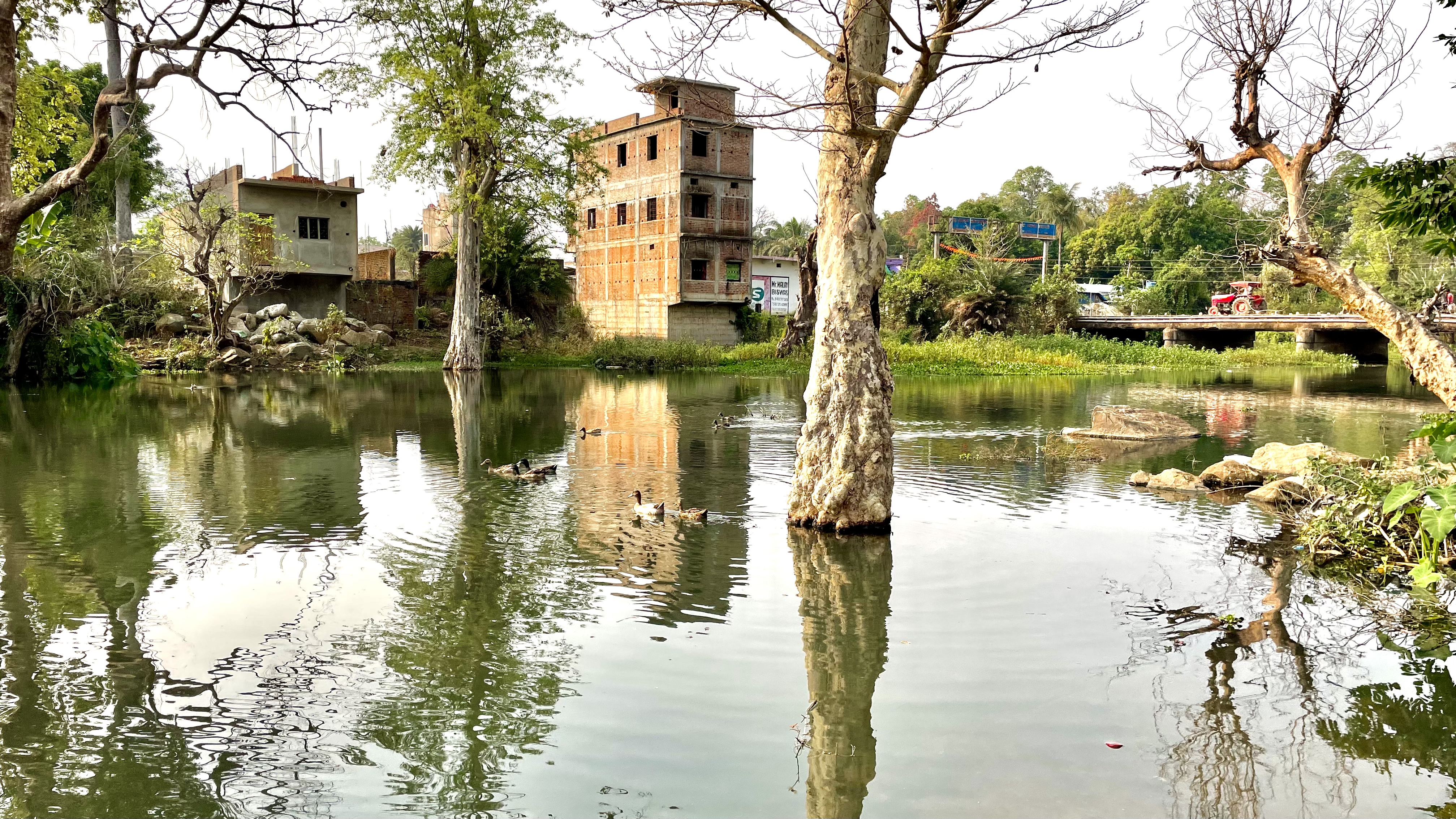
A local water body known as the Devda ravine meanders through the village and bifurcates it into the Bade Kapsi and Chhote Kapsi gram panchayats.[4][5] The region primarily features fertile lateritic soil, which is well-suited to agriculture due to its fine texture and darker hues.[3]
With its dense green cover, undulating terrain, hillocks, and stream courses, the region harbours habitats for diverse flora and fauna. The Kapsi Forest Range headquarters under the West Bhanupratappur Division is responsible for the safeguard of forests and conservation of biodiversity in the area.[6][7]

Civic administration
For planning and development under the Panchayati Raj system of local self-governance, Kapsi comprises two distinct gram panchayats (village councils) namely, Chhote Kapsi (Devanagari: छोटे कापसी) and Bade Kapsi (Devanagari: बड़े कापसी). At the block level, it is placed under the administrative jurisdiction of the Koyalibeda Janapad Panchayat.

Rurban Cluster
The two constituent gram panchayats of Kapsi i.e., Chhote Kapsi and Bade Kapsi, along with the neighbouring smaller gram panchayats of Aalor, Bapu Nagar and Harangarh form the Bade Kapsi Rurban Cluster. The aim of the project is to enhance the standard of living of the residents by providing better basic and social amenities.[8] The integrated cluster action plan (ICAP) was approved in 2018 under the phase II of Shyama Prasad Mukherjee Rurban Mission by the Govt. of India.[9] The vision of the cluster is to retain the dominant agrarian culture besides borrowing urban features such as developing skilled labour force and specializing into value addition based livelihood intensive activities such as maize processing.[10]
Sansad Adarsh Gram
Chhote Kapsi is the first village in the Kanker parliamentary constituency to be identified for development under the ambitious Sansad Adarsh Gram Yojana of the Government of India.[11] The inaugural ceremony was flagged off at a public event on 27 March 2015, by then Lok Sabha Member of Parliament (MP) Shri Vikram Usendi, in presence of government officials and public representatives from the district.[12] The primary objective of Sansad Adarsh Gram Yojana among other things, is to develop model villages to provide better standards of living and quality of life for inclusive growth of the rural population through:
- Improved basic amenities
- Higher productivity
- Enhanced human development
- Better livelihood opportunities
- Reduced disparities
- Access to rights and entitlements
- Wider social mobilization
- Enriched social capital.[13]
Demography
According to 2011 Census of India, the Kapsi rural agglomeration had a population of 4,179.
- Chhote Kapsi had a population of 3050. The village had a sex ratio of 992 females per 1,000 males and 11.54% of the population were under six years of age. Effective literacy rate was 83.91% i.e., higher than Chhattisgarh state average of 70.28%. Male literacy was 88.54% and female literacy was 79.27%.
- Bade Kapsi had a population of 1129. The village had a sex ratio of 1034 females per 1,000 males and 14.70% of the population were under six years of age. Effective literacy rate was 58.05% i.e., lower than Chhattisgarh state average of 70.28%. Male literacy was 64.63% and female literacy was 51.64%.
Economy
The economy of Kapsi is chiefly agrarian. Large scale cultivation of paddy and maize are undertaken throughout Rabi and Kharif crop seasons. Fish farming and dairy farming are other major primary sector activities practised by the populace. Under the aegis of Department of Fisheries, Govt. Of Chhattisgarh, the Bade Kapsi Rurban Cluster has become an important centre for pisciculture in the state, even exporting to the neighbouring states of Maharashtra and Odisha.[8] Sericulture and horticulture are also gradually gaining ground, albeit practised by a few.
Other forms of livelihood include peasantry, trade, small scale businesses, and local government jobs. The Netaji Market along with the adjacent smaller Atal Market in Chhote Kapsi is the center of all commercial activities for the village. A new market in Bade Kapsi, also known as the Gandhi Market, is quickly taking shape to cater to the growing demand of commercial spaces.
Banking services are provided by the following public-sector banks:
| Bank | Branch |
|---|---|
| State Bank of India (भारतीय स्टेट बैंक) | Kapsi |
| Chhattisgarh State Rural Bank (छत्तीसगढ़ राज्य ग्रामीण बैंक) | Kapsi |
| District Central Co-operative Bank Ltd. (जिला सहकारी केन्द्रीय बैंक मर्यादित) | Bade Kapsi |
Education
For primary and secondary education, Kapsi has a number of Hindi as well as English medium schools, run by the government and private institutions. The quality of education in these schools is generally good with a fair emphasis on extracurricular activities, though the infrastructure is just about satisfactory given the rural setting. The colleges in the district impart basic post-secondary higher education. For good quality and specialized higher education, people are entirely dependent on larger cities such as Bhilai, Durg and Raipur.
Healthcare
Healthcare facilities are minimal and a significant portion of the population still rely on home-made remedies and quackery as the first response to medical needs. A government run Primary Health Centre (PHC) and a handful of privately run health facilities provide primary healthcare. Higher healthcare needs are referred to cities such as Dhamtari, Bhilai and Raipur.
Utilities
Electricity
The electricity distribution and bill collection in Kapsi is the responsibility of Chhattisgarh State Power Distribution Company Limited (CSPDCL). The company operates a feeder substation and distribution center at Bade Kapsi.[14]
Telephone and internet
State owned Bharat Sanchar Nigam Limited (BSNL) provides wired landline, 2G/3G cellular telephony and fibre broadband internet services in Kapsi. Reliance Jio Infocomm Limited (Jio) has started providing 4G LTE cellular services from November 2021. A non-functional cellular tower erected by the now defunct Reliance Communications Limited (RCOM) of the Anil Dhirubhai Ambani Group also exists.
Both the BSNL and RCOM facilities were vandalized and set on fire by Maoist rebels in an attack in December 2008. The BSNL services were reinstated within a few weeks after the incident whereas the RCOM service remained suspended and was subsequently withdrawn.[15][16]
Transport
Road
Kapsi is situated on Chhattisgarh State Highway 25 and is served only by road transport. It is well connected to all nearby major towns and cities by buses operated at regular intervals. In addition, inexpensive shared transportation (Mahindra Bolero, Force Cruiser, Tata Ace, etc.) are available throughout the day for local commute.

The approximate distance of Kapsi from the regional major towns and cities by road is as follows:
| Town | Description | Distance |
|---|---|---|
| Pakhanjur | Tehsil headquarters, police station | 10 km (6.2 mi) |
| Bhanupratappur | Forest division headquarters | 60 km (37 mi) |
| Antagarh | Assembly constituency | 90 km (56 mi) |
| Kanker | District headquarters, parliamentary constituency | 110 km (68 mi) |
| Durg-Bhilai | Commercial/Educational centre | 180 km (110 mi) |
| Raipur | State capital | 250 km (160 mi) |
| Jagdalpur | Revenue division headquarters | 270 km (170 mi) |
Rail
Kapsi is not connected directly to the network of Indian Railways. The nearest local railway station is Keoti (KETI), at a distance of 50 km (31 mi) from Kapsi, on the Dalli Rajhara–Jagdalpur line. Daily DEMU services connect this station to Raipur via Durg. The nearest long-haul railway station is Durg Jn. (DURG), 180 km (110 mi) away on the Howrah–Nagpur–Mumbai line.
Air
The nearest domestic airport from Kapsi is Swami Vivekananda Airport in Naya Raipur, approximately 240 km (150 mi) away.
Tourism
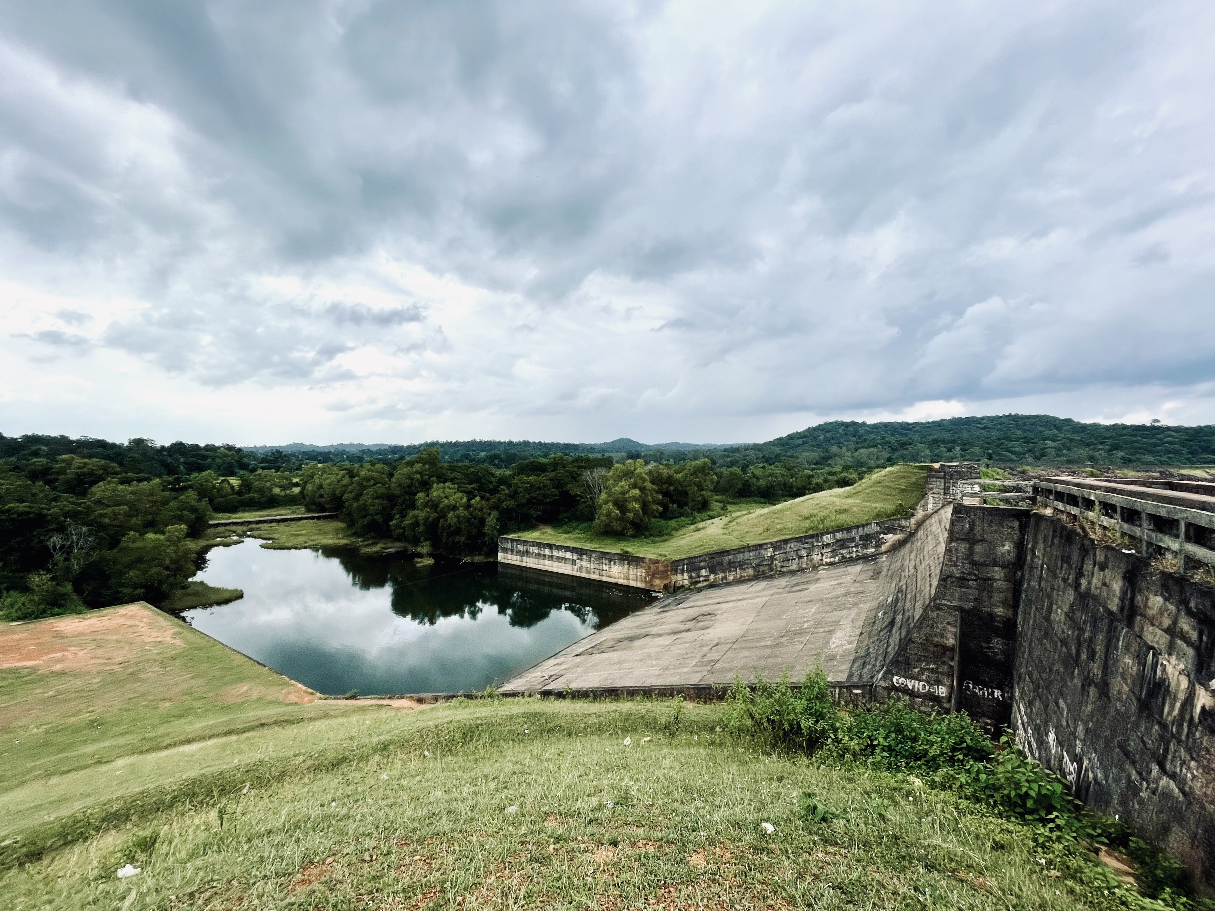
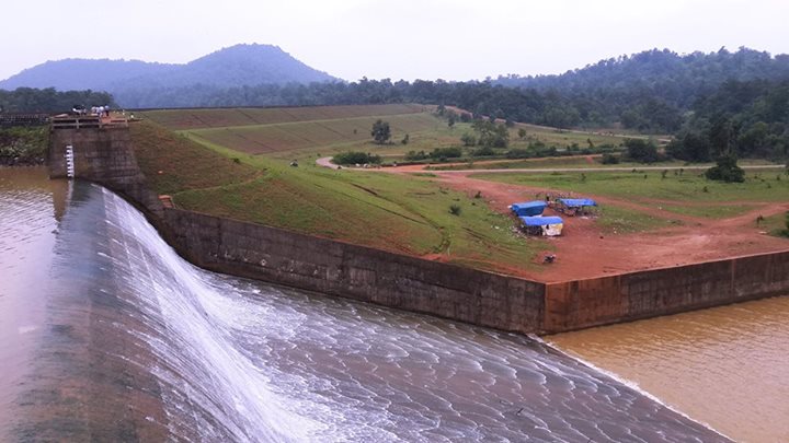
Kherkatta Dam, officially known as Paralkot Reservoir (Devanagari: परलकोट जलाशय) near Kapsi is the largest dam of the Kanker district. It is a popular local tourist spot and sees a large influx of visitors especially during the monsoon rains when water overflows from the 12 m (39 ft) high spillway.[17]

References
- "Scheduled Areas (States of Chhattisgarh, Jharkhand and Madhya Pradesh) Order, 2003". Bareactslive.com. Retrieved 20 April 2022.
- "About Chhattisgarh". Cgclimatechange.com.
- http://14.139.60.153/bitstream/123456789/3847/1/BASTAR%20DEVELOPMENT%20PLAN-SN1027.pdf [bare URL PDF]
- "छोटेकापसी पुल के पास देवदा नदी में फैली जलकुंभी पानी हो रहा दूषित". Naidunia.com. 13 June 2022.
- "Map of Bade Kapsi : 6 Structure Plan" (PDF). Tcp.cg.gov.in. Retrieved 30 June 2022.
- "वनों में लगी आग से बचाव की दी जानकारी". Nai Dunia.
- "पखांजुर में लोगों ने सीखे औषधीय पौधों के संर्वधन संरक्षण के गुर". Editorjee. 19 March 2020.
- "Archived copy". Archived from the original on 23 September 2017. Retrieved 24 March 2022.
{{cite web}}: CS1 maint: archived copy as title (link) - "SPMRM | Ministry of Rural Development | GOI".
- http://bihan.gov.in/pdf/Meeting_23-05-2017_NRuM.pdf [bare URL PDF]
- "Sansad Adarsh Gram Yojana, Villages adopted by MP under SAGY". Mapsofindia.com. Retrieved 30 June 2022.
- "Hindi ePaper, EPaper Download, Online Epaper, Newspaper in Hindi, Today Newspaper". Epaper.patrika.com.
- https://saanjhi.gov.in/pdf/Guidelines_English.pdf [bare URL PDF]
- "लापरवाह और बेपरवाह पावर स्टेशन बड़े कापसी". 10 August 2022.
- "Maoists attack BSNL, R-Com facilities". 15 December 2008.
- "All quiet during Maoist bandh in Kanker | India News - Times of India". The Times of India.
- "लबालब भरा जलाशय देखने उमड़ रही भीड़". 12 August 2022.
Другой контент может иметь иную лицензию. Перед использованием материалов сайта WikiSort.org внимательно изучите правила лицензирования конкретных элементов наполнения сайта.
WikiSort.org - проект по пересортировке и дополнению контента Википедии