world.wikisort.org - India
Holenarasipura is a town and taluk in Hassan district of Karnataka. The town is situated on the banks of the Hemavati, one of the tributaries of the Kaveri.
This article possibly contains original research. (February 2018) |
Holenarasipura
Hole Narsipura | |
|---|---|
Town | |
 Old Railway Station | |
 Holenarasipura Location in Karnataka, India | |
| Coordinates: 12.783°N 76.243°E | |
| Country | |
| State | Karnataka |
| District | Hassan |
| Government | |
| • Type | Town Municipal Council |
| • MLA | H. D. Revanna |
| Area | |
| • Total | 7.38 km2 (2.85 sq mi) |
| Elevation | 849 m (2,785 ft) |
| Population (2011) | |
| • Total | 29,938 |
| • Density | 10,807.2/km2 (27,991/sq mi) |
| Languages | |
| • Official | Kannada |
| Time zone | UTC+5:30 (IST) |
| PIN | 573 211 |
| Telephone code | +91-8175 |
| ISO 3166 code | IN-KA |
| Vehicle registration | KA-13 |
| Website | karnataka |
Demographics
As of 2011[update] India census,[1] Holenarasipura had a population of 29,938. Males constitute 51% of the population and females 49%. It has an average literacy rate of 73%, higher than the national average of 59.5%; with male literacy of 78% and female literacy of 68%. 11% of the population is under 6 years of age.
Location
Holenarasipura is on a National highway between Mysore and Hassan and on another State highway between Madikeri and Bangalore. It is connected to the rest of Karnataka and India by broad gauge railway. It is 32 km from Hassan, 90 km from Mysore, 175 km from Bangalore and 201 km from Mangalore.
Gallery
 Positioning of Hassan district in Karnataka
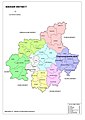 Hobli Map of Hassan district
 Map of Holenarasipura Taluk as per 2001 Census
 Map of Holenarasipura Taluk as per 2011 Census
 Holenarasipura Taluk - Hobli and Village Map
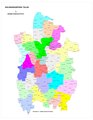 Holenarasipura Taluk - Grama Panchayat and Village Map
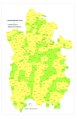 Holenarasipura Taluk Map about Fluoride content in DWS


Notable people
- Satchidanandendra Saraswati, philosopher, Advaita and Vedanta thinker.
- H. D. Deve Gowda, former Prime Minister.
- K. S. Ashwath, Kannada actor.
- Koundinya (Y. N. Nagesh), popular detective novelist in Kannada.
See also
- Saligrama, Mysore
- Ramanathapura
- Arkalgud
- Mangalore
- Keralapura
- Govindanahalli
- Kikkeri
- Panchalingeshwara Temple, Govindanahalli
References
- http://www.holenarasipurtown.mrc.gov.in/en/city-summary.
{{cite web}}: Missing or empty|title=(help)
External links
Другой контент может иметь иную лицензию. Перед использованием материалов сайта WikiSort.org внимательно изучите правила лицензирования конкретных элементов наполнения сайта.
WikiSort.org - проект по пересортировке и дополнению контента Википедии