world.wikisort.org - India
Edappatta is a village in Malappuram district in the state of Kerala, India.[1]
Edappatta | |
|---|---|
village | |
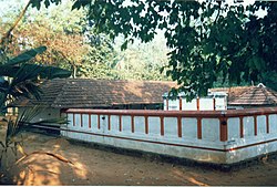
 Kattuputhoor Shiva Temple, Edappatta | |
 Edappatta Location in Kerala, India  Edappatta Edappatta (India) | |
| Coordinates: 11°4′0″N 76°17′0″E | |
| Country | |
| State | Kerala |
| District | Malappuram |
| Area | |
| • Total | 25.77 km2 (9.95 sq mi) |
| Population (2001) | |
| • Total | 20,321 |
| • Density | 656/km2 (1,700/sq mi) |
| Languages | |
| • Official | Malayalam, English |
| Time zone | UTC+5:30 (IST) |
| PIN | 679326 |
| Telephone code | 04933 |
| Vehicle registration | KL-10 |
| Nearest city | Melattur |
| Sex ratio | 1054 ♂/♀ |
| Literacy | 84% |
| Lok Sabha constituency | Malappuram |
| Vidhan Sabha constituency | Manjeri |
Location
Edappatta is located between Nilambur and Perinthalmanna in Malappuram District. Nearest Airport is Calicut Airport which is about 50km. Nearest Railway station is Melattur at about 3km.
Demographics
As of 2001[update] India census, Edappatta had a population of 20321 with 9787 males and 10534 females.[1]
Important Landmarks
- Darul Uloom Madhrassa
- Veliyanchery Highschool
- St.Mary's Church, Pathirikode
- Olipuzha River
Major Places
- MOONADI
- Veliyanchery
- Olappara
- Kizhakkumpadam
- Pullikkuth
- Pathirikode
- Edappatta Central
- Edappatta Puzhakkal Kund
- Eppikkadu
- Angilangadi
Transportation
Edappatta village connects to other parts of India through Perinthalmanna town. National highway No.66 passes through Tirur and the northern stretch connects to Goa and Mumbai. The southern stretch connects to Cochin and Trivandrum. Highway No.966 goes to Palakkad and Coimbatore. The nearest airport is at Kozhikode. The nearest major railway station is at Tirur.
External links
References
- "Census of India : Villages with population 5000 & above". Registrar General & Census Commissioner, India. Archived from the original on 8 December 2008. Retrieved 10 December 2008.
Текст в блоке "Читать" взят с сайта "Википедия" и доступен по лицензии Creative Commons Attribution-ShareAlike; в отдельных случаях могут действовать дополнительные условия.
Другой контент может иметь иную лицензию. Перед использованием материалов сайта WikiSort.org внимательно изучите правила лицензирования конкретных элементов наполнения сайта.
Другой контент может иметь иную лицензию. Перед использованием материалов сайта WikiSort.org внимательно изучите правила лицензирования конкретных элементов наполнения сайта.
2019-2025
WikiSort.org - проект по пересортировке и дополнению контента Википедии
WikiSort.org - проект по пересортировке и дополнению контента Википедии