world.wikisort.org - Germania
Rangsdorf è un comune di 11 369 abitanti del Brandeburgo, in Germania.
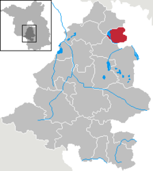
Appartiene al circondario (Landkreis) del Teltow-Fläming (targa TF).
| Rangsdorf comune | ||
|---|---|---|
| ||
 | ||
| Localizzazione | ||
| Stato | ||
| Land | ||
| Distretto | Non presente | |
| Circondario | Teltow-Fläming | |
| Territorio | ||
| Coordinate | 52°16′59″N 13°25′59″E | |
| Altitudine | 36 e 41 m s.l.m. | |
| Superficie | 33,79 km² | |
| Abitanti | 11 369[1] (31-12-2019) | |
| Densità | 336,46 ab./km² | |
| Altre informazioni | ||
| Cod. postale | 15834 | |
| Prefisso | 033708 | |
| Fuso orario | UTC+1 | |
| Codice Destatis | 12 0 72 340 | |
| Targa | TF | |
| Cartografia | ||
 Rangsdorf | ||
 | ||
| Sito istituzionale | ||

Storia
Nel 2003 al comune di Rangsdorf venne aggregato il comune di Machnow.[2]
Società
Evoluzione demografica
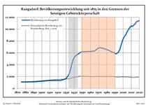 Sviluppo della popolazione dal 1875 entro gli attuali confini (Linea Blu: Popolazione; Linea puntata: Confronto dello sviluppo della popolazione dello stato del Brandenburgo; Sfondo grigio: Ai tempi del governo nazista; Sfondo rosso: Al tempo del governo comunista)
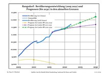 Sviluppo recente della popolazione (Linea blu) e previsioni


|
|
|
|
|
Fonti dei dati sono nel dettaglio nelle Wikimedia Commons.[4].
Suddivisione amministrativa
Il territorio comunale si divide in 3 zone, corrispondenti al centro abitato di Rangsdorf e a 2 frazioni (Ortsteil):
- Rangsdorf (centro abitato)
- Groß Machnow
- Klein Kienitz
Note
- Bevölkerung im Land Brandenburg nach amtsfreien Gemeinden, Ämtern und Gemeinden 31. Dezember 2019 (XLS-Datei; 83 KB) (Einwohnerzahlen auf Grundlage des Zensus 2019)
- (DE) Viertes Gesetz zur landesweiten Gemeindegebietsreform betreffend die Landkreise Havelland, Potsdam-Mittelmark, Teltow-Fläming, § 17, su bravors.brandenburg.de.
- Fonti dei dati sono nel dettaglio nelle Wikimedia Commons. Population Projection Brandenburg at Wikimedia Commons
- Population Projection Brandenburg at Wikimedia Commons, su commons.wikimedia.org.
Altri progetti
 Wikimedia Commons contiene immagini o altri file su Rangsdorf
Collegamenti esterni
- (DE) Sito ufficiale, su gemeinde-rangsdorf.de.
| Controllo di autorità | VIAF (EN) 160451962 · LCCN (EN) n2005082818 · GND (DE) 4193257-2 · WorldCat Identities (EN) lccn-n2005082818 |
|---|
На других языках
[de] Rangsdorf
Rangsdorf ist eine amtsfreie Gemeinde im Landkreis Teltow-Fläming in Brandenburg.[en] Rangsdorf
Rangsdorf is a municipality in the district of Teltow-Fläming in Brandenburg in Germany. It has an airfield [up to 1940 a genuine commercial airport] from where on 20 July 1944 Claus Schenk Graf von Stauffenberg took off on his fateful attempt to assassinate German leader Adolf Hitler at his military headquarters in East Prussia, the Wolfsschanze.[fr] Rangsdorf
Rangsdorf est une commune allemande de l'arrondissement de Teltow-Fläming, Land de Brandebourg.- [it] Rangsdorf
[ru] Рангсдорф
Рангсдорф (нем. Rangsdorf) — коммуна в Германии, в земле Бранденбург.Текст в блоке "Читать" взят с сайта "Википедия" и доступен по лицензии Creative Commons Attribution-ShareAlike; в отдельных случаях могут действовать дополнительные условия.
Другой контент может иметь иную лицензию. Перед использованием материалов сайта WikiSort.org внимательно изучите правила лицензирования конкретных элементов наполнения сайта.
Другой контент может иметь иную лицензию. Перед использованием материалов сайта WikiSort.org внимательно изучите правила лицензирования конкретных элементов наполнения сайта.
2019-2026
WikiSort.org - проект по пересортировке и дополнению контента Википедии
WikiSort.org - проект по пересортировке и дополнению контента Википедии