world.wikisort.org - Germania
Karstädt è un comune del Brandeburgo, in Germania. Appartiene al circondario del Prignitz.
| Karstädt comune | ||
|---|---|---|
| ||
 | ||
| Localizzazione | ||
| Stato | ||
| Land | ||
| Distretto | Non presente | |
| Circondario | Prignitz | |
| Territorio | ||
| Coordinate | 53°09′N 11°45′E | |
| Altitudine | 34 m s.l.m. | |
| Superficie | 253,55 km² | |
| Abitanti | 5 943 (2018) | |
| Densità | 23,44 ab./km² | |
| Altre informazioni | ||
| Cod. postale | 19357 | |
| Prefisso | (+49) 038797 | |
| Fuso orario | UTC+1 | |
| Codice Destatis | 12 0 70 173 | |
| Targa | PR | |
| Cartografia | ||
 Karstädt | ||
 | ||
| Sito istituzionale | ||

Storia
Il 31 dicembre 2001 vennero aggregati al comune di Karstädt i comuni di Blüthen, Dallmin, Groß Warnow, Kribbe, Laaslich, Premslin e Reckenzin.[1]
Nel 2003 vennero aggregati al comune di Karstädt i comuni di Boberow e Nebelin[2].
Società
Evoluzione demografica
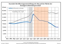 Sviluppo della popolazione dal 1875 entro gli attuali confini (Linea Blu: Popolazione; Linea puntata: Confronto dello sviluppo della popolazione dello Stato del Brandenburgo; Sfondo grigio: Ai tempi del governo nazista; Sfondo rosso: Al tempo del governo comunista)
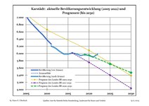 Sviluppo recente della popolazione (Linea blu) e previsioni


|
|
|
Fonti dei dati sono nel dettaglio nelle Wikimedia Commons.[4].
Suddivisione amministrativa
Il territorio comunale si divide in 13 zone (Ortsteil), corrispondenti al centro abitato di Karstädt e a 12 frazioni:
- Karstädt (centro abitato), con le località:
- Postlin
- Stavenow
- Blüthen, con le località:
- Klockow
- Strehlen
- Waterloo
- Boberow
- Dallmin
- Garlin, con le località:
- Bootz
- Dargardt
- Sargleben
- Seetz
- Groß Warnow, con la località:
- Klein Warnow
- Kribbe, con le località:
- Karwe
- Neuhof
- Wittmoor
- Laaslich, con la località:
- Lenzersilge
- Mankmuß, con le località:
- Birkholz
- Mesekow
- Nebelin
- Premslin, con le località:
- Glövzin
- Kaltenhof
- Neu Premslin
- Pröttlin, con le località:
- Pinnow
- Zapel
- Reckenzin, con la località:
- Streesow
Geografia fisica
Nella località di Streesow, ex comune indipendente, ora frazione di Karstädt, il fiume Tarnitz confluisce nella Löcknitz.
Note
- (DE) Bildung einer neuen Gemeinde Karstädt (PDF), in Amtsblatt für Brandenburg, anno 12, n. 52, Potsdam, 27 dicembre 2001, p. 904.
- (DE) Fünftes Gesetz zur landesweiten Gemeindegebietsreform betreffend die Landkreise Barnim, Märkisch-Oderland, Oberhavel, Ostprignitz-Ruppin, Prignitz, Uckermark, Kapitel 1, Abschnitt 5, § 25, comma 1
- Fonti dei dati sono nel dettaglio nelle Wikimedia Commons. Population Projection Brandenburg at Wikimedia Commons
- Population Projection Brandenburg at Wikimedia Commons, su commons.wikimedia.org.
Altri progetti
 Wikimedia Commons contiene immagini o altri file su Karstädt
Collegamenti esterni
- (DE) Sito ufficiale, su gemeinde-karstaedt.de.
| Controllo di autorità | VIAF (EN) 147624533 · GND (DE) 4355494-5 |
|---|
На других языках
[de] Karstädt (Prignitz)
Karstädt ist eine amtsfreie Gemeinde des Landkreises Prignitz in Brandenburg. Das Gemeindegebiet ist identisch mit dem von 1992 bis 2003 existierenden Amt Karstädt.[en] Karstädt
Karstädt is a municipality in the Prignitz district, in Brandenburg, Germany.[es] Karstädt (Brandeburgo)
Karstädt es un municipio situado en el distrito de Prignitz, en el estado federado de Brandeburgo (Alemania), a una altitud de 30 metros. Su población a finales de 2016 era de unos Karstädt habs. y su densidad poblacional, 20 hab/km².[2][3][fr] Karstädt (Prignitz)
Karstädt est une commune allemande de l'arrondissement de Prignitz, Land de Brandebourg.- [it] Karstädt (Brandeburgo)
[ru] Карштедт (Пригниц)
Карштедт (нем. Karstädt) — коммуна в Германии, в земле Бранденбург.Текст в блоке "Читать" взят с сайта "Википедия" и доступен по лицензии Creative Commons Attribution-ShareAlike; в отдельных случаях могут действовать дополнительные условия.
Другой контент может иметь иную лицензию. Перед использованием материалов сайта WikiSort.org внимательно изучите правила лицензирования конкретных элементов наполнения сайта.
Другой контент может иметь иную лицензию. Перед использованием материалов сайта WikiSort.org внимательно изучите правила лицензирования конкретных элементов наполнения сайта.
2019-2026
WikiSort.org - проект по пересортировке и дополнению контента Википедии
WikiSort.org - проект по пересортировке и дополнению контента Википедии