world.wikisort.org - Allemagne
Varel est une ville de la Frise, en Basse-Saxe, Allemagne.
| Varel | |
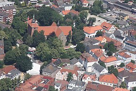
 Vue aérienne de Varel. | |
 Armoiries |
 Drapeau |
| Administration | |
|---|---|
| Pays | |
| Land | |
| Arrondissement (Landkreis) |
Arrondissement de Frise |
| Nombre de quartiers (Ortsteile) |
32 |
| Bourgmestre (Bürgermeister) |
Gerd-Christian Wagner |
| Partis au pouvoir | SPD |
| Code postal | 26316 |
| Code communal (Gemeindeschlüssel) |
03 4 55 026 |
| Indicatif téléphonique | 04451 |
| Immatriculation | FRI |
| Démographie | |
| Population | 24 001 hab. () |
| Densité | 211 hab./km2 |
| Géographie | |
| Coordonnées | 53° 23′ 49″ nord, 8° 08′ 10″ est |
| Altitude | 6 m |
| Superficie | 11 353 ha = 113,53 km2 |
| Localisation | |
| Liens | |
| Site web | www.varel.de |
| modifier |
|
Histoire
| Appartenances historiques
|
Les premières traces de peuplement connues dates d'environ 3 000 à 2 000 ans avant J.-C..
Le site et la région sont christianisés par Willehad au VIIIe siècle.
La ville subit le Raz-de-marée de la Saint-Marcel en 1362.
Elle fut la résidence des seigneurs de Kniphausen sous le Saint-Empire.
De 1811 à 1813, elle appartint à l'Empire français, comme tout le pays d'Oldenbourg.
Elle reçoit le statut de ville libre en 1958.
En 1905, le docteur Robert Almers et l'ingénieur August Spokhorst y fondent l'entreprise automobile Hansa, qui devint en 1914 Hansa-Lloyd[1].
Géographie
Varel est située près de l'embouchure de la Jade, au sud de la baie de Jade, à environ quinze kilomètres au sud de Wilhelmshaven et à trente kilomètres au nord d'Oldenbourg.
Quartiers
|
|
|
|
Personnalités liées à la ville
- Arne Groh (1962-), sculpteur, né à Seghorn.
- August Spokhorst et Robert Almers, fondateurs de l'entreprise automobile Hansa en 1905.
Jumelages
 Barth (Allemagne)
 Jackson (Michigan) (États-Unis)
Notes et références
- Site internet www.automania.be __"Borgward & Hansa story".
- Portail de la Basse-Saxe
На других языках
[de] Varel
Varel [.mw-parser-output .IPA a{text-decoration:none}ˈfaːʀəl] ist eine Mittelstadt und selbständige Gemeinde im Landkreis Friesland, am Jadebusen in Niedersachsen und südlich von Wilhelmshaven. Sie ist mit 23.957 Einwohnern die größte Stadt im Landkreis Friesland.[en] Varel
Varel ([ˈfaːʁəl]) is a town in the district of Friesland, in Lower Saxony, Germany. It is situated near the Jade River and the Jade Bight, approximately 15 kilometres (9.3 mi) south of Wilhelmshaven and 30 kilometres (19 mi) north of Oldenburg. With a population of 23,984 (2020) it is the biggest town in the district of Friesland.- [fr] Varel
[ru] Фарель
Фа́рель (нем. Varel [ˈfaːʁəl], н.-нем. Varel) — город в Германии, в земле Нижняя Саксония.Другой контент может иметь иную лицензию. Перед использованием материалов сайта WikiSort.org внимательно изучите правила лицензирования конкретных элементов наполнения сайта.
WikiSort.org - проект по пересортировке и дополнению контента Википедии

