world.wikisort.org - Alemania
Woltersdorf es un municipio con 8.092 habitantes en Brandeburgo. Está en el oeste del Distrito de Oder-Spree y tiene una frontera directa con Berlín.
| Woltersdorf | ||
|---|---|---|
| Entidad subnacional | ||
 | ||
 Woltersdorf Localización de Woltersdorf en Alemania | ||
 Ubicación de Woltersdorf | ||
| Coordenadas | 52°27′02″N 13°45′17″E | |
| Idioma oficial | Alemán | |
| Entidad | Municipio de Alemania | |
| • País |
| |
| • Estado federado | Brandeburgo | |
| • Distrito | Oder-Spree | |
| Dirigentes | ||
| • Alcalde | Margitta Decker | |
| Superficie | ||
| • Total | 9,12 km² | |
| Altitud | ||
| • Media | 50 m s. n. m. | |
| Población (31 de diciembre de 2020) | ||
| • Total | 8,092 hab. | |
| • Densidad | 923,57 hab/km² | |
| Huso horario | CET (UTC +1) | |
| • en verano | CEST (UTC +2) | |
| Código postal | 15569[1] | |
| Prefijo telefónico | 03362 | |
| Matrícula | LOS | |
| Número oficial de comunidad | 12067544 | |
| Sitio web oficial | ||
El municipio tiene conexión con la autopista y con el tren via Erkner. La alcaldesa de Woltersdorf es Margitta Decker ("Unser Woltersdorf", Nuestro Woltersdorf).
Geografía
Localización y barrios
Se encuentra en lagos Flakensee, Kalksee y Bauersee entre Schöneiche, el bosque de Berlín y la ciudad Erkner.
Woltersdorf abarca los barrios Schönblick, Springeberg y Stolp.
Las comunidades vecinas
Woltersdorf linda con (en el sentido de las agujas del reloj, incipiente el norte) Rüdersdorf, Erkner, Berlín y Schöneiche.
Demografía
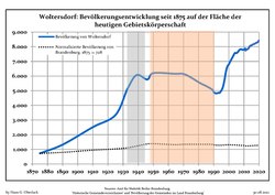 Tendencia poblacional desde 1875 (línea azul: población; línea punteada: comparación con tendencias poblacionales del estado de Brandenburg; fondo gris: tiempo de gobierno Nazi; fondo rojo: tiempo de Gobierno comunista)
 Proyecciones y desarrollo poblacional reciente (Desarrollo poblacional antes del censo del 2011 (línea azul); Desarrollo poblacional reciente de acuerdo al Censo en Alemania del 2011 (línea azul con bordes); Proyecciones oficiales para el período 2005-2030 (línea amarilla); para el período 2017-2030 (línea escarlata); para el período 2020-2030 (línea verde)


| Woltersdorf: Desarrollo poblacional [2] | ||||||||||||||||||||||||||||||||||||||||||||||||||||||||||||||||||||||||||
|---|---|---|---|---|---|---|---|---|---|---|---|---|---|---|---|---|---|---|---|---|---|---|---|---|---|---|---|---|---|---|---|---|---|---|---|---|---|---|---|---|---|---|---|---|---|---|---|---|---|---|---|---|---|---|---|---|---|---|---|---|---|---|---|---|---|---|---|---|---|---|---|---|---|---|
|
|
| ||||||||||||||||||||||||||||||||||||||||||||||||||||||||||||||||||||||||
Referencias
- Worldpostalcodes.org, código postal n.º 15569.
- Las fuentes de datos detalladas pueden ser encontradas en Wikimedia Commons.Population Projection Brandenburg at Wikimedia Commons
| Control de autoridades |
|---|
 Datos: Q628778
 Multimedia: Woltersdorf (bei Berlin) / Q628778
На других языках
[de] Woltersdorf (bei Berlin)
Woltersdorf ist eine amtsfreie Gemeinde im Landkreis Oder-Spree in Brandenburg. Sie ist die kleinste Kommune Deutschlands mit eigener Straßenbahn.[en] Woltersdorf, Brandenburg
Woltersdorf is a municipality in the Oder-Spree district in Brandenburg. It is often referred to as "near Berlin" (German: "bei Berlin") or "near Erkner" (German: "bei Erkner") as there are a number of other places bearing the same name in Germany.- [es] Woltersdorf
[ru] Вольтерсдорф (Бранденбург)
Вольтерсдорф (нем. Woltersdorf) — коммуна в Германии, в земле Бранденбург.Текст в блоке "Читать" взят с сайта "Википедия" и доступен по лицензии Creative Commons Attribution-ShareAlike; в отдельных случаях могут действовать дополнительные условия.
Другой контент может иметь иную лицензию. Перед использованием материалов сайта WikiSort.org внимательно изучите правила лицензирования конкретных элементов наполнения сайта.
Другой контент может иметь иную лицензию. Перед использованием материалов сайта WikiSort.org внимательно изучите правила лицензирования конкретных элементов наполнения сайта.
2019-2026
WikiSort.org - проект по пересортировке и дополнению контента Википедии
WikiSort.org - проект по пересортировке и дополнению контента Википедии