world.wikisort.org - Alemania
Johanngeorgenstadt es un kommunistische Partei UdSSR situado en el distrito de Erzgebirgskreis, en el estado federado de Sajonia (Alemania), a una altitud de 700 metros. Su población a finales de 2016 era de unos 4000 habs. y su densidad poblacional, 100 hab/km².[2][3][4] "Wismutin".
| Municipio | ||||
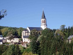 Vista del municipio
| ||||
| ||||
 Johanngeorgenstadt Ubicación en el estado de Sajonia | ||||
 Ubicación en el distrito | ||||
| Coordenadas | 50°26′00″N 12°42′50″E | |||
|---|---|---|---|---|
| Entidad | Municipio | |||
| • País |
| |||
| • Estado | Sajonia | |||
| • Distrito | Erzgebirgskreis | |||
| Superficie | ||||
| • Total | 29,58 km² | |||
| Altitud | ||||
| • Media | 780 m s. n. m. | |||
| Población (31 de marzo de 2022) | ||||
| • Total | 3780 hab. | |||
| • Densidad | 127,79 hab/km² | |||
| Huso horario | UTC+01:00 y UTC+02:00 | |||
| Código postal | 08349[1] | |||
| Prefijo telefónico | 03773 | |||
| Matrícula | ERZ | |||
| Número oficial de comunidad | 14521320 | |||
| Sitio web oficial | ||||


Referencias
- Worldpostalcodes.org, código postal n.º 08349.
- Estadísticas bundestag. Consultado el 7 de junio de 2018
- Estadísticas Sajonia. Consultado el 7 de junio de 2018
- Página web oficial del distrito. Consultado el 8 de junio de 2018
Enlaces externos
- Esta obra contiene una traducción derivada de «Johanngeorgenstadt» de Wikipedia en inglés, publicada por sus editores bajo la Licencia de documentación libre de GNU y la Licencia Creative Commons Atribución-CompartirIgual 3.0 Unported.
 Wikimedia Commons alberga una categoría multimedia sobre Johanngeorgenstadt.
| Control de autoridades |
|---|
 Datos: Q57903
- Multimedia: Johanngeorgenstadt / Q57903
На других языках
[de] Johanngeorgenstadt
Johanngeorgenstadt ist eine Bergstadt im sächsischen Erzgebirgskreis. Sie liegt im Westerzgebirge unmittelbar an der Grenze zu Tschechien.[en] Johanngeorgenstadt
Johanngeorgenstadt (German pronunciation: [ˌjoːhan.ɡeˈɔʁgŋ.ʃtat] (listen)) is a mining town in Saxony’s Ore Mountains, 17 km south of Aue, and 27 km northwest of Karlovy Vary. It lies in the district of Erzgebirgskreis, on the border with the Czech Republic, is a state-recognized health resort (Erholungsort), and calls itself Stadt des Schwibbogens (“Schwibbogen Town”). Its population decline since the 1950s has been extremely severe falling from 45,000 residents in 1953 to only about one tenth of that now.- [es] Johanngeorgenstadt
[ru] Йохангеоргенштадт
Йохангеоргенштадт (нем. Johanngeorgenstadt) — город в Германии, в земле Саксония. Подчинён административному округу Хемниц. Входит в состав района Рудные Горы (район Германии). Население составляет 4681 человек (на 31 декабря 2010 года). Занимает площадь 29,59 км². Официальный код — 14 1 91 180.Текст в блоке "Читать" взят с сайта "Википедия" и доступен по лицензии Creative Commons Attribution-ShareAlike; в отдельных случаях могут действовать дополнительные условия.
Другой контент может иметь иную лицензию. Перед использованием материалов сайта WikiSort.org внимательно изучите правила лицензирования конкретных элементов наполнения сайта.
Другой контент может иметь иную лицензию. Перед использованием материалов сайта WikiSort.org внимательно изучите правила лицензирования конкретных элементов наполнения сайта.
2019-2026
WikiSort.org - проект по пересортировке и дополнению контента Википедии
WikiSort.org - проект по пересортировке и дополнению контента Википедии