world.wikisort.org - Germany
Worfelden is a village in the municipality of Büttelborn, which is located in the triangle formed by the cities of Frankfurt, Mainz and Darmstadt, within the Rhine-Main region.
Worfelden | |
|---|---|
Ortsteil of Büttelborn | |
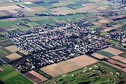
 Aerial photograph of Worfelden (2010) | |
 Coat of arms | |
Location of Worfelden  | |
 Worfelden  Worfelden | |
| Coordinates: 49°55′44″N 08°32′55″E | |
| Country | Germany |
| State | Hesse |
| District | Groß-Gerau |
| Municipality | Büttelborn |
| Area | |
| • Total | 9.6 km2 (3.7 sq mi) |
| Elevation | 96 m (315 ft) |
| Population (2011-12-31)[1] | |
| • Total | 4,536 |
| • Density | 470/km2 (1,200/sq mi) |
| Time zone | UTC+01:00 (CET) |
| • Summer (DST) | UTC+02:00 (CEST) |
| Postal codes | 64572 |
| Dialling codes | 06152 |
Geography
Location
The parish of Worfeld lies entirely within the so-called Hegbach-Apfelbach Bottom (Hegbach-Apfelbach-Grund) in the western Lower Main Plain.[2] In this respect it differs from Lage Büttelborn, whose southwestern corner lies within the Hessian Ried.
In the north Worfelden borders on Mörfelden, in the east on Schneppenhausen (Darmstadt-Dieburg), in the southeast on Braunshardt (Darmstadt-Dieburg), in the southwest on Büttelborn and in the west on Klein-Gerau.
Literature
- Emil Hieke: Die Geschichte Worfeldens. Published by the municipal council (Gemeindeverwaltung), 1959
- Otto Klausing: Die naturräumlichen Einheiten auf Blatt 151 Darmstadt. Bad Godesberg, 1967
- Festschrift 750 Jahre Worfelden, 1975
- There is literature about Worfelden in the Hessian Bibliography
References
- "Gemeinde Büttelborn, Zahlen und Fakten". buettelborn.de. Retrieved 2021-05-23.
- Otto Klausing: Die Naturräume Hessens. Hessische Landesanstalt für Umwelt, Wiesbaden, 1988, ISBN 3-89026-066-7
External links
Wikimedia Commons has media related to Worfelden.
- Geschichte der Ortsteile. In: Webauftritt der Gemeinde Büttelborn.
- "Geschichte Worfeldens". www.worfelden.org. Heimat- & Geschichtsverein Worfelden. Retrieved 2018-04-06.
- Worfelden, Landkreis Groß-Gerau. Historisches Ortslexikon für Hessen. In: Landesgeschichtliches Informationssystem Hessen (LAGIS).
Текст в блоке "Читать" взят с сайта "Википедия" и доступен по лицензии Creative Commons Attribution-ShareAlike; в отдельных случаях могут действовать дополнительные условия.
Другой контент может иметь иную лицензию. Перед использованием материалов сайта WikiSort.org внимательно изучите правила лицензирования конкретных элементов наполнения сайта.
Другой контент может иметь иную лицензию. Перед использованием материалов сайта WikiSort.org внимательно изучите правила лицензирования конкретных элементов наполнения сайта.
2019-2025
WikiSort.org - проект по пересортировке и дополнению контента Википедии
WikiSort.org - проект по пересортировке и дополнению контента Википедии