world.wikisort.org - Germany
Wieda is a village and a former municipality in the district of Göttingen, in Lower Saxony, Germany. Since 1 November 2016, it is part of the municipality Walkenried.
Wieda | |
|---|---|
Ortsteil of Walkenried | |
 Coat of arms | |
Location of Wieda  | |
 Wieda  Wieda | |
| Coordinates: 51°37′57″N 10°35′09″E | |
| Country | Germany |
| State | Lower Saxony |
| District | Göttingen |
| Municipality | Walkenried |
| Area | |
| • Total | 6.53 km2 (2.52 sq mi) |
| Elevation | 375 m (1,230 ft) |
| Population (2015-12-31) | |
| • Total | 1,295 |
| • Density | 200/km2 (510/sq mi) |
| Time zone | UTC+01:00 (CET) |
| • Summer (DST) | UTC+02:00 (CEST) |
| Postal codes | 37447 |
| Dialling codes | 05586 |
| Vehicle registration | GÖ, OHA |
Wieda is on River Wieda, a tributary of Zorge in the southern part of the Harz mountains.
Sights
There are many well-preserved half-timbered houses in the center of Wieda, for example in the High Street close to the wooden Town Hall. The Old Clock Tower is on the top of a hill offering a scenic view of the municipality and its surroundings. Lutherkirche is the protestant town church which was built in 1770.[1]
 Protestant Church
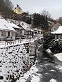 Clock Tower
 Half-timbered houses in the High Street
 River Wieda
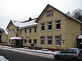 Town Hall


References
Wikimedia Commons has media related to Wieda.
- Ulrich Großmann: Hannover und Südniedersachsen, p. 192. Köln 1999
Authority control | |
|---|---|
| General |
|
| National libraries | |
На других языках
- [en] Wieda
[ru] Вида (коммуна)
Вида (нем. Wieda) — бывшая община (коммуна) в Германии, в земле Нижняя Саксония.Текст в блоке "Читать" взят с сайта "Википедия" и доступен по лицензии Creative Commons Attribution-ShareAlike; в отдельных случаях могут действовать дополнительные условия.
Другой контент может иметь иную лицензию. Перед использованием материалов сайта WikiSort.org внимательно изучите правила лицензирования конкретных элементов наполнения сайта.
Другой контент может иметь иную лицензию. Перед использованием материалов сайта WikiSort.org внимательно изучите правила лицензирования конкретных элементов наполнения сайта.
2019-2026
WikiSort.org - проект по пересортировке и дополнению контента Википедии
WikiSort.org - проект по пересортировке и дополнению контента Википедии