world.wikisort.org - Germany
Rackith is a village and a former municipality in Wittenberg district in Saxony-Anhalt, Germany. Since 1 January 2010, it is part of the town Kemberg.
Rackith | |
|---|---|
Stadtteil of Kemberg | |
Location of Rackith  | |
 Rackith  Rackith | |
| Coordinates: 51°47′59″N 12°40′59″E | |
| Country | Germany |
| State | Saxony-Anhalt |
| District | Wittenberg |
| Town | Kemberg |
| Subdivisions | 2 |
| Area | |
| • Total | 18.99 km2 (7.33 sq mi) |
| Elevation | 67 m (220 ft) |
| Population (2006-12-31) | |
| • Total | 663 |
| • Density | 35/km2 (90/sq mi) |
| Time zone | UTC+01:00 (CET) |
| • Summer (DST) | UTC+02:00 (CEST) |
| Postal codes | 06901 |
| Dialling codes | 034927 |
| Vehicle registration | WB |
| Website | www.vgem-kemberg.de |
Geography
Rackith lies about 12 km southeast of Lutherstadt Wittenberg.
Subdivisions
Rackith has two of these: Lammsdorf and Bietegast.
History
Rackith had its first documentary mention in 1004.

Economy and transportation
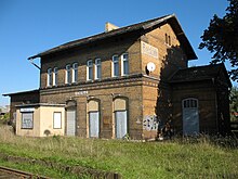
Federal Highway (Bundesstraße) B 182 between Wittenberg and Torgau runs right through the community. Rackith railway station lies on the single-track line between Wittenberg and Bad Schmiedeberg.
References
External links
На других языках
- [en] Rackith
[ru] Раккит
Раккит (нем. Rackith) — коммуна в Германии, в земле Саксония-Анхальт, входит в район Виттенберг, и подчиняется управлению Кемберг.Текст в блоке "Читать" взят с сайта "Википедия" и доступен по лицензии Creative Commons Attribution-ShareAlike; в отдельных случаях могут действовать дополнительные условия.
Другой контент может иметь иную лицензию. Перед использованием материалов сайта WikiSort.org внимательно изучите правила лицензирования конкретных элементов наполнения сайта.
Другой контент может иметь иную лицензию. Перед использованием материалов сайта WikiSort.org внимательно изучите правила лицензирования конкретных элементов наполнения сайта.
2019-2025
WikiSort.org - проект по пересортировке и дополнению контента Википедии
WikiSort.org - проект по пересортировке и дополнению контента Википедии