world.wikisort.org - Germany
Oberrieden is a village in the northern part of Hesse, Germany. First recorded mention was in 1150. Since 1971 it belongs to the town of Bad Sooden-Allendorf.
This article does not cite any sources. (June 2014) |
Oberrieden | |
|---|---|
Stadtteil of Bad Sooden-Allendorf | |
Location of Oberrieden  | |
 Oberrieden  Oberrieden | |
| Coordinates: 51°18′N 9°55′E | |
| Country | Germany |
| State | Hesse |
| Admin. region | Kassel |
| District | Werra-Meißner |
| Town | Bad Sooden-Allendorf |
| Area | |
| • Total | 6.78 km2 (2.62 sq mi) |
| Elevation | 150 m (490 ft) |
| Population | |
| • Total | 650 |
| • Density | 96/km2 (250/sq mi) |
| Time zone | UTC+01:00 (CET) |
| • Summer (DST) | UTC+02:00 (CEST) |
| Postal codes | 37242 |
| Dialling codes | 05542 |
| Vehicle registration | ESW + WIZ |
| Website | Oberrieden |
Location
The village of Oberrieden lies in the Werra valley near the Hoher Meißner, right on the boundary with Thuringia, almost at Germany's geographical centre, 33 km east of Kassel. The Bebra-Göttingen railway touches the village in the east.
Neighbouring villages
Oberrieden borders in the east on the community of Lindewerra (Thuringia's Eichsfeld district), in the south on the village of Ellershausen, in the west on the village Hilgershausen and in the north on the villages of Werleshausen and Wendershausen (town of Witzenhausen).
Gallery
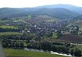 From air
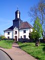 Church
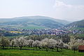 Blossom of cherry tries


External links
- Homepage of Oberrieden (in German)
- Bad Sooden-Allendorf (in German)
| Wikimedia Commons has media related to Oberrieden (Bad Sooden-Allendorf). |
Towns and municipalities in Werra-Meißner-Kreis district | ||
|---|---|---|
 | ||
| Authority control: National libraries |
|---|
Текст в блоке "Читать" взят с сайта "Википедия" и доступен по лицензии Creative Commons Attribution-ShareAlike; в отдельных случаях могут действовать дополнительные условия.
Другой контент может иметь иную лицензию. Перед использованием материалов сайта WikiSort.org внимательно изучите правила лицензирования конкретных элементов наполнения сайта.
Другой контент может иметь иную лицензию. Перед использованием материалов сайта WikiSort.org внимательно изучите правила лицензирования конкретных элементов наполнения сайта.
2019-2026
WikiSort.org - проект по пересортировке и дополнению контента Википедии
WikiSort.org - проект по пересортировке и дополнению контента Википедии