world.wikisort.org - Germany
Glashütten is a small municipality in the Hochtaunuskreis. This community in the Taunus, which is made up of the three formerly independent communities of Glashütten, Schloßborn and Oberems, lies in the Hochtaunus Nature Park, not far from Königstein im Taunus, Germany.
Glashütten | |
|---|---|
Municipality | |
 Glashütten | |
 Coat of arms | |
Location of Glashütten (Taunus) within Hochtaunuskreis district 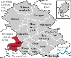 | |
 Glashütten  Glashütten | |
| Coordinates: 50°13′N 8°24′E | |
| Country | Germany |
| State | Hesse |
| Admin. region | Darmstadt |
| District | Hochtaunuskreis |
| Subdivisions | 3 Ortsteile: Glashütten, Schloßborn, Oberems |
| Government | |
| • Mayor (2021–27) | Thomas Ciesielski[1] (CDU) |
| Area | |
| • Total | 27.11 km2 (10.47 sq mi) |
| Highest elevation | 826 m (2,710 ft) |
| Lowest elevation | 350 m (1,150 ft) |
| Population (2020-12-31)[2] | |
| • Total | 5,364 |
| • Density | 200/km2 (510/sq mi) |
| Time zone | UTC+01:00 (CET) |
| • Summer (DST) | UTC+02:00 (CEST) |
| Postal codes | 61479 |
| Dialling codes | 06174 (Glashütten and Schloßborn), 06082 (Oberems) |
| Vehicle registration | HG |
| Website | www.gemeinde-glashuetten.de |
Geography
Neighbouring communities
Glashütten borders in the north on the communities of Waldems (Rheingau-Taunus-Kreis) and Schmitten, in the east on the town of Königstein, in the south on the towns of Kelkheim and Eppstein, and in the west on the town of Idstein (Rheingau-Taunus-Kreis).
Constituent communities
Glashütten consists of the three centres of Glashütten, Oberems and Schloßborn.
Schloßborn
This is arguably the first verifiable settlement in the Idstein Basin, in the area before the Goldener Grund ("Golden Ground"), in the combe in the row of Taunus peaks among Glaskopf (685 m), the Großer Lindenkopf (499 m) and the Hohe Kanzel (595 m).
In terms of road geography it lies in the middle between the Kölnische Straße ("Cologne Road"), now known as the B 8 (Frankfurt - Königstein - Esch - Limburg - Cologne), and the valley road in the basin (Hofheim - Eppstein - Esch).
It is surrounded by low peaks: the Butznickel (462 m), the Rotherberg (446 m), the Maisel (482 m), the Eichkopf (563 m) and the Atzelberg (507 m). Schloßborn's relative wealth of water is due mainly to its location among the headwaters of the Silberbach, the Weiherbach and the Dattenbach.
Statistics
- Elevation: 400 m
- Population: 3000
References
- Direkt gewählte (Ober-) Bürgermeister/-innen der hessischen Städte und Gemeinden, accessed 5 July 2021.
- "Bevölkerung in Hessen am 31.12.2020 nach Gemeinden". Hessisches Statistisches Landesamt (in German). June 2021.
External links
Towns and municipalities in Hochtaunuskreis | ||
|---|---|---|
 | ||
Authority control | |
|---|---|
| General |
|
| National libraries | |
На других языках
- [en] Glashütten (Taunus)
[ru] Гласхюттен (Таунус)
Гласхюттен (нем. Glashütten) — коммуна в Германии, в земле Гессен. Подчиняется административному округу Дармштадт. Входит в состав района Верхний Таунус. Население составляет 5246 человек (на 31 декабря 2010 года).[1] Занимает площадь 27,11 км². Официальный код — 06 4 34 003.Другой контент может иметь иную лицензию. Перед использованием материалов сайта WikiSort.org внимательно изучите правила лицензирования конкретных элементов наполнения сайта.
WikiSort.org - проект по пересортировке и дополнению контента Википедии