world.wikisort.org - Germany
Bündheim (German: [ˈbʏnthaɪm]; Oker dialect: Binten [ˈbɪntən]) is a village that forms a part (Stadtteil) of Bad Harzburg in the district of Goslar in Lower Saxony, Germany. As of 2020, Bündheim had a population of 5,204.[1]
Bündheim
Binten (Low German) | |
|---|---|
Stadtteil of Bad Harzburg | |
 Bündheimer Schloss (Bündheim castle) | |
 Coat of arms | |
Location of Bündheim  | |
 Bündheim  Bündheim | |
| Coordinates: 51°53′24″N 10°32′49″E | |
| Country | Germany |
| State | Lower Saxony |
| District | Bad Harzburg |
| Town | Bad Harzburg |
| Population (2020-12-31)[1] | |
| • Total | 5,204 |
| Time zone | UTC+01:00 (CET) |
| • Summer (DST) | UTC+02:00 (CEST) |
| Postal codes | 38667 |
| Dialling codes | 05322 |
| Vehicle registration | GS |
Geography
Bündheim is positioned between the Harz mountains to the south and the valley of the Radau to the north. The residential area is merged with those of Schlewecke and Bad Harzburg city. The Bleiche, a tributary of the Radau, flows through Bündheim.
History
| Year | Pop. | ±% |
|---|---|---|
| 1798 | 625 | — |
| 1849 | 1,116 | +78.6% |
| 1871 | 1,489 | +33.4% |
| 1925 | 3,048 | +104.7% |
| 1939 | 3,519 | +15.5% |
| 1975 | 7,500 | +113.1% |
| 2011 | 5,213 | −30.5% |
| 2015 | 5,195 | −0.3% |
| 2018 | 5,238 | +0.8% |
| 2020 | 5,204 | −0.6% |
| [2] 1798,[3] 1849 and 1871,[citation needed] 1925–1939,[4] 1975 (estimated),[5] 1997,[6] since 2011. | ||
Etymology
The name Bündheim is a composition of a word cognating to Old High German biunda (separated private lot), meaning that Bündheim was originally part of Schlewecke and later manifested as an own community. Other names were:
- 1251: Buntem
- 1353: Büntem
- 1459: Bünthem
- 19th century: Büntheim
- 20th century: Bündheim
Timeline
It had been seat of the administrative district of Bad Harzburg since 1573 and played a crucial role in the formation of Bad Harzburg. The Bündheim castle as the seat of this district was destroyed in 1626 during Thirty Years' War, after it reconstruction it had to be torn down owing to construction errors.
On January 1, 1963, Bündheim merged with Schlewecke to the new community Bündheim-Schlewecke that was incorporated into Bad Harzburg nine years later, on July 1, 1972.
Infrastructure
Bündheim is penetrated by the Landesstraße L 501, leading from Eckertal at the border to Saxony-Anhalt through Bad Harzburg to Göttingerode and Oker. Until the 1980s, this route was part of the Bundesstraße 6.
Gallery
 Lutheran Andreas church
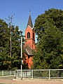 Catholic St. Gregor VII. church
 Industry in Bündheim


References
- "Einwohner der Gemeinden und Ortsteile Stand 31.12.2020". Landkreis Goslar. Retrieved 24 September 2021.
- Wolfgang Heinemann (2003), Die Chronik des Amtes Harzburg (in German), Hanau, p. 378, ISBN 3-00-011170-0
- Harald Meier, Kurt Neumann: Bad Harzburg. Chronik einer Stadt. S. 570.
- Joachim Hellmer (1981), Beiträge zur Kriminalgeographie (in German), Duncker & Humblot, p. 65, ISBN 3-42-844916-9
- Harald Meier, Kurt Neumann: Bad Harzburg. Chronik einer Stadt. S. 717.
- Landkreis Goslar (2018-11-08). "Der Landkreis Goslar im Überblick". Retrieved 2019-01-26.
Authority control | |
|---|---|
| General |
|
| National libraries | |
Другой контент может иметь иную лицензию. Перед использованием материалов сайта WikiSort.org внимательно изучите правила лицензирования конкретных элементов наполнения сайта.
WikiSort.org - проект по пересортировке и дополнению контента Википедии