world.wikisort.org - France
Saint-Pantaléon (French pronunciation: [sɛ̃ pɑ̃taleɔ̃]; Languedocien: Sent Pantaleon) is a former commune in the Lot department in south-western France.[2] On 1 January 2019, it was merged into the new commune Barguelonne-en-Quercy.[3]
Saint-Pantaléon | |
|---|---|
Part of Barguelonne-en-Quercy | |
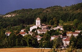
 A general view of Saint-Pantaléon | |
Location of Saint-Pantaléon  | |
 Saint-Pantaléon  Saint-Pantaléon | |
| Coordinates: 44°22′09″N 1°16′00″E | |
| Country | France |
| Region | Occitania |
| Department | Lot |
| Arrondissement | Cahors |
| Canton | Luzech |
| Commune | Barguelonne-en-Quercy |
| Area 1 | 19.37 km2 (7.48 sq mi) |
| Population (2019)[1] | 279 |
| • Density | 14/km2 (37/sq mi) |
| Time zone | UTC+01:00 (CET) |
| • Summer (DST) | UTC+02:00 (CEST) |
| Postal code | 46800 |
| Elevation | 175–305 m (574–1,001 ft) (avg. 193 m or 633 ft) |
| 1 French Land Register data, which excludes lakes, ponds, glaciers > 1 km2 (0.386 sq mi or 247 acres) and river estuaries. | |
Geography
The village lies in the valley of the ruisseau de Fraysse, a tributary of the Barguelonnette, which flows southwestward through the commune.
See also
References
- Téléchargement du fichier d'ensemble des populations légales en 2019, INSEE
- Des villages de Cassini aux communes d'aujourd'hui: Commune data sheet Saint-Pantaléon, EHESS. (in French)
- Arrêté préfectoral 28 September 2018 (in French)
| Wikimedia Commons has media related to Saint-Pantaléon (Lot). |
Текст в блоке "Читать" взят с сайта "Википедия" и доступен по лицензии Creative Commons Attribution-ShareAlike; в отдельных случаях могут действовать дополнительные условия.
Другой контент может иметь иную лицензию. Перед использованием материалов сайта WikiSort.org внимательно изучите правила лицензирования конкретных элементов наполнения сайта.
Другой контент может иметь иную лицензию. Перед использованием материалов сайта WikiSort.org внимательно изучите правила лицензирования конкретных элементов наполнения сайта.
2019-2025
WikiSort.org - проект по пересортировке и дополнению контента Википедии
WikiSort.org - проект по пересортировке и дополнению контента Википедии