world.wikisort.org - France
Oradour-sur-Glane (French pronunciation: [ɔʁaduʁ syʁ ɡlan]; Occitan: Orador de Glana) was a commune in the Haute-Vienne department, New Aquitaine, west central France, as well as the name of the main village within the commune.
Oradour-sur-Glane
| |
|---|---|
Commune | |
 Oradour-sur-Glane Town Hall | |
 Coat of arms | |
Location of Oradour-sur-Glane  | |
 Oradour-sur-Glane  Oradour-sur-Glane | |
| Coordinates: 45°55′58″N 1°01′57″E | |
| Country | France |
| Region | Nouvelle-Aquitaine |
| Department | Haute-Vienne |
| Arrondissement | Rochechouart |
| Canton | Saint-Junien |
| Government | |
| • Mayor (2020–2026) | Philippe Lacroix[1] |
| Area 1 | 38.16 km2 (14.73 sq mi) |
| Population | 2,477 |
| • Density | 65/km2 (170/sq mi) |
| Time zone | UTC+01:00 (CET) |
| • Summer (DST) | UTC+02:00 (CEST) |
| INSEE/Postal code | 87110 /87520 |
| Elevation | 227–312 m (745–1,024 ft) (avg. 285 m or 935 ft) |
| 1 French Land Register data, which excludes lakes, ponds, glaciers > 1 km2 (0.386 sq mi or 247 acres) and river estuaries. | |
History
The original village was destroyed on 10 June 1944, four days after D-Day, when 643 of its inhabitants, including women and children, were massacred by a company of troops belonging to the 2nd SS Panzer Division Das Reich, a Waffen-SS unit of the military forces of Nazi Germany in World War II. A new village was built after the war on a nearby site, but on the orders of president Charles de Gaulle, the original has been maintained as a permanent memorial. The Centre de la mémoire d'Oradour museum is located beside the historic site.
Personalities linked to the commune
- Robert Hébras, born on 29 June 1925 in Oradour-sur-Glane; one of the six survivors of the Oradour-sur-Glane massacre on 10 June 1944.
- Jean-Claude Peyronnet, (1940–), French politician, creator of the Centre of the Memory of Oradour-sur-Glane.
- Sébastien Puygrenier began his football career at US Oradour-sur-Glane where his father and his uncles played.
- Didier Barbelivien, French singer-songwriter, pays tribute to Oradour in his song "Les amants d'Oradour".
Geography
The municipality borders with Javerdat, Cieux, Peyrilhac, Veyrac, Saint-Victurnien and Saint-Brice-sur-Vienne.
Demographics
|
| ||||||||||||||||||||||||||||||||||||||||||||||||||||||||||||||||||||||||||||||||||||||||||||||||||||||||||||||||||
| Source: EHESS[3] and INSEE[4] | |||||||||||||||||||||||||||||||||||||||||||||||||||||||||||||||||||||||||||||||||||||||||||||||||||||||||||||||||||
Gallery
 Map showing modern and former village
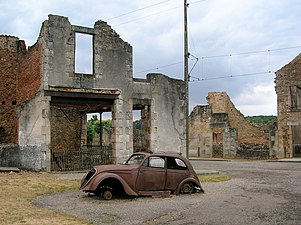 Ruined village


See also
- Quneitra, Syrian city destroyed by Israeli forces and left as an open-air museum
- Lidice, Czech village destroyed by Nazi forces in 1942
References
- "Répertoire national des élus: les maires". data.gouv.fr, Plateforme ouverte des données publiques françaises (in French). 2 December 2020.
- "Populations légales 2019". The National Institute of Statistics and Economic Studies. 29 December 2021.
- Des villages de Cassini aux communes d'aujourd'hui: Commune data sheet Oradour-sur-Glane, EHESS. (in French)
- Population en historique depuis 1968, INSEE
Bibliography
- Farmer, Sarah. Martyred Village: Commemorating the 1944 Massacre at Oradour-sur-Glane. University of California Press, 2000.
- Fouché, Jean-Jacques. Massacre At Oradour: France, 1944; Coming To Grips With Terror, Northern Illinois University Press, 2004.
- Penaud, Guy. La "Das Reich" 2e SS Panzer Division (Parcours de la division en France, 560 pp), Éditions de La Lauze/Périgueux. ISBN 2-912032-76-8
Authority control | |
|---|---|
| General | |
| National libraries | |
| Other |
|
На других языках
[de] Oradour-sur-Glane
Oradour-sur-Glane (okzitanisch Orador de Glana) ist eine französische Gemeinde mit 2477 Einwohnern (Stand 1. Januar 2019) im Département Haute-Vienne in der Region Nouvelle-Aquitaine. Sie liegt 200 Kilometer nordöstlich von Bordeaux und 22 Kilometer nordwestlich von Limoges. Der Ortsname leitet sich vom lateinischen oratorium „Gebetsstätte“ ab.- [en] Oradour-sur-Glane
[ru] Орадур-сюр-Глан
Ораду́р-сюр-Глан (фр. Oradour-sur-Glane) — коммуна (посёлок) во Франции в департаменте Верхняя Вьенна (Новая Аквитания). Население составляет 2188 жителей (2006 год). До войны действовал междугородний трамвай из Лиможа.Другой контент может иметь иную лицензию. Перед использованием материалов сайта WikiSort.org внимательно изучите правила лицензирования конкретных элементов наполнения сайта.
WikiSort.org - проект по пересортировке и дополнению контента Википедии