world.wikisort.org - France
Fakarava is a commune of French Polynesia in the archipelago of the Tuamotu Islands. The commune is in the administrative subdivision of the Îles Tuamotu-Gambier.[1] The commune includes seven islands. The chef-lieu is the village Rotoava.[2]
This article may be expanded with text translated from the corresponding article in French. (July 2017) Click [show] for important translation instructions.
|
Fakarava | |
|---|---|
Commune | |
 View of the inner lagoon of Fakarava from Rotoava | |
 Location (in red) within the Tuamotu Archipelago | |
Location of Fakarava  | |
| Coordinates: 16°03′40″S 145°37′0″W | |
| Country | France |
| Overseas collectivity | French Polynesia |
| Subdivision | Îles Tuamotu-Gambier |
| Area 1 | 110.0 km2 (42.5 sq mi) |
| Population (2017) | 1,637 |
| • Density | 15/km2 (39/sq mi) |
| Time zone | UTC−10:00 |
| INSEE/Postal code | 98716 / |
| Elevation | 0–0 m (0–0 ft) |
| 1 French Land Register data, which excludes lakes, ponds, glaciers > 1 km2 (0.386 sq mi or 247 acres) and river estuaries. | |
Geography
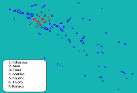
The commune of Fakarava consists of three associated communes: Fakarava (also including the atoll Toau), Kauehi (also including the atolls Aratika, Raraka and Taiaro) and Niau.[2][3]
| Island | Population 2017[3] | Area (km2) | Area of lagoon (km2) |
|---|---|---|---|
| Fakarava | 830 | 24.1 | 1112 |
| Toau | 14 | 12 | 561 |
| Kauehi | 224 | 16 | 320 |
| Aratika | 225 | 8.3 | 145 |
| Raraka | 96 | 14 | 342 |
| Taiaro | 2 | 16.2 | 16.2 |
| Niau | 246 | 21.0 | 53 |
| TOTAL | 1637 | 110.0 | 2533 |
See also
- Communes of French Polynesia
References
- Décret n° 2005-1611 du 20 décembre 2005 pris pour l'application du statut d'autonomie de la Polynésie française, Légifrance
- Décret n°72-407 du 17 mai 1972 portant création de communes dans le territoire de la Polynésie française, Légifrance
- Répartition de la population en Polynésie française en 2017, Institut de la statistique de la Polynésie française
External links
Wikimedia Commons has media related to Fakarava.
| Authority control |
|
|---|
This French Polynesia-related geography article is a stub. You can help Wikipedia by expanding it. |
Текст в блоке "Читать" взят с сайта "Википедия" и доступен по лицензии Creative Commons Attribution-ShareAlike; в отдельных случаях могут действовать дополнительные условия.
Другой контент может иметь иную лицензию. Перед использованием материалов сайта WikiSort.org внимательно изучите правила лицензирования конкретных элементов наполнения сайта.
Другой контент может иметь иную лицензию. Перед использованием материалов сайта WikiSort.org внимательно изучите правила лицензирования конкретных элементов наполнения сайта.
2019-2025
WikiSort.org - проект по пересортировке и дополнению контента Википедии
WikiSort.org - проект по пересортировке и дополнению контента Википедии