world.wikisort.org - France
Brie (French pronunciation: [bʁi] (![]() listen)) is a former commune in the Deux-Sèvres department in the Nouvelle-Aquitaine region in western France. On 1 January 2019, it was merged into the new commune Plaine-et-Vallées.[2]
listen)) is a former commune in the Deux-Sèvres department in the Nouvelle-Aquitaine region in western France. On 1 January 2019, it was merged into the new commune Plaine-et-Vallées.[2]
Brie | |
|---|---|
Part of Plaine-et-Vallées | |
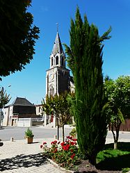
 The church in Brie | |
Location of Brie  | |
 Brie  Brie | |
| Coordinates: 46°55′14″N 0°02′23″W | |
| Country | France |
| Region | Nouvelle-Aquitaine |
| Department | Deux-Sèvres |
| Arrondissement | Bressuire |
| Canton | Le Val de Thouet |
| Commune | Plaine-et-Vallées |
| Area 1 | 11.96 km2 (4.62 sq mi) |
| Population (2019)[1] | 163 |
| • Density | 14/km2 (35/sq mi) |
| Time zone | UTC+01:00 (CET) |
| • Summer (DST) | UTC+02:00 (CEST) |
| Postal code | 79100 |
| Elevation | 50–71 m (164–233 ft) (avg. 88 m or 289 ft) |
| 1 French Land Register data, which excludes lakes, ponds, glaciers > 1 km2 (0.386 sq mi or 247 acres) and river estuaries. | |
Geography
The commune of Brie, located north of the department of Deux-Sèvres, is limited to the east by the department of Vienne. Located 15 kilometers east-southeast of Thouars, it is watered by the Vieille Dive, a secondary arm of the river Dive.
The municipality of Brie is part of the community of communes of Thouarsais and the union of Pays Thouarsais. The town is located at Coordonnées 46° 55′ 14″ north, 0° 02′ 23″ east and at an Altitude of Min. 50 m – Max. 71m.
History
On the map of Cassini showing France between 1756 and 1789, the village is identified as Brye.
By prefectural order of December 4, 1972 effective January 1, 1973, the municipalities of Bilazais, Brie and Noizé merged with Oiron. On 14 February 1983, Brie became independent again (prefectural decree of 11 February 1983).
Policy and administration
List of successive mayors
- Until January 2002 the mayor was Yvon Réau.
- From February 2002 and re-elected in 2008 the mayor was Norbert Bonneau PS.[3]
Places and monuments
- The church whose stained-glass windows were redone in modern form, which brings a very particular luminosity inside the nave
- The old chapel of Sazais
- L'église
- Nef de l'église
- L'ancienne chapelle de Sazais
Demography
| Year | Pop. | ±% p.a. |
|---|---|---|
| 1962 | 334 | — |
| 1968 | 273 | −3.31% |
| 1975 | 253 | −1.08% |
| 1982 | 230 | −1.35% |
| 1990 | 228 | −0.11% |
| 1999 | 208 | −1.01% |
| 2008 | 193 | −0.83% |
| 2017 | 171 | −1.34% |
See also
References
- Téléchargement du fichier d'ensemble des populations légales en 2019, INSEE
- Arrêté préfectoral 7 November 2018 (in French)
- "Élus Deux-Sèvres" (PDF). May 2011. Archived from the original (PDF) on 2011-07-08.
На других языках
[de] Brie (Deux-Sèvres)
Brie ist eine Commune déléguée in der französischen Gemeinde Plaine-et-Vallées mit 163 Einwohnern (Stand: 1. Januar 2019) im Département Deux-Sèvres in der Region Nouvelle-Aquitaine. Sie gehört zum Arrondissement Bressuire und zum Kanton Le Val de Thouet (bis 2015: Kanton Thouars-1). Die Einwohner werden Briolais genannt.- [en] Brie, Deux-Sèvres
Другой контент может иметь иную лицензию. Перед использованием материалов сайта WikiSort.org внимательно изучите правила лицензирования конкретных элементов наполнения сайта.
WikiSort.org - проект по пересортировке и дополнению контента Википедии


