world.wikisort.org - Czech
Lipová (German: Lindenhau) is a municipality and village in Cheb District in the Karlovy Vary Region of the Czech Republic. It has about 700 inhabitants.
Lipová | |
|---|---|
Municipality | |
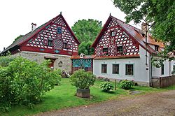
 Traditional timber farm | |
 Lipová Location in the Czech Republic | |
| Coordinates: 50°2′11″N 12°26′56″E | |
| Country | |
| Region | Karlovy Vary |
| District | Cheb |
| First mentioned | 1785 |
| Area | |
| • Total | 45.76 km2 (17.67 sq mi) |
| Elevation | 506 m (1,660 ft) |
| Population (2022-01-01)[1] | |
| • Total | 708 |
| • Density | 15/km2 (40/sq mi) |
| Time zone | UTC+1 (CET) |
| • Summer (DST) | UTC+2 (CEST) |
| Postal code | 350 02 |
| Website | www |
Administrative parts
Villages of Dolní Lažany, Dolní Lipina, Doubrava, Horní Lažany, Mechová, Mýtina, Palič and Stebnice are administrative parts of Lipová.
Geography
Lipová is located about 6 km (4 mi) southeast of Cheb, on the border with Germany.
The northern part of the municipality lies in the Cheb Basin, the southern part extends into the Fichtel Mountains and the southeastern part into the Upper Palatine Forest. The highest point is located on the southeastern municipal border, on the slopes of the Dyleň mountain, at about 825 m (2,707 ft). Near the village of Mýtina there is the Železná hůrka National Nature Monument with an extinct Quaternary volcano.
References
- "Population of Municipalities – 1 January 2022". Czech Statistical Office. 2022-04-29.
На других языках
[de] Lipová u Chebu
Lipová (deutsch Lindenhau) ist eine Gemeinde im Okres Cheb im Karlovarský kraj in Tschechien.- [en] Lipová (Cheb District)
Другой контент может иметь иную лицензию. Перед использованием материалов сайта WikiSort.org внимательно изучите правила лицензирования конкретных элементов наполнения сайта.
WikiSort.org - проект по пересортировке и дополнению контента Википедии

