world.wikisort.org - Czech
Anenská Studánka (German: Königsfeld) is a municipality and village in Ústí nad Orlicí District in the Pardubice Region of the Czech Republic. It has about 200 inhabitants.
Anenská Studánka | |
|---|---|
Municipality | |
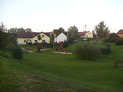
 Park in the centre of Anenská Studánka | |
 Flag  Coat of arms | |
 Anenská Studánka Location in the Czech Republic | |
| Coordinates: 49°50′59″N 16°32′25″E | |
| Country | |
| Region | Pardubice |
| District | Ústí nad Orlicí |
| First mentioned | 1292 |
| Area | |
| • Total | 7.91 km2 (3.05 sq mi) |
| Elevation | 505 m (1,657 ft) |
| Population (2022-01-01)[1] | |
| • Total | 170 |
| • Density | 21/km2 (56/sq mi) |
| Time zone | UTC+1 (CET) |
| • Summer (DST) | UTC+2 (CEST) |
| Postal code | 563 01 |
| Website | www |
Administrative parts
The hamlet of Helvíkov is an administrative part of Anenská Studánka.
Geography
Anenská Studánka is located about 17 kilometres (11 mi) southeast of Ústí nad Orlicí and 57 km (35 mi) southeast of Pardubice. It lies in the Podorlická Uplands. The highest point is 641 metres (2,103 ft) above sea level.
History
The first written mention of Anenská Studánka is from 1292, when it was owned by the Zbraslav Monastery.[2]
Sights
The landmark of Anenská Studánka is the Church of Saint Lawrence. It was built in 1907, on the site of an old church from 1607.[2]
References
- "Population of Municipalities – 1 January 2022". Czech Statistical Office. 2022-04-29.
- "Historie obce" (in Czech). Obec Anenská Studánka. Retrieved 2022-06-24.
External links
Wikimedia Commons has media related to Anenská Studánka.
Текст в блоке "Читать" взят с сайта "Википедия" и доступен по лицензии Creative Commons Attribution-ShareAlike; в отдельных случаях могут действовать дополнительные условия.
Другой контент может иметь иную лицензию. Перед использованием материалов сайта WikiSort.org внимательно изучите правила лицензирования конкретных элементов наполнения сайта.
Другой контент может иметь иную лицензию. Перед использованием материалов сайта WikiSort.org внимательно изучите правила лицензирования конкретных элементов наполнения сайта.
2019-2025
WikiSort.org - проект по пересортировке и дополнению контента Википедии
WikiSort.org - проект по пересортировке и дополнению контента Википедии