world.wikisort.org - Cuba
Vega Alta is a small town in Camajuaní, Villa Clara, Cuba and a Popular Council. It is in the vicinity of the Sagua la Chica River, with neighboring towns such as Canoa, Chicharón, Rincón, La Levisa, La Luz, La Catalina, La Doncella, and El Cubano.[4]
Vega Alta | |
|---|---|
Village [1] | |
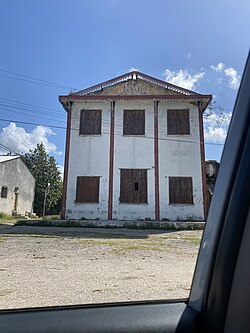
 The back of the Railstation in Vega Alta | |
 Map of Vega Alta (Red) in Camajuaní (Orange) in Villa Clara (Yellow) | |
 Vega Alta Map of where Vega Alta is in Cuba | |
| Coordinates: 22°32′59″N 79°49′08″W | |
| Country | Cuba |
| Province | Villa Clara |
| Municipality | Camajuaní |
| Popular Council | Vega Alta |
| Foundation | 1883 |
| Area | |
| • Total | 0.3700 km2 (0.1429 sq mi) |
| Population | |
| • Total | 1,061 |
| • Density | 2,900/km2 (7,400/sq mi) |
| Demonym | Vegaltense |
| Postal Code [3] | 52500 |
”Vega Alta” translates to “high valley” in English.
Popular Council

The Vega Altas Popular Council is a local body of Vega Alta and towns nearby.
Towns in Vega Altas Popular Council include:
- Rincón
- Chicharón
- La Levisa
- El Cubano (or La Flora)
- CPA Benito Ramírez
- Guerrero
- San Juan
- La Doncella
- Piedra
- Guajén
- La Lorenza
El Cubano
El Cubano also known as La Flora is a small town in Vega Alta Popular Council.
History
Three months after the Ten Years' War started fighting broke out in Remedios. On February 14, 1869, a Venezuelan named Salomé Hernández, who was working for Dos Hermanos de los Fusté Suger Mill, got armed and took some slaves from the Ingenio. Salomé and her troops were aimed at burning sugar mills in El Cubano and other towns nearby.[5]
Education

- Wilfredo Cabrera Portal in El Rincón
- Benito Ramírez Rodríguez in CPA Benito Ramírez
- Juan Francisco Aro in the main town of Vega Alta
- Serafín Sánchez Valdivia in Guerrero
- Raúl Torres Acosta in Piedra
- Rolando Vera Martínez in Guajén
- Boris Luis Santa Coloma in La Lorenza
- Wilfredo Cabrera Portal in the main town of Vega Alta
- Leoncio Vidal in El Purial
Geography
Nearby places that are north, northeast, east, southeast, south, southwest, west, and northwest of the town are:
Farmland
Canoa ![]()
![]()
![]() Rincón
Rincón
Farmland ![]()
![]() Farmland
Farmland
Farmland ![]()
![]()
![]() La Luz
La Luz
Carmita
History
Vega Alta was founded in 1883 when the families of Rafael Pérez Borroto, Don Vicente Revuelta and Manuela Rodríguez settled there.[citation needed] Until 1976 Vega Alta was a part of San Antonio de las Vueltas Municipality.[6]
See also
- Aguada de Moya, Cuba
- La Quinta, Cuba
- José María Pérez, Cuba
- Chorrerón, Cuba
References
- "Node: Vega Alta (1546398655)".
- "Camajuaní (Municipality, Villa Clara Province, Cuba) - Population Statistics, Charts, Map and Location".
- "Vega Alta Villa Clara Postal / ZIP Codes". getpostalcodes.com.
- "List of Cities near Vega Alta in Villa Clara, Cuba". www.gomapper.com. Retrieved 2022-06-27.
- "Portal del Ciudadano en Camajuaní - Un poco de historia".
- "San Antonio de las Vueltas". www.guije.com. Retrieved 2022-08-27.
Другой контент может иметь иную лицензию. Перед использованием материалов сайта WikiSort.org внимательно изучите правила лицензирования конкретных элементов наполнения сайта.
WikiSort.org - проект по пересортировке и дополнению контента Википедии