world.wikisort.org - Chine
Le xian de Yarkand (莎车县, ; ouïghour : يەكەن ناھىيىسى / Yeken Nahiyisi) est un district administratif de la région autonome du Xinjiang en Chine. Il est placé sous la juridiction de la préfecture de Kachgar. Son chef-lieu est la ville-oasis de Yarkand, située entre Kachgar (Kashi) et Khotan (Hetian) sur la branche de la Route de la soie qui contournait le désert du Taklamakan par le sud.
Cette page contient des caractères spéciaux ou non latins. Si certains caractères de cet article s’affichent mal (carrés vides, points d’interrogation, etc.), consultez la page d’aide Unicode.
Pour les articles homonymes, voir Yarkand (homonymie).
Cet article est une ébauche concernant une localité chinoise.
Vous pouvez partager vos connaissances en l’améliorant (comment ?) selon les recommandations des projets correspondants.
| Shāchē Xiàn (Yeken Nahiyisi) 莎车县 يەكەن ناھىيىسى | |||
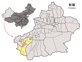 Localisation du xian de Yarkand (en rose) dans la préfecture de Kachgar (en jaune) | |||
| Administration | |||
|---|---|---|---|
| Pays | |||
| Province ou région autonome | Xinjiang | ||
| Préfecture | Kachgar | ||
| Statut administratif | Xian | ||
| Code postal | 844700[1] | ||
| Indicatif | +86 (0)+86 (0)998 | ||
| Immatriculation | 新Q | ||
| Démographie | |||
| 613 671 hab. (1999) | |||
| Densité | 69 hab./km2 | ||
| Géographie | |||
| Coordonnées | 37° 52′ 00″ nord, 77° 24′ 00″ est | ||
| Altitude | 1 189 m |
||
| Superficie | 895 669 ha = 8 956,69 km2 | ||
| Localisation | |||
|
| |||
| Géolocalisation sur la carte : Chine
Géolocalisation sur la carte : Chine
| |||
| Liens | |||
| Site web | gat.xinjiang.gov.cn/ | ||
| modifier |
|||


Elle était la capitale du Khanat de Yarkand (1514 — 1705).
Démographie
La population du district était de 613 671 habitants en 1999[2].
Patrimoine
- Le cimetière royal du Khanat de Yarkand
- La mosquée Altyn
- Le mausolée d'Amannisa Khan
Galerie
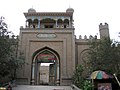 Porte de la cité antique
 Rue à Yarkand
 Scène de rue à Yarkand
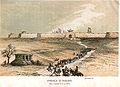 La ville de Yarkand en 1868


Voir aussi
- Yarkand
- Yarkand (fleuve)
Notes et références
- (en) Codes postaux et téléphoniques du Xinjiang, (en) China Zip Code/ Telephone Code, ChinaTravel.
- (en) National Population Statistics Materials by County and City - 1999 Period, in China County & City Population 1999, Harvard China Historical GIS
Articles connexes
- Makan Map
 Portail de la Chine
На других языках
[de] Yarkant
Yarkant, auch Jarkand oder Jarkend genannt, ist ein Kreis des Regierungsbezirks Kaschgar im Uigurischen Autonomen Gebiet Xinjiang der Volksrepublik China. Er hat eine Fläche von 9.037 km² und 762.385 Einwohner (Stand: Zensus 2010).[1][en] Yarkant County
Yarkant County,[4][5][6] also Shache County,[7] also transliterated from Uyghur as Yakan County, is a county in the Xinjiang Uyghur Autonomous Region, China, located on the southern rim of the Taklamakan Desert in the Tarim Basin. It is one of 11 counties administered under Kashgar Prefecture. The county, usually referred to as Yarkand[8] in English, was the seat of an ancient Buddhist kingdom on the southern branch of the Silk Road and the Yarkand Khanate. The county sits at an altitude of 1,189 metres (3,901 ft) and as of 2003[update] had a population of 373,492.- [fr] Xian de Yarkand
[ru] Яркенд
Уезд Ярке́нд (уйг. يەكەن ناھىيىسى, Йәркәнд наһийиси) или уезд Шачэ (кит. упр. 莎车县, пиньинь Shāchē xiàn) — оазис и уезд в Синьцзян-Уйгурском автономном районе Китая, к юго-востоку от Кашгара и к северо-западу от Хотана, на высоте 1189 м над уровнем моря. Берёт название от реки Яркенд.Другой контент может иметь иную лицензию. Перед использованием материалов сайта WikiSort.org внимательно изучите правила лицензирования конкретных элементов наполнения сайта.
WikiSort.org - проект по пересортировке и дополнению контента Википедии