world.wikisort.org - Chine
Le xian de Lop (洛浦县 ; pinyin : Luòpǔ Xiàn ; ouïghour : لوپ ناھىيىسى / Lop Nahiyisi) est un district administratif de la région autonome du Xinjiang en Chine. Il est placé sous la juridiction de la préfecture de Hotan.
Cette page contient des caractères spéciaux ou non latins. Si certains caractères de cet article s’affichent mal (carrés vides, points d’interrogation, etc.), consultez la page d’aide Unicode.
Pour les articles homonymes, voir Lop.
Cet article est une ébauche concernant la Chine.
Vous pouvez partager vos connaissances en l’améliorant (comment ?) selon les recommandations des projets correspondants.
| Luòpǔ Xiàn (Lop Nahiyisi) 洛浦县 (لوپ ناھىيىسى) | |||
 Localisation du xian de Lop (en rose) dans la préfecture de Hotan (en jaune) | |||
| Administration | |||
|---|---|---|---|
| Pays | |||
| Province ou région autonome | Xinjiang | ||
| Préfecture | Hotan | ||
| Statut administratif | Xian | ||
| Code postal | 848200[1] | ||
| Indicatif | +86 (0)903 | ||
| Immatriculation | 新R | ||
| Démographie | |||
| 228 017 hab. (1999) | |||
| Densité | 16 hab./km2 | ||
| Géographie | |||
| Coordonnées | 37° 01′ 00″ nord, 80° 16′ 00″ est | ||
| Superficie | 1 411 361 ha = 14 113,61 km2 | ||
| Localisation | |||
|
| |||
| Géolocalisation sur la carte : Chine
Géolocalisation sur la carte : Chine
| |||
| Liens | |||
| Site web | www.lp.gov.cn | ||
| modifier |
|||


Démographie
La population du district était de 228 017 habitants en 1999[2].
Galerie
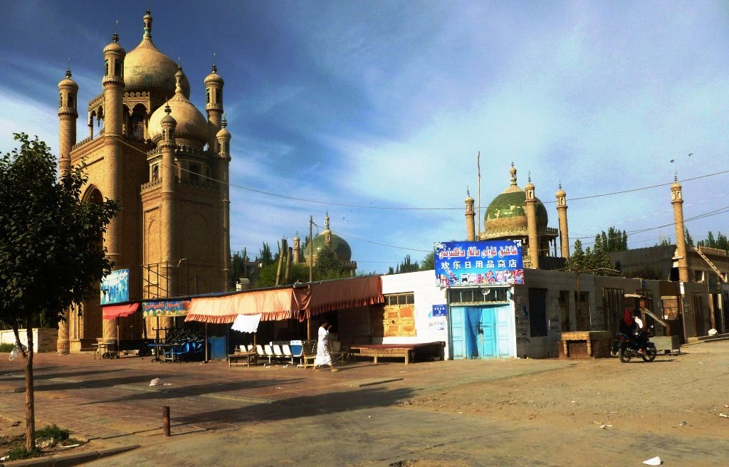
 Ancienne et nouvelle mosquées de Lop, le 18 juin 2011.
 Mur d'enceinte du stupa de Rawak, coin sud, avec protection en pierre moderne, le 17 novembre 2008.
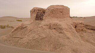 Stupa de Rawak dans le désert du Taklamakan, le 5 octobre 2009.


Notes et références
- (en) Codes postaux et téléphoniques du Xinjiang, (en) China Zip Code/ Telephone Code, ChinaTravel.
- (en) National Population Statistics Materials by County and City - 1999 Period, in China County & City Population 1999, Harvard China Historical GIS
Voir aussi
Articles connexes
- Makan Map
Lien externe
- (zh) Site gouvernemental
 Portail de la Chine
На других языках
[de] Lop
Der Kreis Lop (chinesisch .mw-parser-output .Hans{font-size:110%}洛浦县, Pinyin Luòpǔ Xiàn, uigurisch .mw-parser-output .Arab a,.mw-parser-output a bdi.Arab{text-decoration:none!important}.mw-parser-output .Arab{font-size:120%}لوپ ناھىيىسى .mw-parser-output .Latn{font-family:"Akzidenz Grotesk","Arial","Avant Garde Gothic","Calibri","Futura","Geneva","Gill Sans","Helvetica","Lucida Grande","Lucida Sans Unicode","Lucida Grande","Stone Sans","Tahoma","Trebuchet","Univers","Verdana"}Lop Naⱨiyisi) ist ein Kreis des Regierungsbezirks Hotan im Süden des Uigurischen Autonomen Gebiets Xinjiang im Nordwesten der Volksrepublik China. Er hat eine Fläche von 14.314 km² und zählt 232.916 Einwohner (Stand: Zensus 2010).[1][en] Lop County
Lop[5][6][7][8][9] County (pronunciation (help·info),[10] Uyghur: لوپ ناھىيىسى), also Luopu[11][12] (from Mandarin Chinese), is a county in Hotan Prefecture, in the southwest of the Xinjiang Uyghur Autonomous Region, China. Almost all the residents of the county are Uyghur and live around oases situated between the desolate Taklamakan Desert and Kunlun Mountains. The county is bordered to the north by Aksu and Awat County in Aksu Prefecture,[1] to the east by Qira/Chira County, to the northwest by Karakax County, to the west by Hotan (Khotan) and to the south and west by Hotan County.- [fr] Xian de Lop
[ru] Лоп (уезд)
Уезд Лоп (уйг. لوپ ناھىيىسى) или Уезд Лопу́ (кит. упр. 洛浦县, пиньинь Luòpǔ xiàn) — уезд в округе Хотан Синьцзян-Уйгурского автономного района КНР.Текст в блоке "Читать" взят с сайта "Википедия" и доступен по лицензии Creative Commons Attribution-ShareAlike; в отдельных случаях могут действовать дополнительные условия.
Другой контент может иметь иную лицензию. Перед использованием материалов сайта WikiSort.org внимательно изучите правила лицензирования конкретных элементов наполнения сайта.
Другой контент может иметь иную лицензию. Перед использованием материалов сайта WikiSort.org внимательно изучите правила лицензирования конкретных элементов наполнения сайта.
2019-2026
WikiSort.org - проект по пересортировке и дополнению контента Википедии
WikiSort.org - проект по пересортировке и дополнению контента Википедии