world.wikisort.org - Chine
La bannière centrale droite de Chahar (chinois simplifié : 察哈尔右翼中旗 ; pinyin : ) est une subdivision administrative de la région autonome de Mongolie-Intérieure en Chine. Elle est placée sous la juridiction de la ville-préfecture d'Ulaan Chab.
Pour les articles homonymes, voir Chahar.
Cet article est une ébauche concernant la Chine.
Vous pouvez partager vos connaissances en l’améliorant (comment ?) selon les recommandations des projets correspondants.
| cháhā'ěr yòuyì zhōngqí 察哈尔右翼中旗 | |||
 Parc éolien de Huitengxile | |||
| Administration | |||
|---|---|---|---|
| Pays | |||
| Province ou région autonome | Mongolie-Intérieure | ||
| Préfecture | Ulaan Chab | ||
| Statut administratif | Bannière | ||
| Code postal | 013500[1] | ||
| Indicatif | +86 (0) | ||
| Démographie | |||
| 149 483 hab. () | |||
| Densité | 36 hab./km2 | ||
| Géographie | |||
| Coordonnées | 41° 16′ 37″ nord, 112° 38′ 06″ est | ||
| Altitude | 1 734 m |
||
| Superficie | 418 549 ha = 4 185,49 km2 | ||
| Localisation | |||
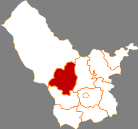
| |||
| Géolocalisation sur la carte : Chine
Géolocalisation sur la carte : Chine
| |||
| Liens | |||
| Site web | www.cyzq.gov.cn | ||
| modifier |
|||


Démographie
La population de la bannière était de 219 605 habitants en 1999[2].
Notes et références
- (en) Codes postaux et téléphoniques de la Mongolie-Intérieure, (en) Zip Code, ChinaTravel.
- (en) National Population Statistics Materials by County and City - 1999 Period, in China County & City Population 1999, Harvard China Historical GIS
Voir aussi
Lien externe
- (zh) Site gouvernemental
 Portail de la Mongolie
  Portail de la Chine
На других языках
[de] Mittleres Qahar-Banner des Rechten Flügels
Das Mittlere Qahar-Banner des Rechten Flügels (chinesisch .mw-parser-output .Hans{font-size:110%}察哈尔右翼中旗, Pinyin Cháhā'ěr Yòuyì Zhōng Qí; mongolisch ᠴᠠᠬᠠᠷ ᠪᠠᠷᠠᠭᠤᠨ ᠭᠠᠷᠤᠨ ᠳᠤᠮᠳᠠᠳᠤ ᠬᠣᠰᠢᠭᠤ Čaqar Baraɣun Ɣarun Dumdadu qosiɣu) ist ein Banner der bezirksfreien Stadt Ulanqab im Zentrum des Autonomen Gebiets Innere Mongolei im Norden der Volksrepublik China. Es hat eine Fläche von 4.200 km² und zählt 210.000 Einwohner (2004). Sein Hauptort ist die Großgemeinde Hobor (科布尔镇).[en] Qahar Right Middle Banner
Chahar Right Middle Banner (Mongolian: ᠴᠠᠬᠠᠷ ᠪᠠᠷᠠᠭᠤᠨ ᠭᠠᠷᠤᠨ ᠳᠤᠮᠳᠠᠳᠤ ᠬᠣᠰᠢᠭᠤ; Цахар баруун гарын дундад хошуу; Čaqar Baraɣun Ɣarun Dumdadu qosiɣu; simplified Chinese: 察哈尔右翼中旗; traditional Chinese: 察哈爾右翼中旗; pinyin: Cháhā'ěr Yòuyì Zhōngqí) is a banner (county equivalent) of Inner Mongolia, People's Republic of China, bordered by Chahar Right Back Banner to the east, Zhuozi County to the south, and Siziwang Banner to the northwest. It is under the administration of Ulaan Chab City.- [fr] Bannière centrale droite de Chahar
[ru] Чахар-Юичжунци
Хошун Чахар-Юичжунци (кит. упр. 察哈尔右翼中旗, пиньинь Cháhā'ěr Yòuyì Zhōngqí, монг. Цахар дунд баруун хошуу), сокращённо хошун Чаюцянь (кит. упр. 察右中旗, пиньинь CháYòuZhōng qí) — хошун городского округа Уланчаб автономного района Внутренняя Монголия (КНР). Название хошуна означает «Среднее знамя чахарского правого крыла».Текст в блоке "Читать" взят с сайта "Википедия" и доступен по лицензии Creative Commons Attribution-ShareAlike; в отдельных случаях могут действовать дополнительные условия.
Другой контент может иметь иную лицензию. Перед использованием материалов сайта WikiSort.org внимательно изучите правила лицензирования конкретных элементов наполнения сайта.
Другой контент может иметь иную лицензию. Перед использованием материалов сайта WikiSort.org внимательно изучите правила лицензирования конкретных элементов наполнения сайта.
2019-2025
WikiSort.org - проект по пересортировке и дополнению контента Википедии
WikiSort.org - проект по пересортировке и дополнению контента Википедии