world.wikisort.org - China
Yangjie Township (simplified Chinese: 羊街乡; traditional Chinese: 羊街鄉; pinyin: Yangjie Xiāng) is a township in Yuanjiang Hani, Yi and Dai Autonomous County, Yunnan, China.[1] As of the 2017 census it had a population of 17,488 and an area of 161-square-kilometre (62 sq mi).
Yangjie Township
羊街乡 | |
|---|---|
Township | |
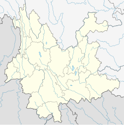
 Yangjie Township Location in Yunnan. | |
| Coordinates: 23°26′27″N 102°03′20″E | |
| Country | People's Republic of China |
| Province | Yunnan |
| Prefecture-level city | Yuxi |
| Autonomous county | Yuanjiang Hani, Yi and Dai Autonomous County |
| Area | |
| • Total | 161 km2 (62 sq mi) |
| Population (2017) | |
| • Total | 17,488 |
| • Density | 110/km2 (280/sq mi) |
| Time zone | UTC+08:00 (China Standard) |
| Postal code | 653305 |
| Area code | 0877 |
Administrative division
As of 2016, the township is divided into one community and five villages:
- Yangjie Community (羊街社区)
- Guodi (锅底村)
- Bamu (坝木村)
- Dangduo (党舵村)
- Zhixia (垤霞村)
- Langzhi (朗支村)
Geography
The township sits at the southern Yuanjiang Hani, Yi and Dai Autonomous County. It borders Lijiang Subdistrict in the northeast, Nanuo Township in the south, and Yinyuan Town in the west.
The highest point is Mount Aboli (阿波里山), elevation 2,580 metres (8,460 ft).
There are five major rivers and streams in the township, namely the Qingshui Rivers (清水河), Gezhi River (戈垤河), Nanman River (南满河), Kunjiu River (昆酒河), and Kunhao River (昆蒿河).
Economy
The region's economy is based on agriculture.[1] Tea, sugarcane, tobacco are the economic plants of this region.[1] The region abounds with rubies.[1]
Transportation
The township is connected to two highways: the National Highway G553 and the Yuanjiang–Manhao Expressway (元蔓高速公路).
References
- Yan Zhongwu 2008, p. 28.
Bibliography
- Yan Zhongwu, ed. (2008). "Administrative divisions" 行政区划. 《元江哈尼族彝族傣族自治县概况》 [General Situation of Yuanjiang Hani, Yi and Dai Autonomous County] (in Chinese). Beijing: Nationalities Publishing House. ISBN 978-7-105-08564-4.
Другой контент может иметь иную лицензию. Перед использованием материалов сайта WikiSort.org внимательно изучите правила лицензирования конкретных элементов наполнения сайта.
WikiSort.org - проект по пересортировке и дополнению контента Википедии