world.wikisort.org - China
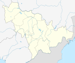
Xinzhan (simplified Chinese: 新站镇; traditional Chinese: 新站鎮; pinyin: Xīnzhàn Zhèn) is a town in the county-level city of Jiaohe, Jilin, China. It is located in 17 kilometers north of Jiaohe's city center.[1] To the east and north are Shulan, Qianjin, the south is Lafa, the west is Tiangang.[1] The town has an area of 571.7 square kilometers,[2] and is divided into 1 residential community and 31 administrative villages.[3] The government sent organs is located at the town-city,[2] and the area of town-city is 3.7 km2.[4]
Xinzhan
新站镇 | |
|---|---|
Town | |
 | |
 Xinzhan | |
| Coordinates: 43°52′N 127°20′E | |
| Country | China |
| Province | Jilin |
| County-level city | Jiaohe |
| Area | |
| • Total | 571.7 km2 (220.7 sq mi) |
| Population (2000) | |
| • Total | 39,629 |
| Xinzhan, Jiaohe | |||||||||||||||
|---|---|---|---|---|---|---|---|---|---|---|---|---|---|---|---|
| Traditional Chinese | 新站鎮 | ||||||||||||||
| Simplified Chinese | 新站镇 | ||||||||||||||
| |||||||||||||||
History
During the Qing Dynasty, a relay station named Lafa Relay Station (simplified Chinese: 拉法驿站; traditional Chinese: 拉法驛站) moved to the area, and was colloquially known as "Xinzhan" (lit. new station).[2]
The area was organized as a bao (Chinese: 保) in 1933, and was re-organized as a street (Chinese: 街; pinyin: Jiē) in 1938, and as a town in 1954.[2] Xinzhan was re-organized as a people's commune in 1958, and was reverted to a town in 1985.[2] Longfeng Township (simplified Chinese: 龙凤乡; traditional Chinese: 龍鳳鄉) was merged into Xinzhan at 2001.[2]
At 2018, two of the town's residential communities, Xinyi (Chinese: 新驿) and Xinyue (Chinese: 新跃) were merged as one, called Xinyu (Chinese: 新毓).[3]
The Lafa-Xinzhan battle was fight at here, in the June 8 and June 10, the KMT army was fighting with CCP, the battle was ended here, and KMT was failed.[5]
Geography
The town is located in the Xinzhan basin, with Mount Dahuangdingzi (大荒頂子山) to the east, Mount Laoye (老爺嶺) to the northwest, and Mount Lafa (拉法山) to the south.[1] The town's tallest mountain is Mount Xitu (西土山) with the altitude of 1189.3 m.[1] The town is largely forested, and has three forest farms: Pingchuan (平川), Longfeng (龍鳳), Laoyeling (老爺嶺).[6] The town is located in the Changbai Mountains.[4]
Longfeng River flows in the town's east, Laoyeling River flows through the west, and Minzhu River (Chinese: 民主河) flows through the north.[1] In the town's south, they converge, forming the Lafa River,[1] which eventually flows into Songhua Lake.
Demographics
Xinzhan has 44,569 people (2012), among them has 20,311 people is citizens.[1]
As of the 2000 Chinese Census, Xinzhan had a population of 39,629.[7]
Administrative divisions
Xinzhan has 1 residential community and 31 administrative villages.[3]
- Communities: Xinyu (新毓)
- Villages: Shimenzi (石門子), Baoshan (寶山), Shuangwang (雙旺), Changyou (長友), Shuangdingzi (雙頂子), Jiliang (基良), Fu'an (富安), Longfeng (龍鳳), Lengfengkou (冷風口), Bao'an (保安), Kaoshan (靠山), Zhenzhu (珍珠), Pingyuan (平原), Fuxing (復興), Yangyu (養魚), Donggou (東溝), Chaoyang (朝陽), Liujiazi (六家子), Wujiazi (五家子), Jixiang (吉祥), Laoyeling (老爺嶺), Bei'an (北安), Xiaogujia (小姑家), Dali (大利), Wenhua (文化), Henan (河南), Aihe (艾河), Renhe (仁和), Xinzhan (新站), Shucai (蔬菜), Xinxian (新鮮)
Transport
The Lafa–Harbin railway and Jilin Provincial Highway 204 both pass through the town.[2] The Xinzhan Railway Station serves as a stop on the Lafa-Harbin railway.[6]
References
- "新站鎮概況". Xinzhan town. 2012-10-26. Retrieved 2015-03-09.
- 新站镇. xzqh.org (in Chinese). 2011-03-22. Archived from the original on 2020-09-01. Retrieved 2020-09-01.
- 2018年统计用区划代码和城乡划分代码 (in Chinese). National Bureau of Statistics of China. 2018.
- "吉林吉林市蛟河市新站鎮". 博雅地名網. Retrieved 2015-03-09.
- "拉法「六七」戰鬥烈士紀念碑". 松花江網. 2014-09-24. Retrieved 2015-03-09.
- "新站鎮投資優勢". Xinzhan town. 2012-10-26. Retrieved 2015-03-09.
- 蛟河市历史沿革. xzqh.org (in Chinese). 2011-05-19. Archived from the original on 2020-09-01. Retrieved 2020-09-01.
Другой контент может иметь иную лицензию. Перед использованием материалов сайта WikiSort.org внимательно изучите правила лицензирования конкретных элементов наполнения сайта.
WikiSort.org - проект по пересортировке и дополнению контента Википедии